Iguazú Falls or Iguaçu Falls (depending on which country you are in) are waterfalls on the Iguazu River at the border of Argentina and Brazil. The falls are taller than Niagara Falls (in Canada) and wider than Victoria Falls (on the Zimbabwe/Zambia border). It is truly one of the most impressive waterfalls in the world and lives up to all the hype.


Some context
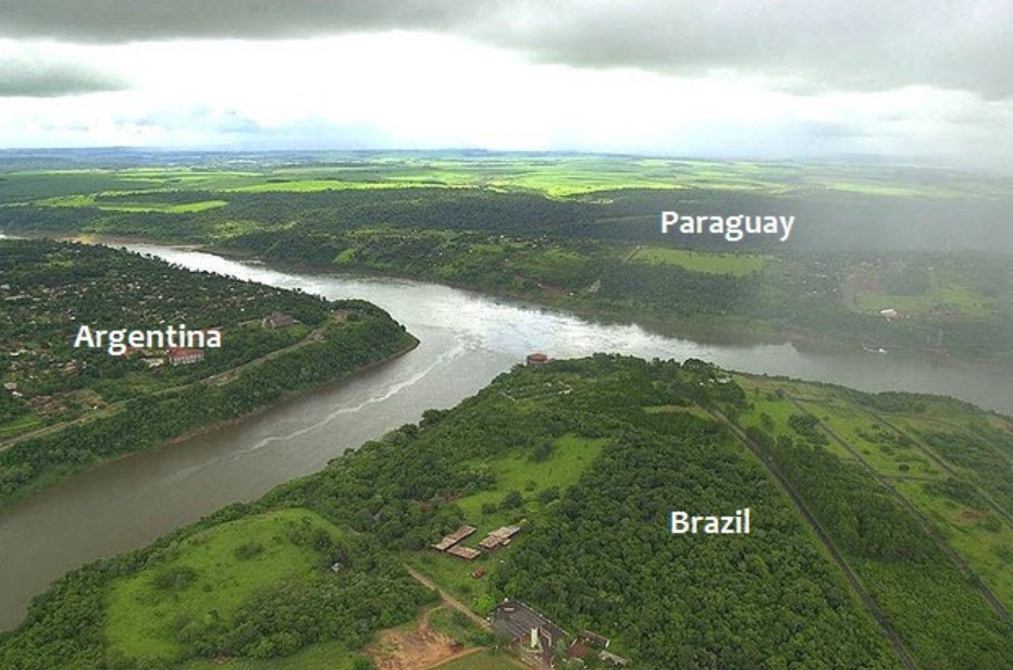
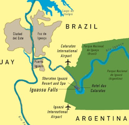
The falls are on the tri-border of Argentina, Brazil and Paraguay, however there is no views of the falls available from the Paraguay side.
In fact Paraguay is a bit of a tax haven and is cheaper (than Brazil at least) and has no sales tax. So if shopping is your thing then planning a quick trip across the Friendship Bridge (over the Paraná river) to Ciudad del Este for some tax free items might be on your list.
It was not on ours, although we did toy with the idea.
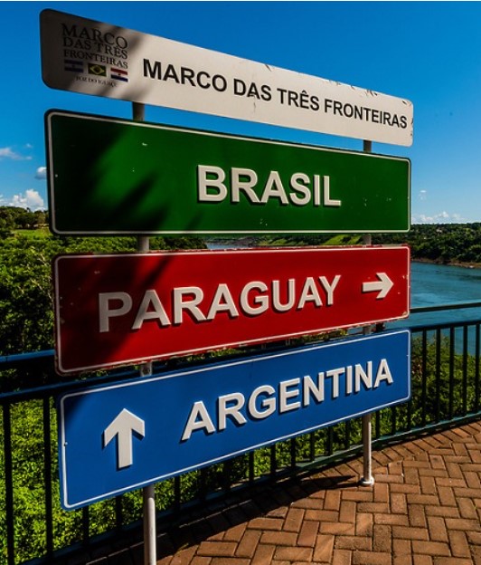
Foz do Iguaçu is the Brazilian town of the tri-national region, bordering the Argentine city of Puerto Iguazú and the Paraguayan city of Ciudad del Este. Our trip saw us having 2 days on the Brazil side and 3 days in Argentina.
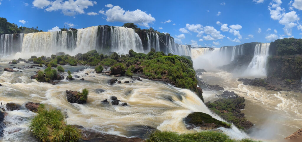
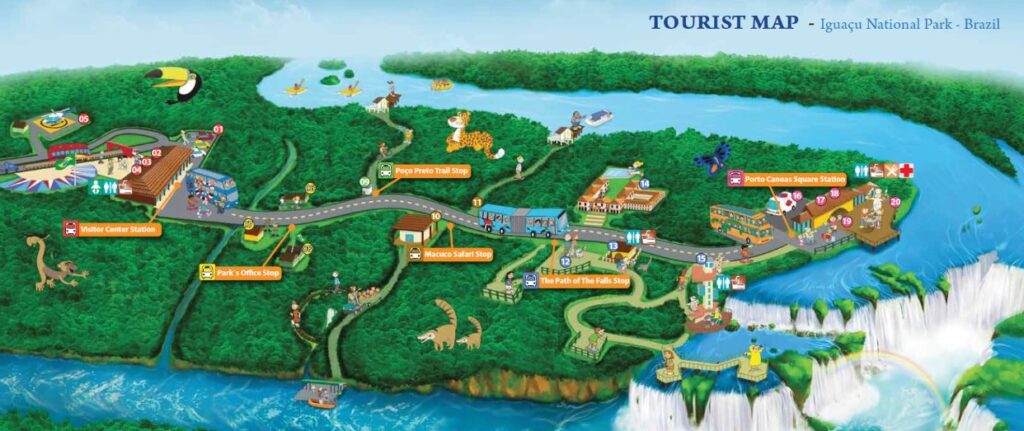
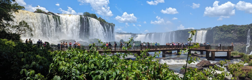
The semicircular waterfall is a bit over 80 m high and 2,700 m in diameter and is made up of many cascades producing vast sprays of water, it is one of the most spectacular waterfalls in the world. At one point along the edge of Iguacu Falls, an observer can stand and be surrounded by 260 degrees of waterfalls.
Around 80% of the falls are on the Argentinian side, while the remaining 20% is on the Brazilian side. The falls are made up of 275 individual waterfalls that drop water anywhere between 60 to 82 meters (depending on what they hit on the way down). In the local language (Guarani/Tupi) the word Iguazu means “big water”.
Some Animals
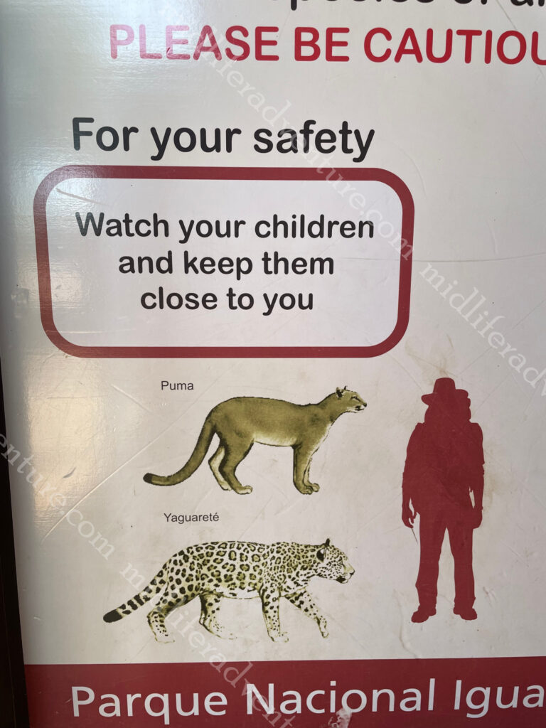
Both the Brazilian and Argentinian sides of the border are surrounded by sub-tropical rainforest National Parks. The parks are home to over 2,000 species of plants, an impressive array of birds, thousands of butterflies and mammals such as tapirs, jaguars and monkeys (not that you are likely to see anything resembling a jaguar or puma in the tourist areas). And a new one for us was the Coati.


When listening to the tourist spiel on the bus they kept saying don’t feed the monkeys or the Coatis. We heard Coyotes and were perplexed. As it turns out, a coati is a scavenging racoon-type thingy, that is overly inquisitive, a touch aggressive and not at all afraid of humans.


So much so that after examining one of the trails, we opened our backpack to get a drink of water and the nearest Coati made a beeline towards us looking for food. We grabbed the bag and moved away from the biting, scratching oversized rat-looking thing. Reading about them afterwards, if you leave your bag they will open it and ransack the food and beverages within.
The Brazilian Side – Foz do Iguacu
OK, so our first entry was into the Brazilian side and it must be said that Brazil is by far the most expensive of these three countries.
Our day trip to go to the falls cost us about $400 to do, but it did include a car to and from the park, all fees and even saw us on a boat ride getting soaked by the waters of the Iguaçu.
Looking on the map we got soaked by the Salto dos Mosqueteros and Salto Tres Mosqueteros.


Foz do Iguacu is a city of around 250-300,000 people and as you would expect, the majority of the town is geared around the falls. The tourism and transport sector is strong and the restaurants, shows and cafes also thrive here.
Anyway back to our trip, our car took us to the National Park where we hopped a bus for a 20 minute or so ride to the boat ride. From here we hopped an electric train thing (buggies pulled by a big golf cart) through the forest so as not to disturb the animals, where we got delivered at a rainforest walk that saw us hiking the last kilometer or so to get to the river for the boat ride.


From here you got changed (you were to be going under the waterfall and would be soaked) and left all your important gear in the lockers (for an additional fee). Then it was onto the short funicular down to the pontoons and onto one of the waiting boats. And this is where the fun starts. A quick 10 minutes or so up the river, through a series of about 4-6 rapids and all of a sudden the forest open up to expose the Argentinian side of the falls.


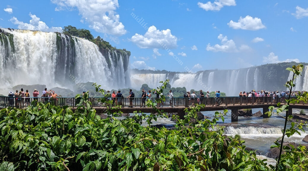
While only 20% of the falls are on the Brazilian side the best views can be found from the Brazil side as you get to see all of the falls. In addition to this, you actually get to walk out onto platforms over the bottom of the falls and get wet from the spray (more about this later).
After the boat ride (and soaking) you go back to dry off, and get your things before taking a petrol jeep up the hill (too steep for the golf buggy) where you meet the electric cart, back through the forest and out onto the road again to wait for the next bus to take you to the next viewing point.
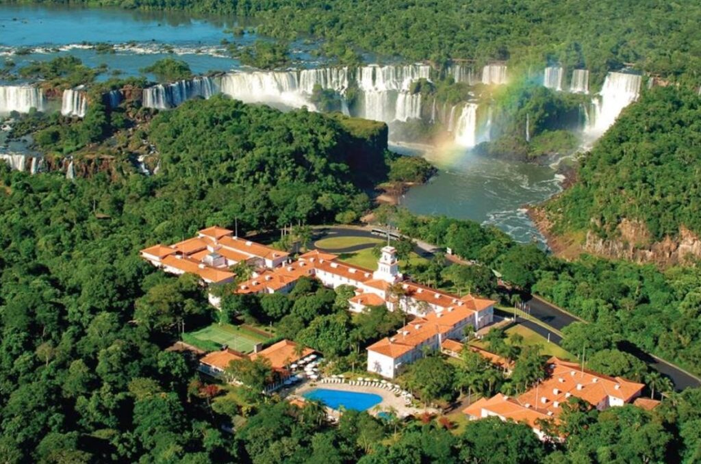
And what a spot to drop you off. Outside the Hotel das Cataratas, the closest hotels to the falls on the Brazilian side. Sadly our budget did not stretch to this.
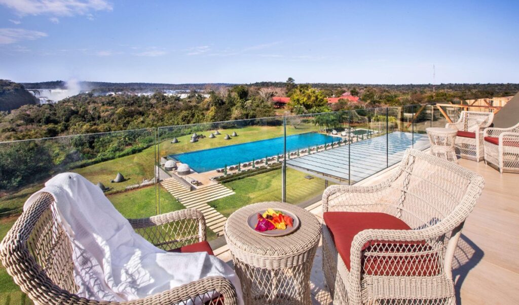
Not to be outdone, the Argentine side also has the Gran Meliá Iguazú. Needless to say, we didn’t stay here either.
From this point, you head down to a cliffside nature walk along the river where you get amazing photos of the Argentinian side (without the bumping and thumping of a moving boat). To say that this is amazing is an absolute understatement. Everywhere you look the angle changes and they are all stunning. Our photographs just kept clicking the whole time as every sight seemed somehow different.


This walk along the cliff takes you up and down stairs, along dodgy paths and will have your calves and thighs burning as this is a day that you will easily get your 10 thousand steps up (and many of them vertical).
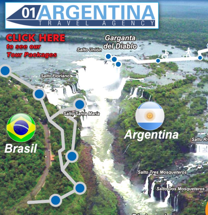
The path eventually spits you our at Salto Santa Maria which is the base of what would be considered the main falls. This area has a walkway over the top of the water and has amazing views of the biggest attraction, the devils throat (Garganta Del Diablo).
The legend
And of course, like any great natural feature, there has to be a local legend to explain its existence. In this instance the serpent god (M’Boi) was considered the God of the waters, protector of the river, nature and son of Tupã, the God of the Indians. But M’Boi fell in love with a local girl (Naipi) who was already engaged. He demanded that instead of marrying her fiancé (Taruba), she be sacrificed to him.

They decided to run away but M’Boi chased them and in a rage sliced the river, creating the falls and condemning the lovers.
Eventually, he transformed Naipi into a giant stone and Taruba into a tree on the other side of the falls, so that they would forever be apart.
A rainbow often forms from Taruba’s tree on the Brazilian side to Naipa’s rock on the Argentine side, which is said to symbolise their love.
However, the Serpent God is believed to still jealously watch the lovers from one of the deepest parts of the river, which is also known as the Devil’s Throat. Approximately one million litres of water per second is known to flow over the falls at the Devil’s Throat (or Devil’s Cauldron).
The Devil’s Throat is the most impressive of all of the 270 odd falls. It is a U-shaped cataract which has 14 falls plunging more than 350 feet. About half of the river’s flow falls into a long and narrow chasm. The canyon is 80–90 m wide and 70–80 m deep. It is estimated (by wiki) that almost 13 million litres of water flow over the falls every minute.


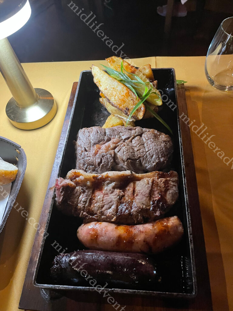
Having monstered the falls on the Brazilian side we had a night of Brazilian BBQ (cos you gotta do that) where too much meat is never enough. What we learned was that an all you can eat BBQ might have been fine in your 20’s, but in your 50’s it is too much of a stretch. After this we got ready for the ride over to the Argentinian side to check it out from over there.


Crossing the border
Going from Foz do Iguacu to Puerto Iguazu is a 15km ride that involves crossing a land border. There are several ways to do it and the price ranges from $7 (for both of us) to well over $100, depending upon how cheap, easy, quick and efficient you want it to be. As it turns out we chose the cheap, slow and completely inefficient option.
As we are dodgy cheap backpackers, the $100+ private car was not an option (although after our nightmare probably should have been) so we grabbed ourselves an Uber to the local bus station. Here we stuffed around for about 20-30 minutes trying to work out what bus to catch. Having found the bus we needed we paid $7 and waited in the heat for the next 45 minutes for our bus (they come every 30 mins according to the spiel).
Once on we rode for about 10-15 minutes when we got kicked off to clear Brazilian immigration. The information was to clear immigration and get on the next bus with the same ticket.
After taking about 6 minutes to clear immigration, we saw the next bus departing (I guess he was early). So we sat in the sun for another 45 minutes waiting for the next bus (which did not stop) and then another 15 minutes until another arrived to drive us about 2km so we could clear the Argentinian Immigration.
Everybody off the bus and then out the other side (at least this time the bus driver waited for everybody). The next bus arrived at the same time and they consolidated the two buses taking us the next 10-15 minutes into the town of Puerto Iguazu.
Thankfully, our hostel was a short walk (in 37-degree heat) and we settled in and hid in the air conditioning until after 4 pm when the money exchange opened.
Side Note
Usually when travelling the use of credit or debit cards is the king. In every country, using a money exchanger at the airport (Travelex comes to mind) is almost always the worst and most expensive way to exchange your money. In some nations where cash is preferred (notably in Asia) getting the cash is usually best done from an ATM and then spent in the small stalls and trinket shops that deal solely in cash.
But not in Argentina. In Argentina there are two rates of currency exchange, the official one (where $1USD=827AP) and the black market one.
The black market rate is much higher (20-25%) and often changes based on the type of bill you swap out (eg a $50 bill will change at 940 while a $100 will change at 980).
This rate goes up the further you move away from Buenos Aires too. I got 940 in Buenos Aires but got 1050 on day one in in Puerto Iguazu and 1102 on day three (all considerably better than the official rate in the low 800’s).
This means that a meal for two costing 50,000 pesos (a very expensive and lavish meal with drinks) would cost you $93 Australian if you paid by credit card or only $69 Aussie if you paid cash.
Sadly, the bank notes come to you in 1000’s. So changing out money on the streets sees you walking around with huge wads of essentially $1 bills.
The Argentine economy is almost single-handedly ensuring the future of the rubber band industry.
The Argentinian Side – Puerto Iguazu
The Argentinian side of Iguazu is way cheaper than the Brazilian side, for accommodation, food, drinks, ticket prices and tours. If we had known this differential beforehand we would have scheduled our visit considerably more different (but more about this later).
Our first meal in town was not our usual cheap and cheerful but a flash joint with table cloths and table lighting. The night before we had done the Brazilian BBQ and were in a meat coma and then we found the Argentinian Parrilla (basically the same thing but cheaper).


The next morning it was off to the falls from the Argentinian side. Thankfully this was much cheaper and much easier. Rather than the $400 that we paid the day before, we paid $52. This did omit the private driver and boat ride but included the bus rides to and from the National Park and all entrance fees.
Fair warning, the Argentinian side does have even more walking than the Brazilian side. But it is considerably flatter, with fewer hills, less stairs and is on better paths. There is a train to take you some of the way, but there will be much walking.


Iguazu Falls is one of the natural wonders of the world, and for good reason. Wandering its grounds is pretty special and the attention paid towards protecting the National park is excellent. As you head through there is a myriad of boardwalks, pathways, platforms steering you through and allowing you to discover the waterfalls pouring every which way, while also stopping the hoards destroying nature.
Bring a rainforest there are critters. So using the best of safety concerns the Argentinians have put up a sign that basically translates to…don’t be a dickhead.
The rest it up to you.
I am very ok with this sort of approach to stupidity.
Because the Iguazu Falls straddles the border there are very different vantage points and views from either side. And all of them are gorgeous.


The Argentinian side has two main trails, the upper and the lower. There used to be an extra train stop that took you to the a platform above the Devil’s Throat but major rains and flooding took out the platform and it is unlikely to be reopened. The upper trail takes you up high and you get to see the top of the falls (which really isn’t that interesting as you see a cliff with water running over it).


The bottom trail however offers the best views with the water falling and cascading and the rainbows and all of those things that that you expect and come to see when you head to a waterfall.


After our blitz around the falls, we were off to another Parrilla for yet another meat fest. We really tried to order vegetables, but meat really is king here. My favourite part was that they served my 740ml beer in a high hat on ice. We got the mixes seafood entree and followed it with a 900gram tomahawk steak to share. While we may have been at a flash restaurant, my inner caveman came out and I gnawed upon that bone like my life depended on it. Something that my wife was more than eager to immortalise on film.


The best way to do it
Having seen the falls from both sides we felt that we were well placed to offer our insights and suggestions of how best to go about this if we were to do it again.
The bus transport from Argentina is efficient, reliable, clean, cheap and airconditioned. The Brazilian side however is woefully inefficient. But from Puerto Iguazu, there is also buses that will take in the Brazilian side without having to deal with buses taking off and leaving you to wait.


Point number one…you need to see both sides. It is amazing and every view is different and all angles are amazing. But the Brazilian side is absolutely the best, but it is also the most expensive (not prohibitively though so don’t be too scared). If you wanted the 5 star experience you could still do it on the Brazil side without destroying a budget.
So if we had our time over we would have stayed the 3-4 days on the Argentinian Side (saving money on both food and accommodation) and visited the Argentinian side first. We would have done the boat ride from the Argentina side, saved a ton of money and got wet at exactly the same falls.
The next day we would get up early and catch the Argentinian bus over to Brazil and do that side of the waterfalls. Over here you get better views (even if farther away) of 80% of the falls and you also get up close and personal with the remaining 20%.


But any way that you choose to see the Iguazu (Iguacu) Falls I am certain that you will not be disappointed.