Copenhagen is the capital of Denmark, with a population of around 1.4 million (3.8 in the greater Copenhagen area). It sits on the islands of Zealand and Amager. It regularly gets voted in the top 5 most livable cities and the Danes always rank highly on the world’s happiest people.
Copenhagen’s 1,000 year history is reflected in the buildings, museums, sights and attractions that you come across. But in addition to this is the modern infrastructure, innovation and daring architecture that keep it high on the happiness scale.
Copenhagen started as a Viking fishing village back in the 10th century and became the capital of Denmark in the early 15th century.
Denmark has the world’s oldest monarchy. The current reigning Queen Margrethe II, counts legendary Viking King Gorm the Old (900-958 AD) as one of her ancestors. Royalty is present everywhere in Copenhagen mostly manifesting in the many palaces and regal buildings built by kings and queens throughout the centuries.
Jill could not have put our hotel any closer to the railway station if she had tried.
A funky little joint, directly opposite the station, would make our early morning departure quick and painless.
In the other direction was the historic Tivoli Gardens.
Tivoli Gardens is an amusement park in the middle of town. It first opened its doors on 15 August 1843.
It is the second oldest amusement park in the world (the oldest is Dyrehavsbakken – also in Denmark).
Built in 1914 it has one of the world’s oldest wooden roller coasters that is still operating today.
The area around is known as the Strøget, which is one of Europe’s longest pedestrian streets, running from City Hall Square to Kongens Nytorv (The King’s New Square). It is the city’s main shopping area.
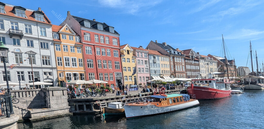
Nyhavn is one of Copenhagen’s most iconic sights, with a row of colourful houses that are now restaurants and bars.
Originally it was a commercial port where ships from all over the world would dock, and was packed with sailors visiting its pubs, alehouses and ladies of pleasure.
The Danish fairy-tale writer Hans Christian Andersen was most famous for his fairy tales even though he wrote novels, poems, plays and travel articles.
He used to live on Nyhavn in number 20, where he wrote the fairy-tales ‘The Tinderbox’, ‘Little Claus and Big Claus’, and ‘The Princess and the Pea’. He then lived for twenty years in number 67 and for two more years in number 18.
As you pop out near the major canal you find yourself at the the first ever museum in Denmark. Now the Thorvaldsen Museum (displaying the works of Bertel Thorvaldsen) when it opened in 1848 its halls displayed mostly sculptures.
Charlottenborg Palace is a large mansion that was originally built as a residence but has served as the base of the Royal Danish Academy of Fine Arts since 1754.
Christiansborg Palace is a former palace and now government building in central Copenhagen. now houses the Danish Parliament, Prime Ministers office, the Supreme Court, and the Ministry of State. The Great Hall is the most imposing room in the palace and is where you will find Queen Margrethe II’s tapestries.
The equestrian statue of Christian V on horseback was raised in 1688 to celebrate the king who laid out the area.
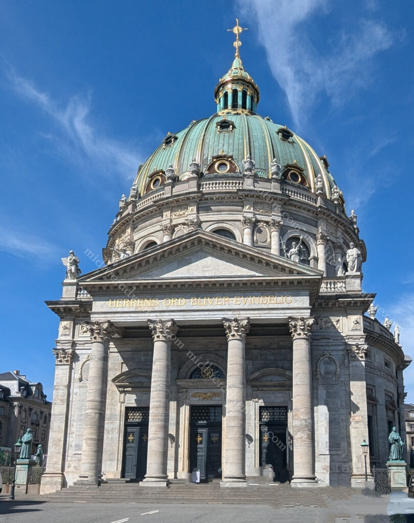
Frederik’s Church, commonly known as the Marble Church sits due west of the Amalienborg Palace and forms the focal point of the Frederiksstaden district.
It is an Evangelical Lutheran church, the foundation stone was laid on October 31, 1749 but it stood as a ruin for nearly 150 years until it was finally finished until 1894.
St. Alexander Nevsky Russian Orthodox Church is the only Russian Orthodox church in Copenhagen. It was built by the between 1881 and 1883, prompted by Princess Dagmar of Denmark’s marriage to Alexander Alexandrovich.
They later ascended to the Russian throne as Tsar Alexander III of Russia and Tsaritsa Maria Feodorovna.
Around the corner you find yourself at the Design museum. Originally the first public hospital in Denmark the museum now offers displays of decorative art, crafts, and industrial designs from the late Middle Ages up to the present.
The National Museum of Denmark showcases everything from Viking treasure, the 3,000 year old Sun Chariot, the Egtved girl’s grave through to Egyptian mummies and renaissance art.
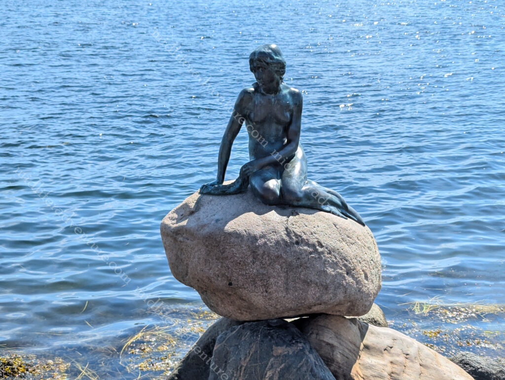
No trip to Copenhagen is complete without going to see the Little Mermaid. But to get there you have to take a fair hike through Kastellet. This one time Citadel is now a public park but still houses one of the best preserved fortresses in Northern Europe. It is shaped like a pentagon with bastions at its corners. There are a number of buildings located within the grounds including the Citadel Church as well as a windmill and various military buildings.
The Little Mermaid is a bronze statue depicting a mermaid becoming human. It is based on the fairy tale by Hans Christian Andersen.
It is a small and unimposing statue and has been a Copenhagen icon since its unveiling in 1913.
Rosenborg Castle sits in the centre of Copenhagen and was originally built as a country summerhouse in 1606-1607. It sits in the middle of the King’s Garden and is home to the Danish Crown Jewels, Crown Regalia, and gems. The park was created by King Christian IV in the early 1600s for parties and frivolities. Today the park is open to the public.
Amalienborg Palace Frederik VIII’s Palace was built during 1750-60 for Baron Joachim Brockdorff. Today the palace is The Royal Family’s private residence.
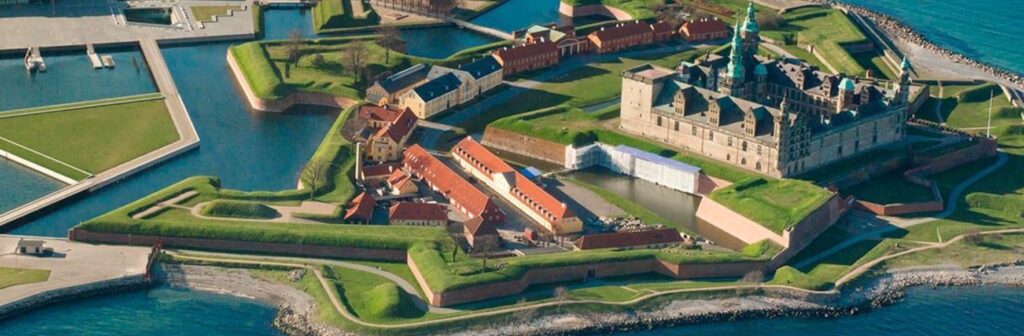
An hour outside of town you will find Kronborg Castle, ‘home’ to Shakespeare’s Hamlet.
The first castle on this spot was built in the 1420s. Ships passing into the Baltic Sea paid tolls at Kronborg Castle and Helsingør was once one of the most important towns in Europe.
The modern castle has the same dimensions as when they enlarged the castle (upwards), the old one was not torn down. They just built on top of it.
Deep under the castle you’ll meet Holger the Dane (Holger Danske), an imposing stone statue. Holger the Dane is a legendary figure in Danish culture and according to legend, if Denmark is ever in trouble, he’ll waken from his rock throne under Helsingør and defend her.
Our trip to Copenhagen was too short. There is so much history and so much to see and do, you really need much more time than we had available. The problem with this is that Copenhagen is brutally expensive. Accommodation, food and drink will seriously damage the wallet. It is lovely to see but I am not entirely sure that either of us would put this (or most of Scandinavia to be honest) on our must return list. They were all nice and interesting enough, but it may just be a been there done that tick for far northern Europe.
Ok so two of my closest mates (Jimmy and Angelo) had both spent the preceding week and month respectively in Sweden and both raved about how good it was.
My mate Angelo has been coming for years and catching up with some local friends and Jimmy was catching up with family.
So Sweden got quite the buildup before we had even arrived therefore our expectations were high.
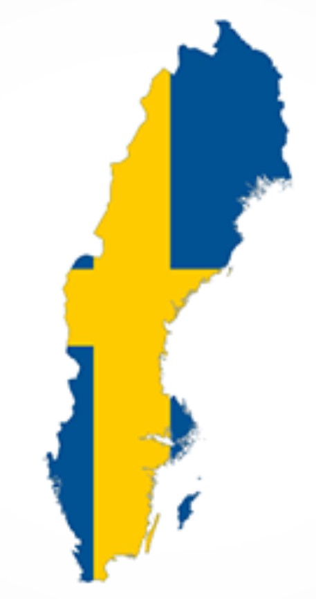
At 450,295 square kilometres and a population of a bit over 10.6 million, Sweden is the largest Nordic country and the fifth-largest country in Europe. Sweden has been inhabited since prehistoric times, c. 12,000 BC. A unified Swedish state was established during the 10th century and in 1397, Sweden joined Norway and Denmark to form the Scandinavian Kalmar Union.
The Swedish Viking Age lasted from the eighth to the eleventh century with Swedish Vikings travelling east and south, going to Finland, Estonia, the Baltic countries, Russia, Belarus and Ukraine. Stockholm is the capital and Gothenburg is the home of Volvo.
Stockholm
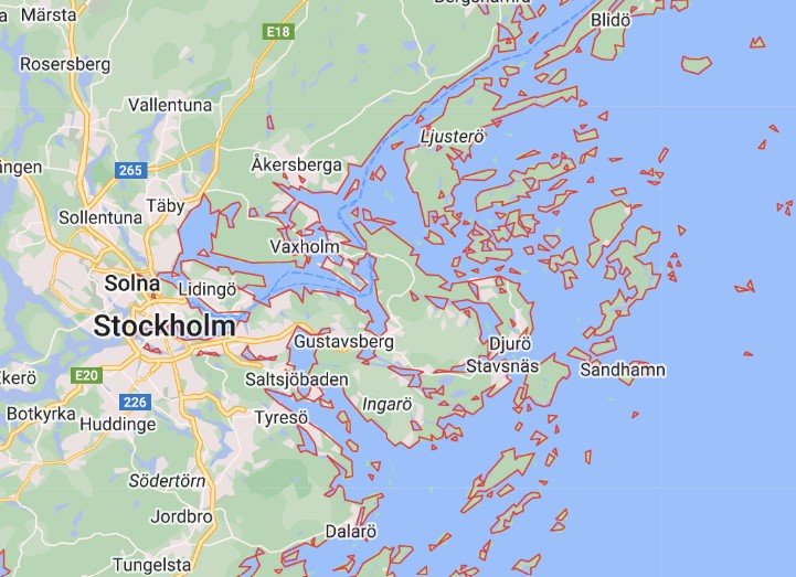
The city of Stockholm is situated on fourteen islands and on the banks of the archipelago where Lake Mälaren meets the Baltic Sea.
Our entry to Sweden was on an overnight ferry (more like a cruise ship) from Finland. This meant that we sailed in past some of the 267,570 islands that Sweden has to offer.
This made for a pretty spectacular way to enter a country.
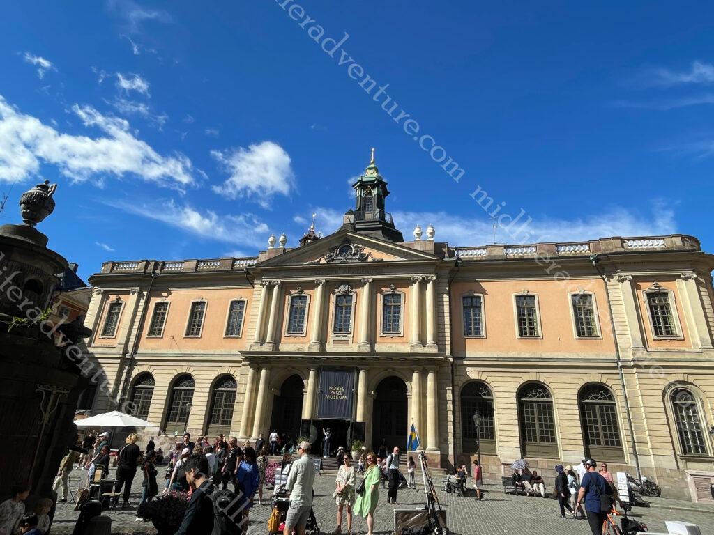
After landing we grabbed a car from the docks to our hotel, which was quite literally right next door to the central railway station (we would leave by train). Once settled we headed straight for a flea market that we had passed on the drive in. As it turned out, the market was being held in the square in front of the Stockholm concert house (Konserthuset) which was built after WWI. Since 1926, the Nobel Prize in medicine, physics, chemistry and literature has been awarded (on 10 December each year) in this concert hall.
The flea market was more flea than market, so we took some happy snaps and continued our journey. This saw us getting to Sergels torg a public square with a sunken pedestrian plaza and a distinctive grey and white triangular design. As we tend to do, we were wandering in the general direction of the palace but got distracted by funky looking buildings. The first that we saw was Saint Jacob’s Church.
Around the corner and we were in the Kungstradgarden, a long and impressive greenspace linking the city heart to the water.
The Kungliga Opera House that is home to the Royal Swedish Opera and the ballet company. As seems to be the way, the entire side facing the water was covered in scaffolding. But as in Helsinki, they did leave the front relatively clear.
As you cross the bridge you find yourself on a tiny little island and a park called the Riksplan, a public park with the Swedish Parliament house (Riksdagshuset) on your right.
And directly across from that is Gamla stan, the old part of the city that holds important things like the Royal Palace and Museums (Kungliga Slottet). We arrived at about 1pm to see hundreds of people starting to mass at the gates. A snappy google search told us that the changing of the guard would take place at quarter past. We started to hang about, but about three tour bus loads later and we decided to walk away.
Storkyrkan Cathedral is the oldest church in Stockholm and lies in the centre of Gamla stan, between the Palace and Stortorget, (the old main square of Stockholm).
It was built in the 13th century and currently serves as the seat of the Bishop of Stockholm.
Also on the Gamla Stan Island you will find the Nobel Prize Museum, a small museum with vast content.
Just across from Gamla Stan is another small island that is home to the Riddarholmen, the church of the former medieval Greyfriars Monastery. It is the largest church in Sweden and serves as the final resting place of most Swedish monarchs. We have seen quite the number of churches over the years, this one is up there with the best.
With Jimmy having just left Sweden, he talked up a couple of beverages that he rated particularly highly. So based on his recommendation we headed to a venue, ordered his suggestions, and then tinkered with some others. Fair enough to say that they were not terrible and we slowly sipped our way through the afternoon.
Having blitzed the old town area all that was really left was to wander the streets and check out the mix between old and new that Stockholm has to offer. It was pretty similar to Helsinki, but somehow felt so much more interesting. I cannot explain why but the feel here in Stockholm was much more welcoming.
Gothenburg
Gothenburg is the second-largest city in Sweden, with a population of about 600,000 and 1.1 million in the broader metro area. The city isn’t actually called Gothenburg, in Swedish the city is named Göteborg, roughly pronounced yaw-ta-bore(g). Founded in 1621 it quickly became a major commercial fishing and shipbuilding hub, and later the birthplace of Volvo.
It sits on the west coast of Sweden and has been ranked as the world’s most sustainable city for the last six years running. Gothenburg was the first city in the world to issue green bonds to stimulate investment in solutions to climate change. Almost all the city’s hotels are eco-certified and plans to develop a zero-emissions transport zone in the downtown district are well underway.
Jönköping is located on the highway between Stockholm and Gothenburg. The tourist blurb suggests that there is plenty to do around Jönköping. This includes things like the lake Vättern Biosphere Reserve, fishing, camping, hiking/biking trails, kayaking, and of course there is the safety match museum.
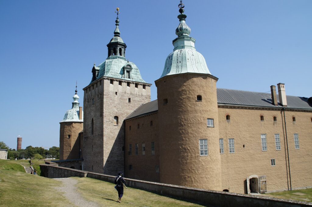
Kalmar is by the Baltic Sea near the Danish border and is surrounded by water. It was a fortified city and a stronghold for royal power (13th to the 17th centuries). At the center is the Kalmar castle, which was used to defend Sweden against invasions.
Älmhult is the home of Ikea. It is a city/town of about 9,000 and it houses both the Ikea Hotel and the museum. The museum is massive and showcases the design and history of Ikea. while the hotel is the only place you can stay in a room completely furnished with 100% Ikea products. They even have price tags and information about where to find them in the store!
The most important thing that we learned in all of out time in Sweden, is that Australians pronounce the most famous Swedish store (Ikea) incorrectly.
We typically call it (eye kee ah) but after much consultation we have learned that it is actually pronounced (ick ee ah).
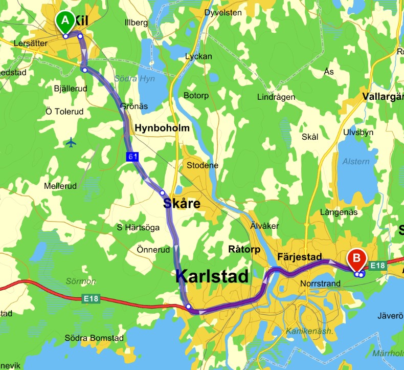
Leaving Sweden ended up being quite the adventure, it wasn’t meant to be it just happened that way. Our day started at about 5am with a short (about 100m) walk to the central train station where we waited and boarded our fast train towards Oslo in Norway. All went swimmingly for the first couple of hours with some stunning Swedish countryside to be taken in.
Until the train ground to a halt in the town of Valsviken. Apparently there was an issue at the next stop (Karlstad) which meant that no train (from either direction) could enter. This meant that we all got kicked off the train and milled about at the wrong station waiting for buses to come and get us to drive us to the station that they couldn’t use.
Once at the broken station we then got ferried to the next town of Kil where we met up with the similar train going in the opposite direction. Apparently they had all been similarly dumped and bused and were wending their way to the train that we had just abandoned.
While it all seems fairly innocuous, the communication throughout was less than stellar and there was much milling about in the cold and the wind while confusion reigned supreme. Hundreds of people, not enough buses, poor communication and at least 7 languages in play made for an entertaining few hour delay and drama.
On the up side, we got to see even more of the amazing Swedish countryside and lakes. The place really is very pretty.
Sweden had a really nice feel to it. By all accounts, the real value of Sweden is not to be found in town but in nature. There are countless national parks and nature reserves in Sweden along with four biosphere reserves. A Biosphere reserves is an ecosystem of special scientific and natural interest that are left undisturbed. In addition to this there are the many rivers and lakes that we drove past that are visually just stunning. So I guess we have a reason to return.
The area that is now Finland was settled around 8,500 BC during the Stone Age towards the end of the last glacial period. The artefacts the first settlers left behind present characteristics that are shared with those found in Estonia, Russia, and Norway.
Finland covers an area of 338,145 square kilometres (130,559 sq mi)[4] and has a population of 5.6 million.
In 1906, Finland became the first European state to grant universal suffrage, and the first in the world to give all adult citizens the right to run for public office.
The nation remained a largely agricultural country until the 1950s. After World War II, it industrialised quickly and established an advanced economy. It became a member of the EU in 1995, the Eurozone in 1999, and NATO in 2023.
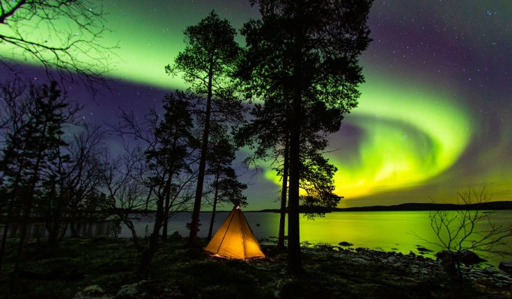
Finland in the summer months – the sun doesn’t set at all in the northernmost parts of the country, hence the nickname “The Land of the Midnight Sun.” In the winter, the opposite happens, and the sun disappears for months. This time is called “kaamos”.
And – if you’re lucky – the Autumn and Spring may bring the colourful Northern Lights (photo from visitfinland.com).
And according to the WHO (World Health Organisation) Finland has the best air quality in the world.
Getting here
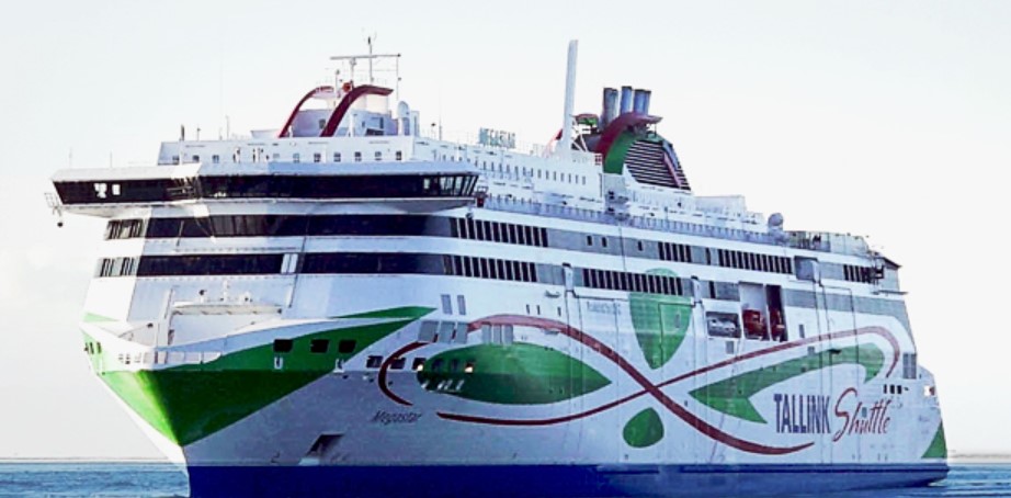
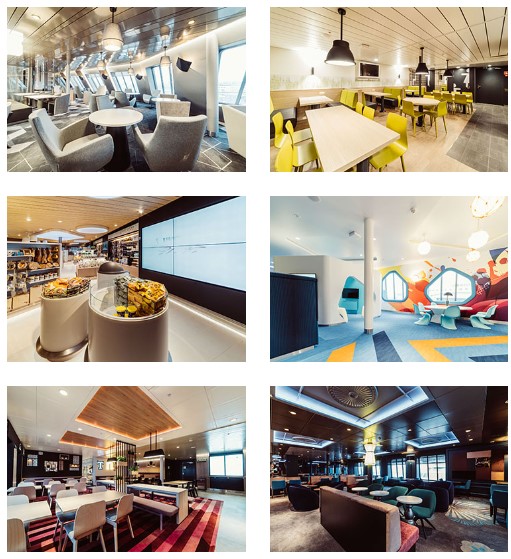
Our trip to Finland from Estonia was on the ferry. I must be honest and say that the idea of a ferry was not all that appealing. But on arrival I was met by more of a cruise ship than a ferry. The modern European ferries make the Australian ferry options look absolutely prehistoric. Our trip was on the Tallink Megastar.
The Megastar is the newest ship in the Tallink fleet and has been operating since 2017. The 212 metre vessel can hold 2800 passengers and reach speeds of 27 knots.
It has restaurants, bars, the largest mall on the Baltic Sea and a 2,800 square meter Superstore (think Myers) that is a fully stocked.
Add to this a huge duty free shop where you can get spirits, wines, beer, cigarettes, sweets, cosmetics and perfumes.
The garage area has a capacity of 150 vehicles.
The ride only took 2 hours and there was quite literally not a wave to be seen. The Baltic Sea (at least when we were there) was a millpond. Long story short, my fears of the ferry were unfounded and in reality this is the best and most relaxing way possible to get around up here.
Helsinki
Helsinki is the capital of Finland with a population a bit over 600 thousand. I will state right now that the beer and the local food was absolutely the lowlight of our time here in Finland. Both the price and the taste left us both unimpressed. We did find a Syrian restaurant that saved us, but the local fare on offer was not great.
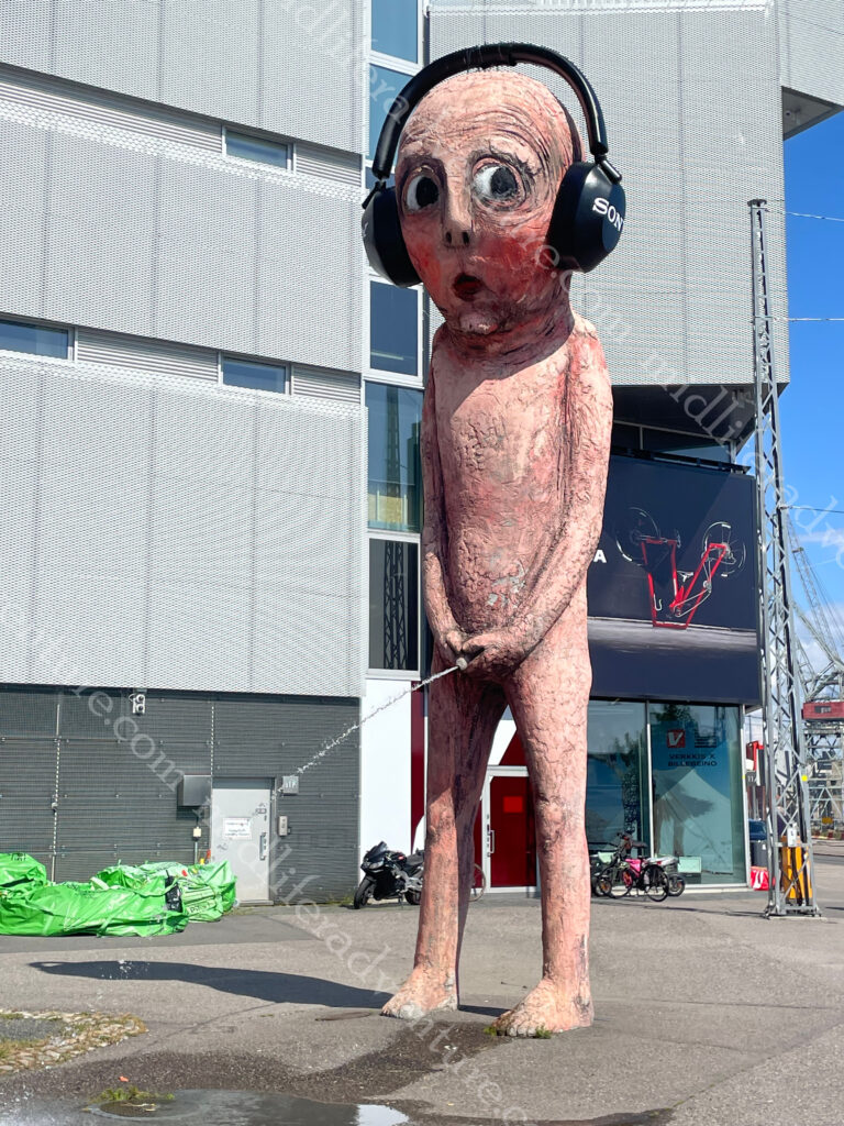
Our introduction to Helsinki was when we left the port and walked about a kilometer away to get our Bolt car without the harassment of the local cab drivers. Here is where we found the Bad Boy. It is a pink 8.5 metre sculpture made of concrete that weighs in at about seven and a half tons. And it is of a boy pissing. The water flow in the sculpture is heated so the boy can urinate all year round, even in winter.
It was was originally ordered as part of a public art festival in Sweden, where it urinated into a river in a park.
It then moved to Market Square in Helsinki where it urinated into the ocean in front of the Presidential Palace.
It most recently moved to in front of an electronics store, where it acquired a set of headphones.
There is a HOHO bus in Helsinki, but it is €34 each, and the town centre and loop really isn’t that big and is easily walkable. The Mannerheimintie is the central avenue that runs through the heart of the capital. Unlike the old towns of the Baltics, Helsinki is a very modern city.
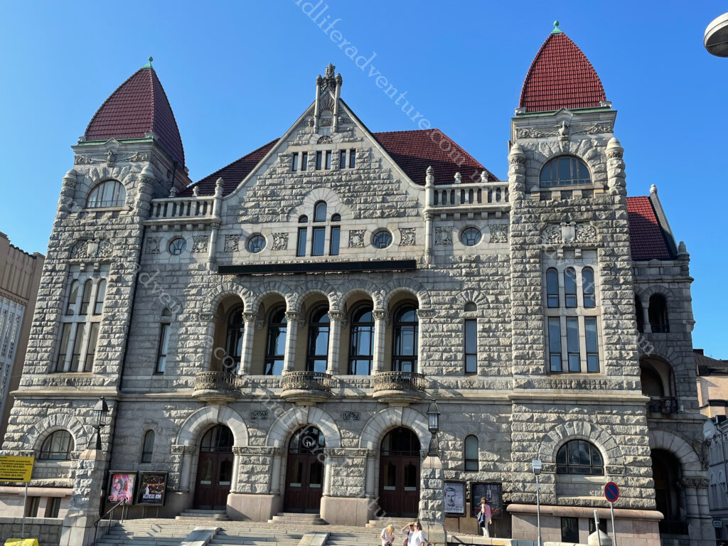
But we were here and it was time to explore. Our wander towards town saw us looking at some interesting looking buildings, nice parks on a cool and pleasant day in the heart of town. Once we got to the circular Swedish Theatre we were in the heart of it.
Modern blocks, full of rows of shops and shopping malls to rival any modern city on the planet. There was the odd glimpse towards something vaguely historical, but for the most part it was just a modern city. The central railway station signalled the start of a bit more character. The railway tracks were built in the 1860s an the granite clad station in 1919. The building is known for its clock tower and the Lyhdynkantajat (“The Lantern Bearers”).
Just down the road from the train station you come across Rautatientori square and the the Finnish National Theatre. founded in 1872, is the oldest Finnish-language professional theatre in the country.
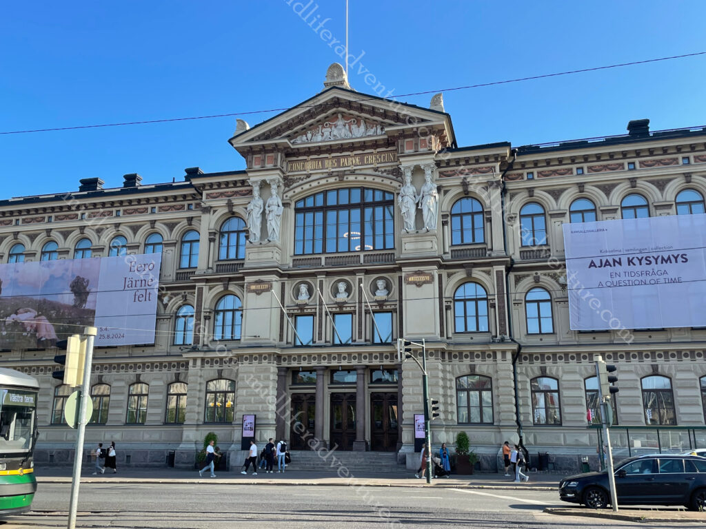
Across the road you find the Ateneum, which is the major Art museum in Helsinki. It is one of the three museums that forms the Finnish National Gallery.
The National Museum was closed for renovation at the time we were here. But when it is open it looks like this and it traces the Finnish history from the Stone Age to the present.
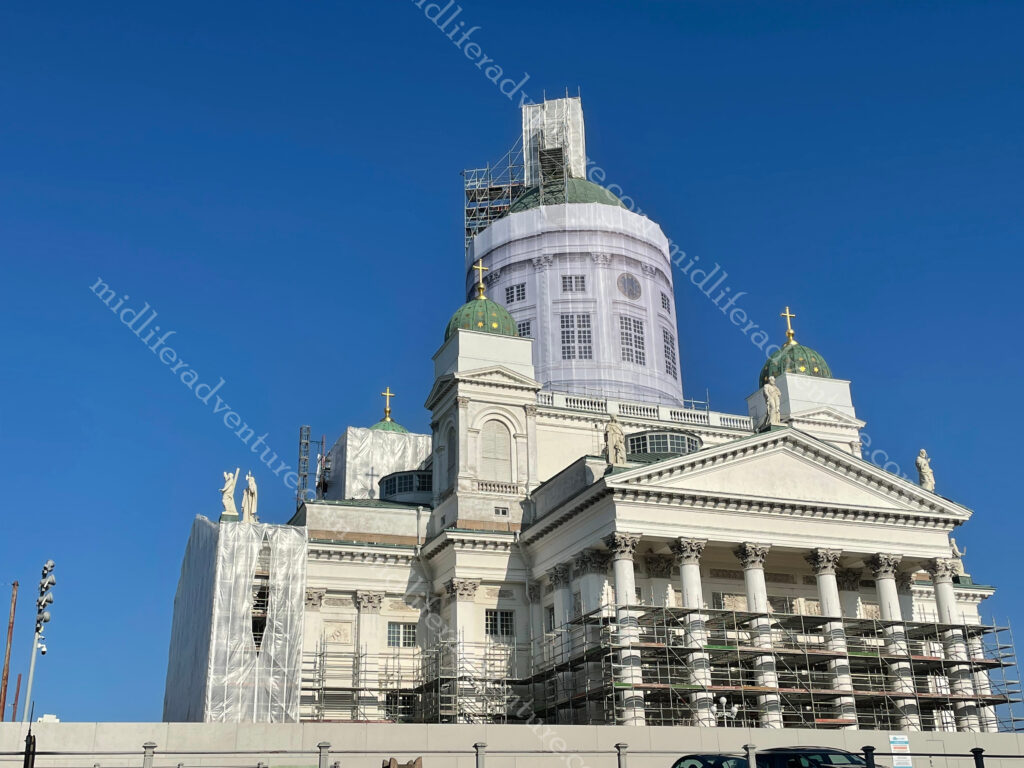
Helsinki Cathedral was one of the must do major attractions and once again, it was under construction.
The usually stunning building was covered in scaffolding.
While the main building was under renovation, they did leave one side free for photographs. Added to this the Cathedral sits on Senate Square, which is impressive enough in its own right. The square is in the oldest part of central Helsinki and is ringed by the Cathedral, the Government Palace, the main building of the University of Helsinki and the oldest building of central Helsinki (Sederholm House dating from 1757).
Having had enough for day one and walking plenty we made our way back towards our accommodation, stopping for some very poor local beers and bites on the way. The next morning a great breakfast primed us for another day of walking to explore the rest of the city. But first we headed down to the location of the open air flea market. This was clearly just a weekend thing, and after standing and scratching out heads for a while it was back to the Mannerheimintie.
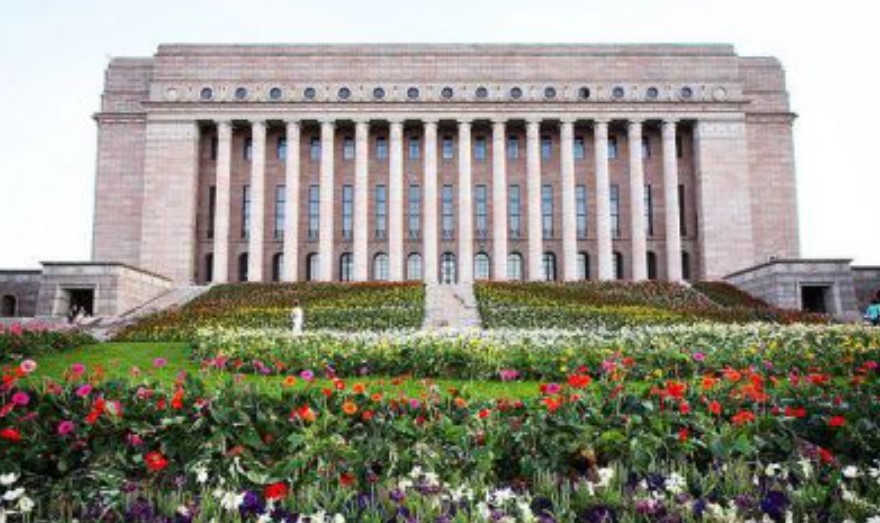
Also on Mannerheimintie you will find the Parliament house which was designed and built after WWI.
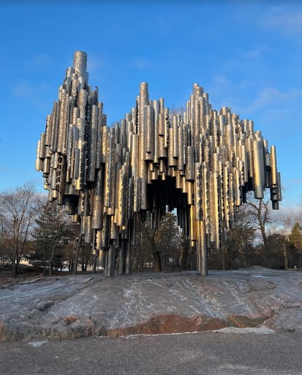
The Sibelius Monument is a park sculpture dedicated to the Finnish composer Jean Sibelius (1865–1957). It controversially looks like organ pipes, despite the composer not making music for the organ.
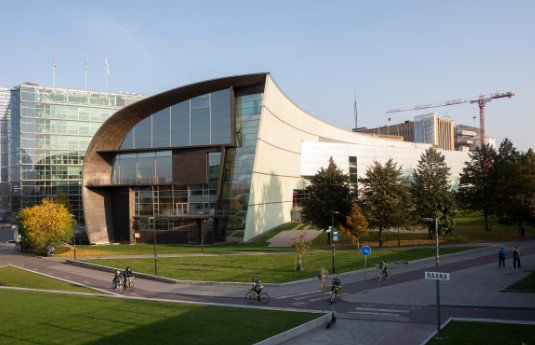
Kiasmais is a very funky location and is the home of the contemporary art museum.
At the end of the Mannerheimintie you run into the waterfront and the usual tourist fare that goes with that. A bunch of local ferries come and go, and there is a huge number of (summertime) pop up stalls to feed them and extract some money for trinkets. Add to this a Ferris wheel and a swimming pool and the place is complete.
Up the hill from the waterfront you will find the highly impressive Uspenski Cathedral. This is the largest Orthodox church in western Europe and is visited by half a million people annually. The cathedral’s size is emphasized by its location on the highest hill of the Katajanokka district. The central cupola of the cathedral is 33 meters high. The cathedral was designed by a Russian architect and was consecrated in 1868.
Suomenlinna sea fortress is a Unesco World Heritage Site located on the coast of Helsinki. It is accessible by ferry and is also a suburb of Helsinki with around 800 residents. The fortress was shaped by three historic eras when it helped to defend first Sweden, then Russia and ultimately Finland. There are six kilometres of walls, 100 cannons, exciting tunnels, and beautiful parks.
In the past, all of Finland’s houses were built of wood and usually painted red, with a few blue and yellow thrown in.
Some of these have been preserved and sit just as they did decades or centuries ago. Visiting these picturesque places is like entering a living time capsule. Within Helsinki the districts of Käpylä (about 8km north) and Vallila (about 5km northeast) will give you an opportunity to explore some of these.
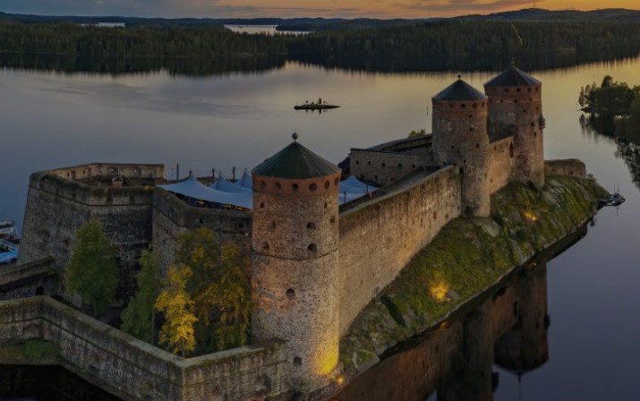
Olavinlinna Castle (also known as St. Olaf’s Castle) is one of Finland’s best known tourist sites. It was founded in 1475 and is built on an island in the Kyrönsalmi strait.
At around 400km from Helsinki we didn’t get here but it did look pretty cool. Our time in Helsinki was mixed. The town initially did not impress, but it did grow on us the more we explored. The local food and drink options were both expensive and poor, but other options (non-Finnish) were readily available and were typically better priced.
While it was perfectly nice, I don’t see either of us rushing back to Finland anytime soon. The weather was nice, the people friendly but this ticks one of those been there-done that type boxes rather than the oh my god we have to go back.
Lithuania is a developed country with a high income, advanced economy, ranking 37th in the Human Development Index (HDI) and 19th in the World Happiness Report (Australia is ranked 10 on both).
To be honest, I knew almost nothing about Lithuania before arriving here. We hopped a train from Poland and made our way to the Lithuanian capital of Vilnius. The city lies in the southeastern part of the country at the confluence of the Neres and Vilnius rivers.
Lithuanians , Poles , Jews and Belarusians have historically considered Vilnius as their cultural center. A university has been operating in Vilnius since 1579.
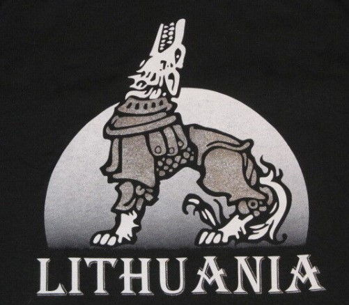
Legend of the Iron Wolf
According to the legend, centuries ago Grand Duke Gediminas, was on a hunting trip in the forests of Šventaragis valley around the mouth of the River Vilnia. When night fell, the party, feeling tired after a long and successful hunt, decided to set up camp and spend the night there. While he was asleep, Gediminas had an unusual dream in which he saw an iron wolf at the top of the mountain standing with its head raised proudly towards the moon, howling as loud as a hundred wolves.
The Duke remembered his dream and consulted the pagan priest about it. He was told that the dream was a direction to found a city among the hills.
The howling of the wolf represented the fame of the future city: that city will be the capital of Lithuanian lands, and its reputation would spread far and wide, as far as the howling of the mysterious wolf…’ So the Grand Duke Gediminas, obeying the will of gods, immediately started to build the future capital which took the name of Vilnius – from the stream of the rapid River Vilnia.
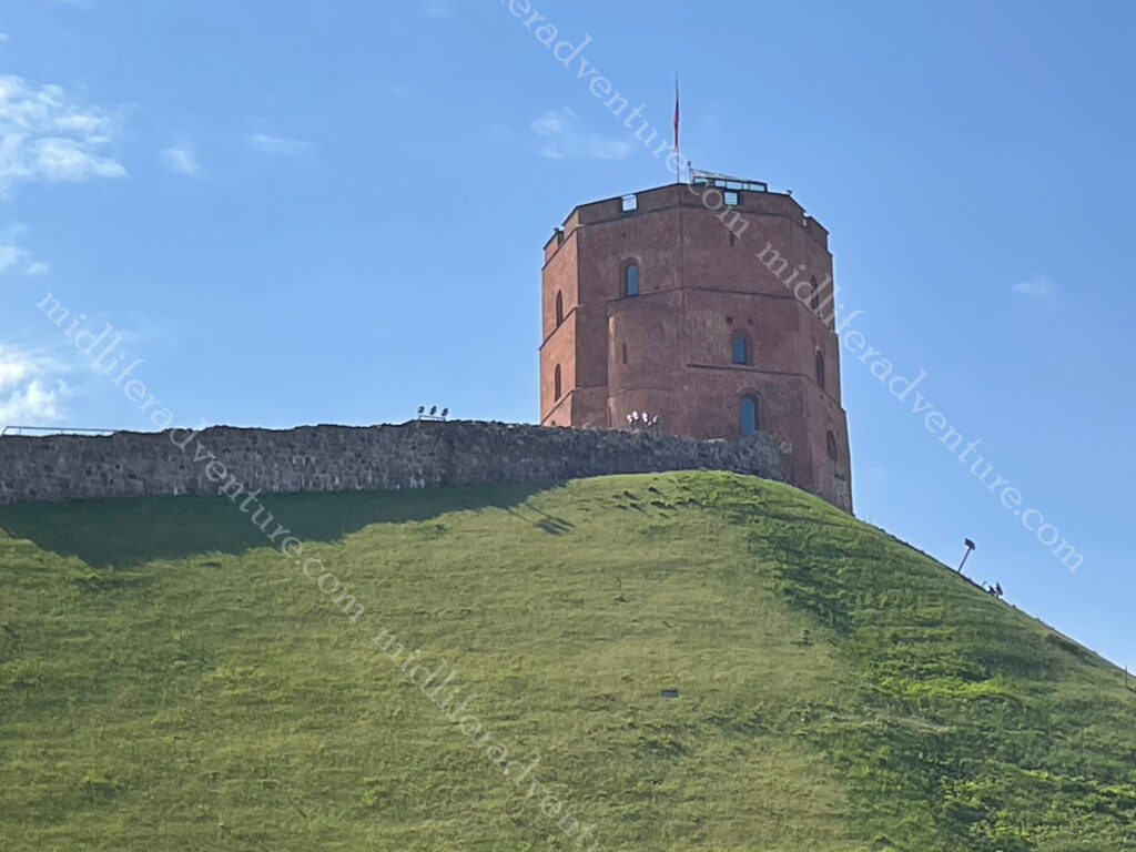
He built a fortress on the hill (Gediminas Tower) and the city of Vilnius grew up around it. You can still climb the hill and visit the Tower which provides one of the best views of this beautiful city. We however chose to pay 3 euros and use the funicular.
Hopping off the train we found ourselves in one of the cleanest and most cared for cities we have ever seen. This place was Japanese level clean and well tended for, certainly cleaner than anywhere we have ever been in Australia. Our hotel was a charming little joint, about 700m from the train station and right on the fringes of Old Town.
The oldest buildings in Vilnius were built in the 13th century. The main attraction is absolutely the Cathedral Square. It is not only the most important location in the city, but is also one of the most significant and widely known symbols of Lithuania.The square regularly hosts events such as: fairs and gatherings of townspeople, military parades, religious and official public events, attractions and large concerts, New Year’s salutes and exhibitions.
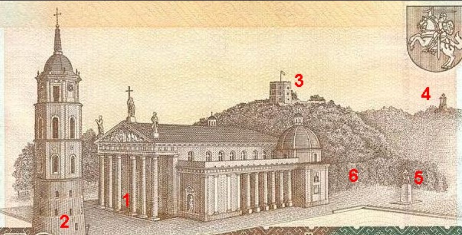
The main feature of the square is the Cathedral Basilica of St Stanislaus and St Ladislaus of Vilnius. The square was so important that it was the main feature on the 50 litas banknote (pre-euro), the layout included.
1. Vilnius Cathedral 2. Cathedral’s Belfry 3. Gediminas Tower 4. Hill of Three Crosses 5. Monument to Gediminas 6. Royal Palace
The Valdnieku (Grand Dukes) Palace , next to the Cathedral has been converted to house the history museum. Up the hill was Gediminas Castle Tower, which we took the funicular to reach the top. From here we got panoramic views over the city and surrounds.
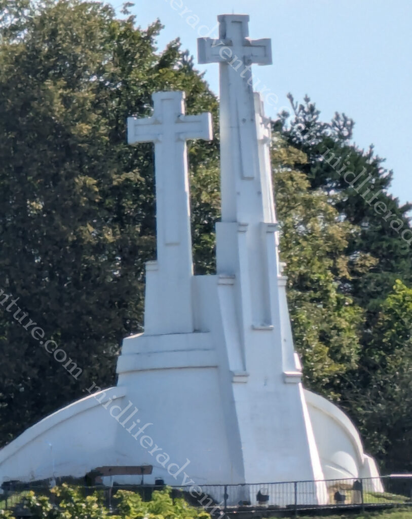
The Three Crosses memorial consists of three white reinforced concrete crosses.
The hill got its name after Franciscans died as martyrs when pagans tied them to crosses and threw them down the hill. The three crosses were erected to commemorate this event.
At the bottom of the hill and the far (back) end of the Cathedral you find yourself in the Bernadine Gardens. We did the slow meander through here on our way to St. Anne’s Church. By this time the masses of tourists had crawled out of bed and were making seeing the sights unpleasant.
In an attempt to dodge some crowds for a while we found ourselves in a local cafe/bar where Jill found her long awaited steak tartare. She had been wanting one of these since Prague, but for a variety of reasons was unable to have one up until now. So that with some zeppelins (potato/meat dumplings) washed down with an Argentinian specialty (Aperol and fresh orange juice) and a local lager.
The sheer volume of beautiful old buildings and churches to be seen in and around Vilnius is astounding. And they are all (and I mean all) in perfect condition. There is no scaffolding, no graffiti, no shoddy paint. There is a real pride to the standard of the buildings, everywhere you look.
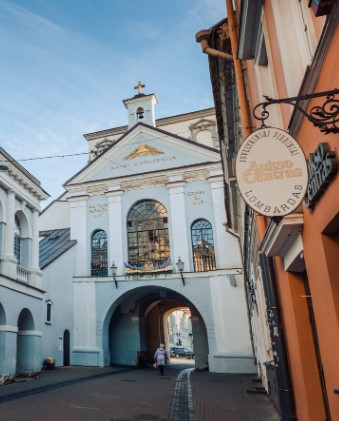
The Gate of Dawn, or Sharp Gate is a city gate that was built between 1503 and 1522 as a part of defensive fortifications for the city.
City gates often contained religious artifacts intended to guard the city from attacks and to bless travelers. The Chapel in the Gate of Dawn contains an icon of The Blessed Virgin Mary, Mother of Mercy, said to have miraculous powers.
Upon arrival we went hunting (online) about places to eat in the general vicinity of where we were. This is a common search for us on arrival in a town. The magic search phrases are restaurant near me, cheap eats near me, local food near me. We were surprised to find that the results trickled in rather than overwhelmed us.
Not finding anything that rang our bells, we decided to just wander about and see what we could see. What we found was an abundance of places to eat, but they were pop-up restaurants for the summer season. Not permanent fixtures but rather just places that took over open spaces and became an alfresco dining heaven.
The food was good, the prices were reasonable (maybe even cheap) and the setting was stunning. Warm (mid 20’s) summer evenings, cool beverages and great food offerings. This gave us some flashbacks of Spain and the way we lived back then.
To sum it all up, Lithuania was fantastic. We did not spend enough time here and will definitely put it on a list of places to come back to. August really is a spectacular time of year to visit here.
We made it to Inner Mongolia the first time around, but the logistics of getting to Mongolia proper were just too hard to manage back then.
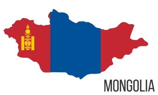
Mongolia is a basically an oval shaped country (2,400 km E-W and 780 N-S) wedged between China and Russia. Three quarters of the place is open pasture (The Steppe) which supports the huge herds of grazing animals for which the country is known. Mongolia is considered the world’s least densely populated nation, with 3.3 million people spread over 1.5 million square kilometres.
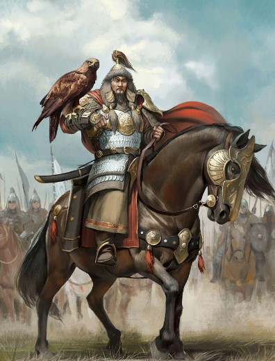
While many countries are denying or denouncing their imperial past, Mongolia is bucking this trend vehemently. They have proudly and brazenly embraced it. So much so that everything is about the great Mongol empire and their most famous of leaders.
Genghis Khan (1162-1227) known locally as Chinggis Khan, was a warrior-ruler and one of the most famous conquerors of history. He first consolidated the disparate tribes into a unified Mongolia and then expanded the empire through to the Adriatic Sea.
The empire lasted almost 400 years after his death. Mongolians see him as a symbol of their country’s strength and resilience.
The Mongolian nation was officially proclaimed in 1924, with the capital set around the main monastery of the Bogd Gegeen (spiritual leader) and was renamed Ulaanbaatar (“Red Hero”). While technically ‘independent’, for the first 70 years it was actually a one-party state closely tied to Russia (the Soviet Union). It received all technical, economic, and military assistance from Russia and generally followed Russian guidance in all matters political and economic, while building a socialist society.
After the collapse of the USSR, Mongolia ended the monopoly and embraced free multiparty elections, coalition governments, a new constitution, and installed greater cultural and religious freedoms.
Our entry saw us flying in to the Chinggis Khan International Airport (virtually everything here is/was named after Chinggis). This saw the first actual panic occur in the time since we have been away (600 days ago). Having no local currency Jill hit the ATM (as usual) but mid-transaction she was hit by the blue screen of death as the machine shut down and rebooted itself (with our card inside). Needless to say, some internal panic ensued over the next few minutes. But our card eventually spat out and we used a different machine, got our money and started the usual SIM card and taxi negotiations.
The airport is about 50 km out of town and provides you with an excellent opportunity to get a true sense of what you are getting yourself into. Flying in there is a single bitumen road (three lanes wide in each direction) and everything else is a dirt road or a paddock. Driving on the bitumen road, you pass gers (the local Yurt version), herds of cows, horses, goats and some truly stunning scenery.
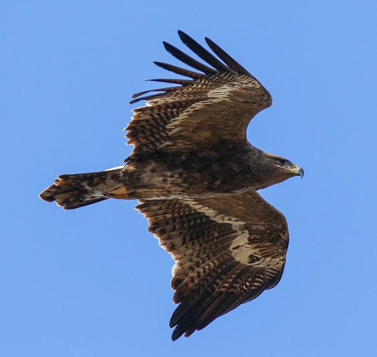
The cab ride in was astounding with some of the most amazing landscapes, sculptures and wildlife. Our first glimpse of a steppe eagle in full flight was just stunning. These huge muscular birds are quite the sight and can be easily spotted just glancing out the windows.
After a while the dirt roads on the sides give way to the city, enter the appearance of some amazing (and sometimes a bizarre) statues along the roads. The first thing that catches your eye is the abundance of Prius vehicles. Quite literally every second vehicle on the road is a Prius.
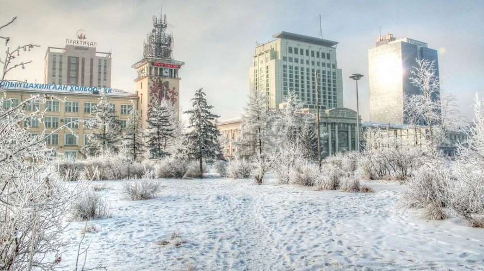
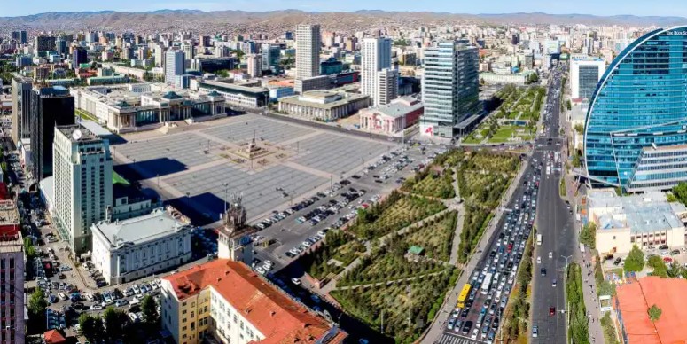
Ulaanbaatar is home to half of Mongolia’s three million population and is the coldest capital city in the world with heavy snow and cold lasting for three months.
As we were here in early summer, we missed all of this cold weather, and enjoyed some cool evenings and pleasant days in the mid-20’s. The cold is due to:
its high elevation (1350m),
relatively high latitude,
being hundreds of kilometres from any coast,
the effects of the Siberian high.
These factors combine to deliver winter temperatures of -40 degrees Celsius. With a temp range from -40 in winter to plus 35 in summer, Mongolia has an extreme and inhospitable climate where only the hardiest survive. Forty percent of the population still live as nomadic herders.
Ulaanbaatar (or just UB for us well travelled types) is surrounded by 4 sacred mountains (Bayanzurkh, Bogd Khan, Songinokhairkhan and Chilgeltei). South of UB, Bogd Khan Mountain is proclaimed as sacred and was declared a protected area in 1783, which made it the oldest national park in the world.
Our accommodation was at a boutique hotel, quite literally in the middle of everything. We were directly opposite the national museum, a block from the Chinggis Khan museum, right next door to the Parliament building and Sukhbaatar Square. This meant that our step count would not be high, but we were sure to see everything (around town at least). Bit worried about the gas mask in the cupboard though.
Almost immediately opposite our hotel was the National Museum, which would also be our first port of call. It was a great collection of all things Mongolian with a particular emphasis on the national dress over the years. Given that the Chinggis Khan museum was only a block away, that bit was a bit light on. But I was interested to find out that Mongolia had its own astronaut (Jügderdemidiin Gürragchaa) who went into space in 1981 as part of the Russian space program.
Being a Tuesday, the Chinggis Khan museum was shut so it was off to Sukhbaatar Square.
In the early 1800s, when UB was still in its infancy, a large square was constructed as the city’s center with the name “Great Freedom” (Ikh Choloo). After the People’s Revolution of 1921, the area was called “Indrin Square” and in 1946 was renamed “Damdin Sukhbaatar Square” to honor the Mongolian independence hero. It was renamed to Genghis Khan Square in 2013 and changed back in 2016.
The square houses statues of Genghis Khan, Sükhbaatar, and Sanjaasürengiin Zorig (who helped lead the democratic revolution of 1990).
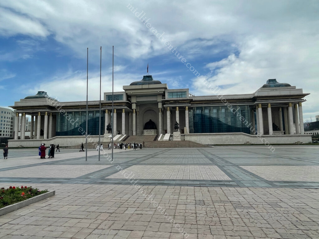
At the top (north) of the square is the Mongolian Parliament Building and the square is surrounded by some great soviet era old buildings that include, the stock exchange, the cultural centre (Соёлын Төв Өргөө), state opera and ballet and the usual big (local) banks.
National Parliament of Mongolia is the home of all government related stuff. The front of the palace has statues of Genghis Khan, Ögedei Khan, and Kublai Khan.
The statue of Genghis Khan is guarded by two of his generals Muqali and Bo’orchu on horseback.
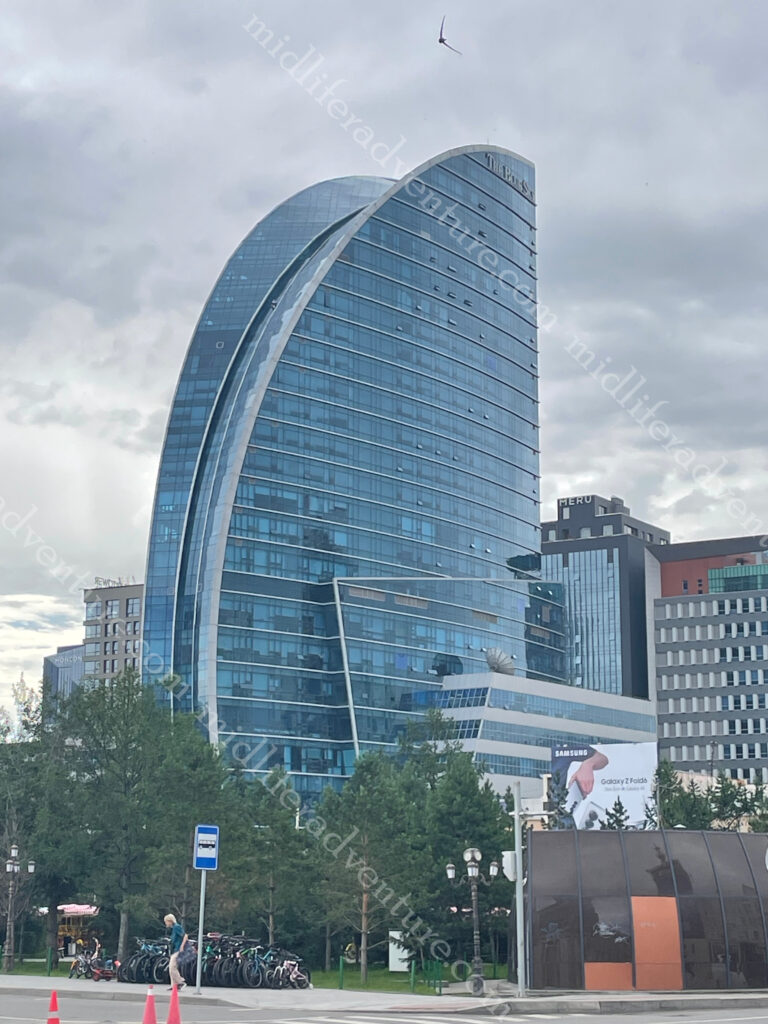
At the southern end of the Sukhbaatar Square you find the bizarrely out of place Blue Sky Tower (Хөх тэнгэр цамхаг). This is an ultra-modern 25 story, 105 meter, steel and glass skyscraper that houses luxury apartments, a 200-room hotel, restaurants, and office and conference space. To say it stands out is an understatement.
The second day it was off to the Chinggis Khan Museum. As you can imagine, this one had much more about the development of the empire and the tools of war, as opposed to the traditional costumes from the day before. Until recently there was no photos allowed but now for about $20 you can purchase an authorising lanyard and take some happy snaps.
Next stop for us was down to the State department store. Back in the soviet days this was the only (official) place to get your items. It was written up as an attraction in its own right. For us it was a six storey shopping hell. It was basically a Westfield, with all of the usual stores, selling pretty much what every shopping mall sells. The fur section was a little bit special and I did spend some time looking at a fur stoal made from a white arctic fox with head intact.
Our next day was meant to be off to the Palace (officially the Winter Palace of the Bogd Khan) but it was about a 2.5 km walk and the weather (rain) set in fairly nastily. Add to this the bride not feeling 100% in the preceding days, we decided to hide and boycott until the next day. Built between 1893 and 1903, the palace is where Mongolia’s eighth Living Buddha, and last king, Jebtzun Damba Hutagt VIII (often called the Bogd Khan), lived for 20 years.
To say that the palace has seen better days in underselling the situation. Extreme temperature fluctuations (-40 to +35) has seriously taken its toll on the older buildings. Despite this the Palace houses some important items (such as the Mongolian Declaration of Independence from China in 1911) as well as some gifts received from foreign dignitaries. Some of these include: a pair of golden boots from a Russian tsar, a robe made from 80 foxes and a ger lined with the skins of 150 leopards. The Bogd Khan had a thing for unusual wildlife and there is an impressive display of stuffed animals in the palace. At one point the Bogd purchased an elephant from Russia for 22,000 roubles.
Hidden in behind the Blue Sky tower you can find the Choijin Lama Temple Museum. This is a complex of five temples with elaborate paintings, colorful masks, and ornate statues. The monastery was built between 1904 and 1908 for the Choijin Lama, a brother of the Bogd Khaan who became Mongolia’s first leader after independence.
Most of the top things to do in UB are actually outside the city. So the next day it was in a car and out of town on a day trip in and around the natural beauty that is Mongolia. A hundred Aussie bucks bought us a car and driver for the day with an itinerary to boot.
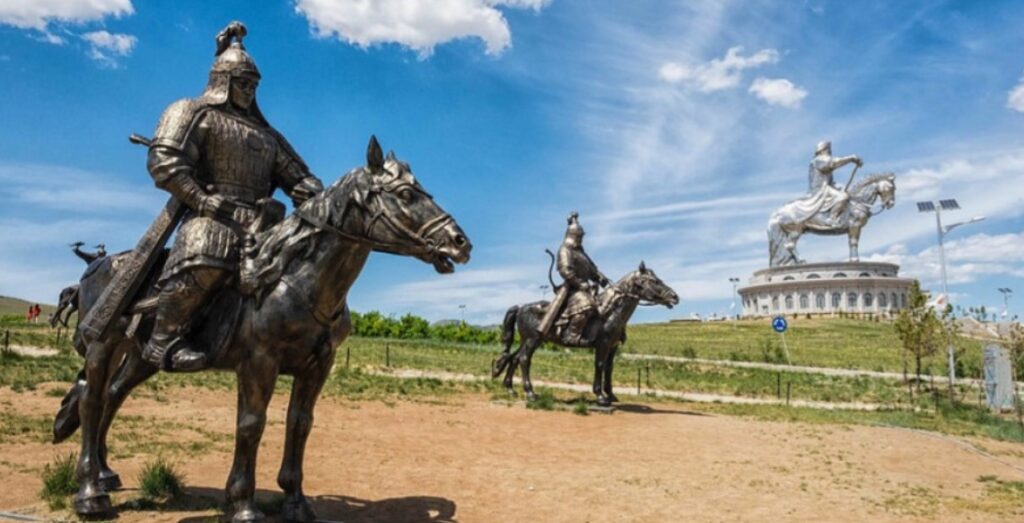
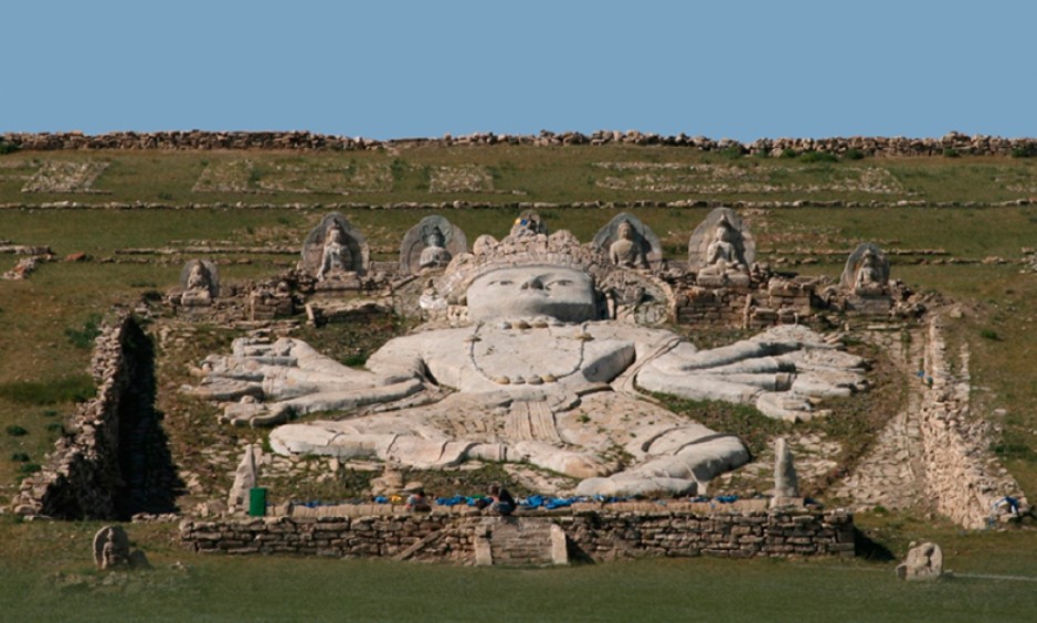
The most famous of thing to see is the Genghis Khan Statue Complex, about 54 kilometers outside UB. At its heart stands a 40 meter tall statue of guess who, perched atop a 10 meter pedestal.
The complex stands on the bank of the Tuul River and was built to commemorate the 800th anniversary of Genghis Khan’s birth. It is the world’s largest equestrian statue. The base consists of 36 supporting columns, representing 36 great Khans (Mongol kings) with the entrance gate to the complex being decorated with statues of the nine generals (noyons) of Genghis Khan.
To say that you can see this thing from afar is a tad obvious. Construction took three years, cost $4 million and used 250 tons of stainless steel. It opened in 2008, and the interior houses an art gallery, museum, a dress up shop, and the obvious souvenir and coffee shops, etc.
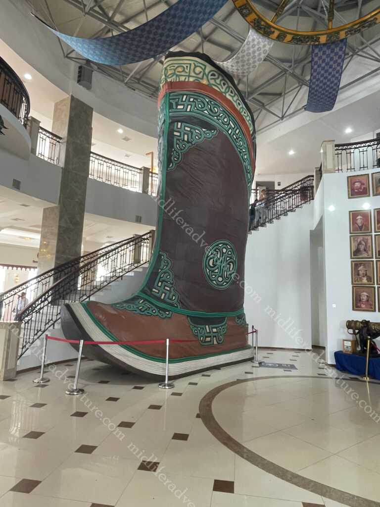
Most importantly, it houses the world’s largest boot (maybe). I say maybe because google doesn’t list it as such. This one is 9 meters tall and the one listed on the internet (in the USA) is only 16 foot (about half the size) tall.
There is probably some weird rule as to why this doesn’t count, but I don’t know.
Apparently, the current version of the complex is just phase one. Over time it is planned to place a whole town of the yurts to make up a thematic town, revealing all sides of Mongolian life. The complex was built here (Tsonjin Boldog) because according to legend, Genghis Khan found a whip in this area. In Mongolia, people believe that man finding a whip is a sign of fortune, good destiny, and occasion. The statue faces east, the direction of Genghis Khan’s birthplace.
After the statue it was off to the Terelj National Park. This is one of the most accessible national parks in the country, being about 70 km northeast of UB. It is known for its picturesque alpine scenery, interesting rock formations, and outdoor activities.
In short, we spent hours driving through some of the most amazing scenery that you can come across. We stopped at some obvious spots (like turtle rock) for photo opportunities, but in reality almost every second presented photo opportunities (the single lane road just wasn’t designed for stopping).
A small portion of the National Park has been developed for tourists, with hotels and tourist ger camps set up. These obviously come with the associated restaurants and souvenir shops. In addition there is a bunch of locals set up to take bus loads of (predominately) Koreans on horseback rides, hiking, rock climbing, swimming, rafting, and bird-watching trips.
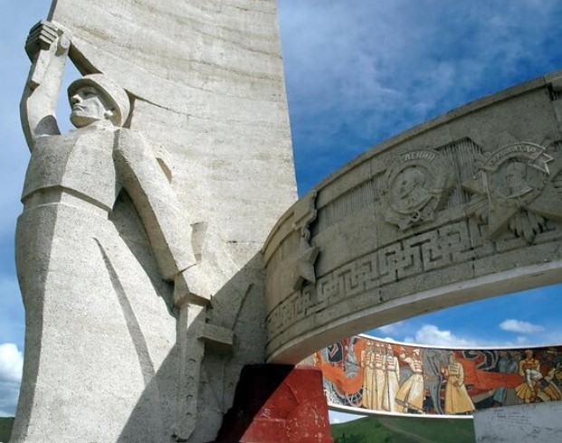
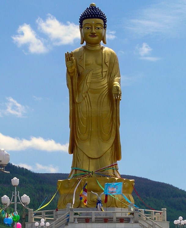
Our next stop was to be the Zaisan Memorial which was built on a hill to just south of town to commemorate those Mongol and Soviet soldiers killed in World War II. Sadly the mountain it stands on was shut to shore up some landslide activity – so we missed out.
While we missed out on climbing the mountain, at the point we got turned around, we had a perfect view of the big buddha.
Built in 2006 the Buddha statue looks through the entire UB city and protects the city from any danger.
Speaking of missing out, Eastern Mongolia has the Ikh Burkhant complex which has a 90 meter high stone Buddha built into the hillside. It was built between 1859-1864.
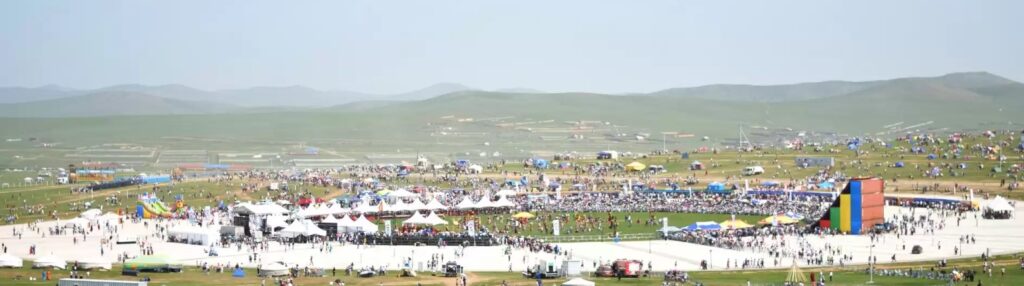
Naadam Festival
Sadly we missed this one by a couple of weeks (we were at Brads birthday when it was on), but this is the main festival of the nation. It is the most important holiday and biggest event on the Mongolian Calendar. The Naadam Festival includes the “Three manly games”. These are sports competitions of Wrestling, Horse racing and Archery. Despite the name, women participate in the archery and horse-racing games, but not in Mongolian wrestling.
The main festival is held in the capital UB, however smaller versions are replicated though the provinces and villages (soums). It begins with an elaborate Opening Ceremony featuring dancers, athletes, horse riders, and musicians.
Mongolian Wrestling (bökh), has no time or weight limits, and bouts end when one of the opponents hits the ground. Bökh wrestlers’ costume consists of 2 parts: upper part is called zodog and the lower part is called shuudag. The zodog & shuudag are usually bright red or blue. Wrestlers complete their looks with Mongol hat & Mongol boots.
Mongolian horse racing as featured in Naadam is a cross-country event, with races 15-30 km long. The riders are children (girls and boys), with the oldest being 10 years old and the youngest only 4. The racing routes are straight requiring less navigation and more speed and endurance.
Traditionally, children rode without saddles but modern consideration for the jockeys’ safety has introduced regulations requiring saddles, stirrups, helmets, vests, knee and elbow pads. In addition to this each rider must be covered by accident insurance.
Mongolian Archery involves 360 targets that are put up for the archery competition. In this competition, both men and women participate; men fire 40 arrows from 75 meters away while women fire 20 arrows from 60 meters away. The winners of the contest are granted the titles of “National marksman” and “National markswoman”.
Mongolian traditional homes – “the Ger or Yurt” are important part of Mongolian national identity. But, in rapidly growing UB’s life, you can see the ger districts on the fringes.
Mongolian Statues
Almost everywhere you look as you wander about town you end up running into some pretty interesting statues. Some are of the famous Khans etc, but many others are just there. they can be found at almost every intersection. Some you have to hunt for while others jump out at you. My favourite was the Predator riding an Alien motorcycle, or the whole caravan of camels in the middle of a roundabout.
Taxis
While wandering the city we did learn the trick of the local cab system though. Basically, every car is potentially a taxi, just wander along with your arm dangling out a bit and somebody will stop. I suggest you are more organised than I was, as my pronunciation left much to be desired. Maybe take a screenshot of where you want to go and just show the driver, knowing the distance in advance makes the price calculation and end of trip communication much easier. The fee is 2000 tugrik (about a 90c) per kilometer and I just rounded up the parts of a kilometer based on the google map distance.
The Black Market
Our last full day saw us venture to Naran Tuul or the Black Market (using the above taxi method). As sketchy as a Black Market sounds, nowadays it is all pretty legit. There are warnings of pickpockets and bag snatchers and scammers trying to elicit an entrance fee to the free market, but none of these eventuated for us.
What really strikes you about UB’s Black Market is how much and what there is for sale. This is a market aimed at the locals and seeing what is on sale makes you realise how different Mongolia is to the rest of the world. The size of the material section was huge. Rows after rows of material and sewing gear. Clearly many of the clothes remain home made.
For me most of the interest lay in the boots. Mongolian boots are truly a thing of beauty, not just the pointy toed traditional types (gutuls), or the warm felt Ugg boot type things, but just the normal everyday boot. They are magnificently made, of the softest leather, and are really nicely styled.
This is the big drawback of this sort of travel, our souvenirs and trinkets must be small and light. Otherwise the likelihood of me leaving with some fantastic boots was high.
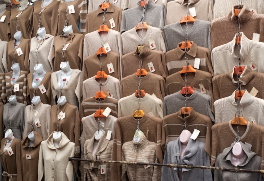
Mongolian Cashmere
Mongolian cashmere is widely considered to be the best in the world. The harsh climate makes it an ideal environment for cashmere goats to grow thick undercoats.
Cashmere is a type of wool obtained from the soft undercoat of the cashmere goat. The wool is harvested during the spring molting season when the goats naturally shed their undercoat. Mongolia is the largest producer of cashmere, accounting for more than 50% of the global production., with India, China, Iran, Afghanistan, and Kazakhstan producing the majority of the rest.
And here you can find it almost everywhere you look. Like everything else in Mongolia, it is mot cheap, but the quality is exceptional.
Mongolian Food
Food in Mongolia is certainly a melting pot. Today, you can get just about anything you want and the quality is pretty good. If you look at the surrounding nations and those that at one time made up the empire, it is pretty normal to think that the variety would be wide.
There are plenty of local restaurants offering (some) traditional dishes that are worth the effort in tracking down. And some other traditional dishes that maybe only for the more adventurous (more about that below). Veggies in summer were tough to find and I assume that this is worse in winter. Many of the local dishes are high in meat content (but there’s nothing wrong with that).
Chinese is everywhere, as is burgers and pizza, Turkish, Italian, Indian, Korean and Japanese. Then the surprising ones come into play Mexican was the one that threw me most. But we had Uzbek, saw Azerbaijani, Kyrgyz, Irish pubs, Vietnamese, Spanish tapas and a surprising number of vegan and vegetarian restaurants (we didn’t go there).
Local Dishes
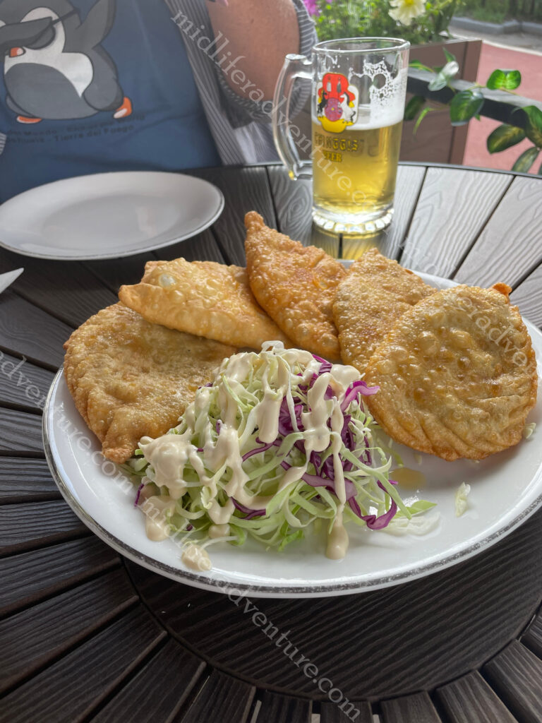
Khuushuur or Huushuur – A local version of a deep fried meat pie that more resembles a pasty or an empanada. The filling is just meat and onion.
It was the first thing that we ate on night one as a beer snack (they looked small and bite sized) but they came out the size of your hand and we ended up not needing dinner.
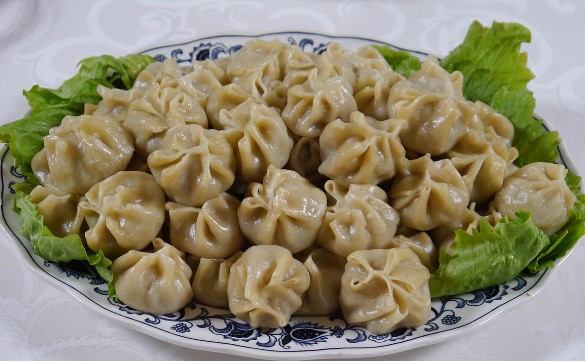
Buuz is the Mongolian version of the steamed dumpling commonly found throughout the region. It is basically a local version of the Chinese baozi or the Nepalese Momo.
Bansh is like the buuz but smaller and boiled in a soupy kind of broth rather than steamed. The filling usually comes from either a cow, goat, sheep, horse, or camel.
Tsuivan is a local stir fry made with home made fresh noodles with vegetables and a meat of some kind. Not the most thrilling meal about, but hearty and filling.
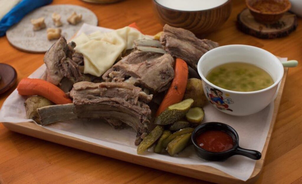
Chanasan makh is next and it is basically just boiled meat. Not really too much to say about this one, it is what it claims to be.
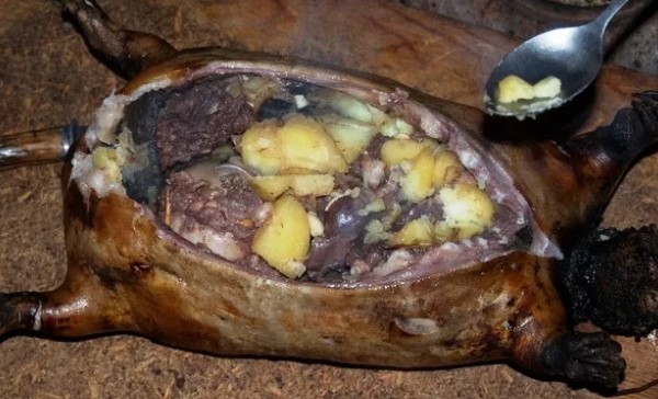
Khorkhog is a goat stew that uses the entire goat and is cooked on open fire with hot rocks. The quirk here is the belief that holding the hot stones after cooking helps to relieve tiredness and improve blood circulation.
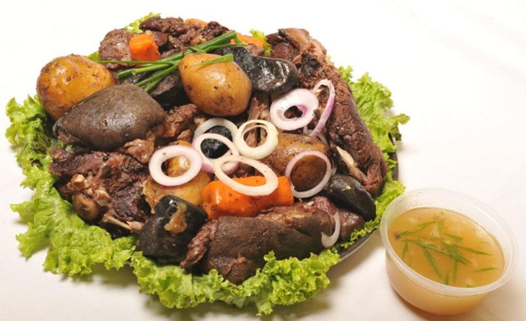
Boodog involves using the actual skin and fur of the animal as the cooking vessel. The animal is butchered with skin remaining intact and is sealed up having been filled with the meat, vegetables, and hot rocks to cook from the inside out.
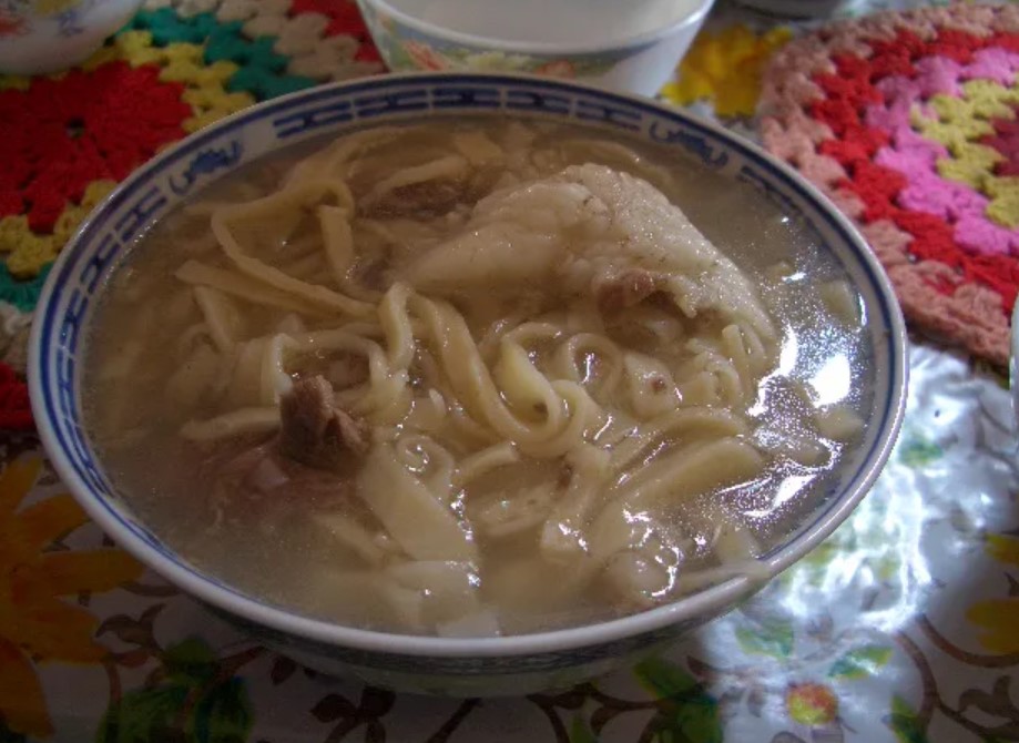
Guriltai Shul is one of the most popular noodle soups in Mongolia. It is considered to be the classic dinner staple – basically just boiled mutton with handmade wheat-flour noodles.
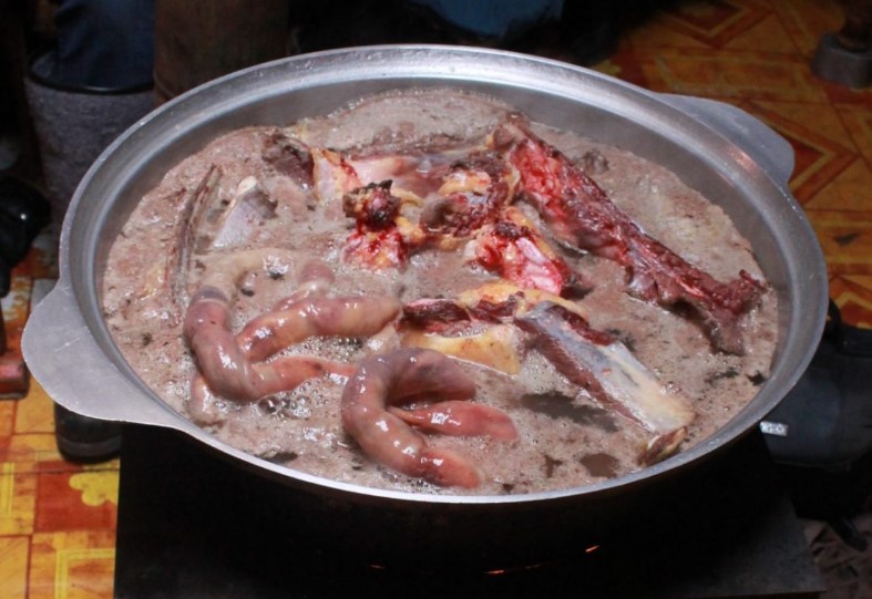
Vitals soup is popular for being very nutritious. It is part of Mongolia’s culture that no part of an animal is wasted and so Vitals Soup is offal. Made with the lungs, hearts, intestines, liver, stomach and kidneys of an animal.
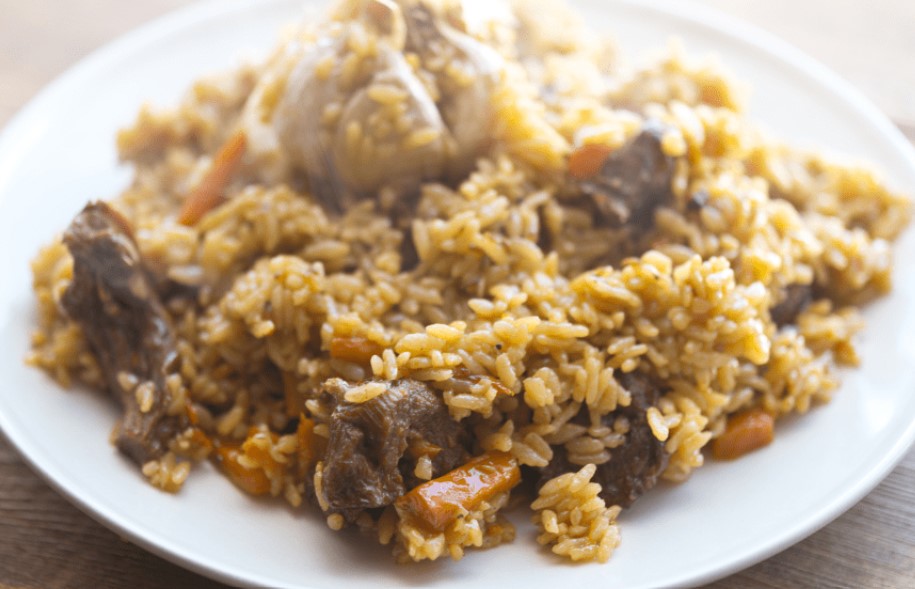
Needless to say that neither Jill nor I rushed to order the Vitals soup. Budaatai huurga is a nice simple (inoffensive) local fried rice version with mutton.
Last and definitely least is Airag, or Kumis this is considered to be the country’s national beverage. It is fermented mare’s milk. We had it in inner Mongolia a decade ago and it was terrible. The memory was strong enough for us to both avoid it at all costs.
Mongolian Beer
This was a tough one. Having once had such a mighty empire, the beer was highly variable. Some of the best beers that we have had were in Kyrgyzstan who had adopted the best of Czech brewing practices to deliver some really tasty beers, and you could find some really tasty ones here. But at the same time the empire stretched east, which brought into play the lighter Chinese style brews. These were much more gassy and less flavoursome.
Possibly the hardest part of the beers was working out what you were actually drinking. Niislel (Нийслэл), Sengur (Сэнгүр), Borgio (Боргио), Golden Gobi (Алтан Говь), Jalam Khar (Жалам Xар) and finally the only one I could get my tongue around, the Chinggis Pilsner.
Japan has long been on my list, and has been recommended to me by virtually everyone who has ever been here.
The issue that has kept us away for so long was the perception that it was prohibitively expensive. The Japanese pricing just did not fit with our cheap and cheerful travelling style.
Japan is made up of over 6,800 islands but with four main ones being Hokkaido, Honshu (the “mainland”), Shikoku, and Kyushu. Tokyo is the capital and largest city, followed by Yokohama, Osaka, Nagoya, Sapporo, Fukuoka, Kobe, and Kyoto. About 75% of its area is mountainous.
The most fascinating thing about Japan is the obscure blend of ancient traditions and cutting-edge modernity. Rich and often ancient cultural heritage combines with groundbreaking technology all set in a land of amazing landscapes and wildlife.
The decision to come happened on two fronts, the first was convenience, our journey to Mongolia was easiest with a transit through Japan and secondly, the exchange rate with the AUD was the highest it had been in over two decades.
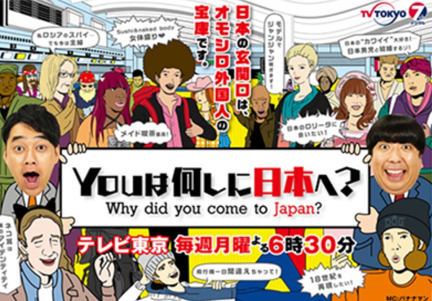
Our arrival saw us entering Tokyo, Japan’s bustling capital in mid evening, only to be jumped upon by a TV film crew, who wanted to interview us for a local travel TV show. It was a fluff show about where have you travelled to, why did you come to Japan and what did you want to see. The answer to the first question blew them away and we spent the next 30 minutes answering questions about our travels so far. Jill’s hat (with all of the pins on it) drew amazement and the thought that two people would just pack up and disappear seemed totally impossible to the Japanese mindset.
We have no idea if we were selected to be on TV (as we had left by the time it would have aired) but it was to be on Monday evening at 6:30 pm on Channel 7 TV Tokyo.
After this, we very quickly learned that our language skills were heavily lacking. Some serious bumbling about in the train station and we were on our way headed for the hotel. Some weather prompted a train change and some more confusion, but for the most part, getting about was fairly manageable. We finally landed in the hotel after 11pm having left metro Manila 14 hours earlier.
The next morning it was up for a quick breakfast and out exploring. The first thing that strikes you about Japan is how clean everything is. The footpaths are at least 4 meters wide and can be up to 10 meters wide in the busy areas. There is not a rubbish bin in sight but there is zero trash, anywhere. It was even a struggle to find a leaf laying on the ground. And there is no obvious person sweeping up or cleaning anything, people are just tidy and don’t make mess..
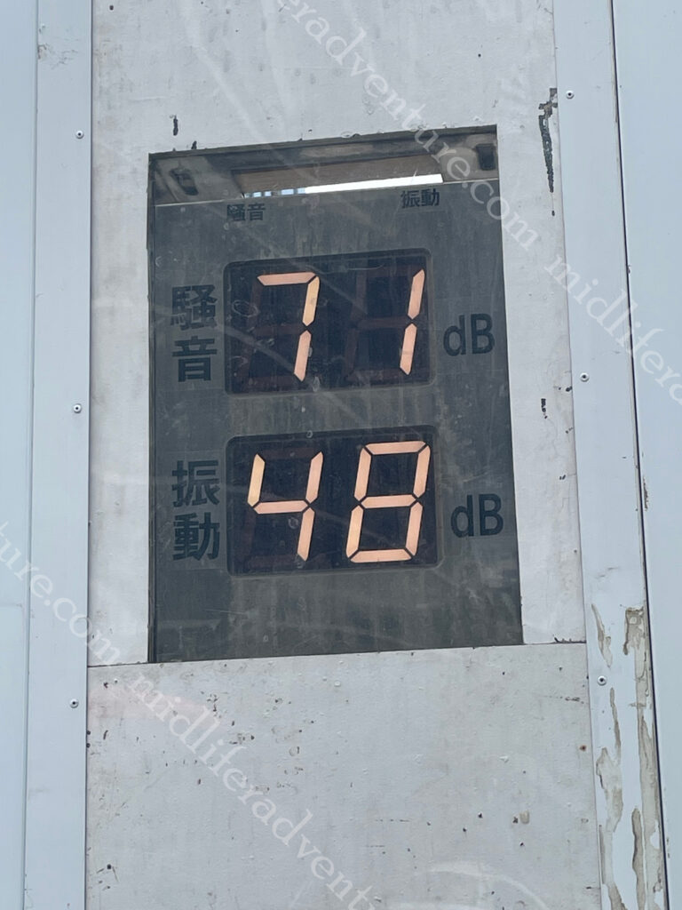
Not only is it clean, it is quiet. Having spent the last 2 months in the Philippines and Indonesia, this place is absolutely silent. No honking, beeping, screaming, yelling.
It was lovely.
It was so quiet that there were even decibel meters on the outside of constructions sites to make sure that things stayed at a reasonable level.
Our walk around was on a 30+ degree day with high humidity. Our first stop was to the NihombashiBridge that has been linking the city for centuries. The first wooden bridge was completed in 1603 and the current one dates from 1911. In reality the bridge is dwarfed by everything around it, but it is nice.
Next we aimed for the Imperial Palace, but to get there we went via the Tokyo Central railway station. Within no time of getting to the train station we immediately felt that we were in the world’s most populous city with over 37 million people inhabitants. And the majority of them were here.
To say that this place is a maze is an understatement. There is quite literally an entire underground city here. There are kilometers of underground tunnels and passageways that link the high speed rail (shinkansen) to the subway and you can even walk to the nearest five stations completely underground (the furthest a distance of over 2 km), but is faster by train. There are more than 4,000 trains arriving and departing daily.
Having been lost underground for what seemed like an eternity, we popped out relatively close to the Tokyo Imperial Palace and Gardens Area. Here we learned an important lesson. In the most populace city in the world, if you want to do something, you must book, days in advance, and you must queue up for your allotted time slot.
We did not do this, so were content enough to view the palace and gardens from the outside and did not venture in. But suffice to say that the surrounds were also pretty amazing.
Being a cool 33+ degrees with high humidity we chose to walk. From the palace we walked through parks and gardens, stopping at the various shrines and temples that we came across on the way.
From here our exploration took us into the Ginza District which is considered to be one of the most expensive, elegant, and luxurious city districts in the world. It is a popular upscale shopping area (something that we typically try to avoid). Our aim was to go to an interactive digital art museum that offers galleries of immersive and surreal installations (but guess what, you had to book, days in advance). So we wandered around lost for a while, found a place with an (happy hour) amazing lunch which set us back $26 for four beers and a feed. We did however make the booking for 4 days later.
The next morning it was up and on our way to see the lively hub of Shibuya. This is arguably the youth heart and soul of the city. For us it is the home of the scramble crossing, the busiest pedestrian crossings in the world, with sometimes over a thousand people crossing the multi-cornered intersection at a time. The view from the Shibuya Sky observation deck offers an epic view.
When we were there, extensive roadworks had stifled the flow of both traffic and pedestrians. But the tourist trade and normal business activity still meant that the place was manic, god knows what it would be like in full flight.
Japanese Street Fashion – To say that Shibuya is eclectic would be an understatement. The streets of Shibuya are the birthplace to many of Japan’s fashion and entertainment trends.
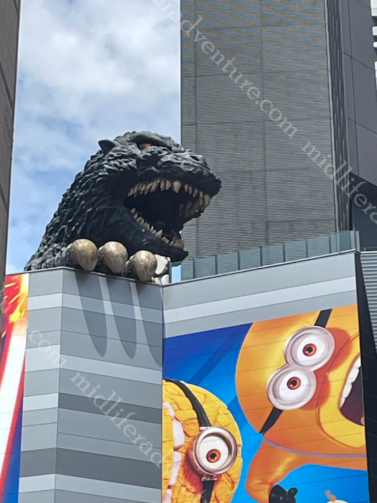
Just down the road we headed into Shinjuku to see the Godzilla, towering over the Toho Cinema. It is probably the most famous statue in all of Tokyo but on closer inspection, it is just a head and claw.
The area is busy and lively and I was offered sex at 11am by some random dude who wanted to take me to the nearby brothel. I just had to follow him down the alley.
Next it was on a train to the old part of town (Yanaka) where the old town ambience and atmosphere (shitamachi) reminds people of Tokyo from past decades. It was a funky little neighbourhood without the lights and bling of those we had visited before. The main attraction was the Yanaka Cemetery where many of the tombs are elaborately decorated and nicely landscaped. Paths are well-kept and wide, making it a good place for a tranquil stroll (even in extreme temperatures).
From here we hopped on the local bus and made our way to the Asakusa neighbourhood. Our main reason for going there was to see the Samurai and Ninja Museum, but guess what, you had to book. Thankfully the wait was not too long so we went exploring first.
The first thing that we stumbled across was the Asahi Beer Tower and Asahi Super Dry Hall with its characteristic Flamme d’Or. This was completed in 1989 and is the headquarters of Asahi Breweries.
With some time to kill we kicked back in the backstreets, checking out some funky little shops and restaurants, and even a Kabuki theatre.
Asakusa’s main attraction is Sensoji, a very popular Buddhist temple, built in the 7th century. Having snuck in around the back (it is free to enter we just came the back way) through the side streets we came out from what is usually the main entrance Nakamise. This is a shopping street that has been providing temple visitors with traditional snacks and souvenirs for centuries.
Having seen the masses of people, the temple and bought out our souvenir trinkets we headed back to the Samurai and Ninja Museum which turned out to be a great way to kill an hour or so. Some interesting history, and lots of swords and armour. You can even throw ninja stars against walls and dress up for photos if you want (we passed on the dressing up). The coolest bit was that there was some seriously good artwork on the walls.
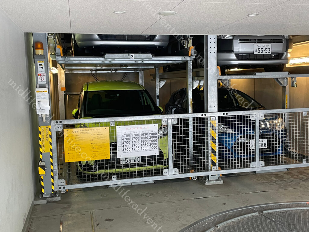
Space being a premium here in Japan, even the parking structures were a bit different to what we were used to. I had heard of the stacking system, but had not seen it in action before.
Jill being a raw fish fanatic had been humouring me in the preceding days giving me actual cooked meals, but the time had come for her to get her sashimi fill. We found a restaurant around the corner that allowed here to load up on raw fish and all was right (for her) in the world.
Japan is highly regulated (socially) and it is easy to inadvertently do the wrong thing. But a little bit of preemptive reading and the sort of things that will cause offence are actually pretty sensible and easy to avoid, if you only bother to look. Things not to do in Japan:
be late
be loud
talk on the phone on the train
tip at restaurants
stand on the right side of the escalator
wear shoes on tatami (woven straw) mats
These are actually really really easy to avoid, and for the most part, make life a little more pleasant. Virtually everyone that we came across followed these rules easily. Except the Americans and the French. Whether these two groups are just above such petty conventions or are just too arrogant to care, I do not know. But the only voices that could be heard splitting the silences were always one or other of these two accents, consistently.
The next day was the closest thing to a fail as we have had in years. Don’t get me wrong, we had a lovely day, but apart a fleeting glance (of Mount Fuji) from a train window we did not achieve our goals. We had seen photos like the ones below and thought what a great way to spend a day, so we hopped on the fast train (it is 140km away) to see it.
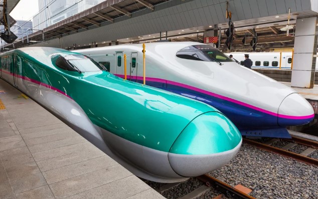
Japan’s Shinkansen, or bullet trains were our transport. They are world class with some reaching speeds exceeding 321 kilometers (200 miles) per hour. The newest versions have reached speeds of up to 603 km/h (374 mph) in testing.
While in transit, Jill did snap this photo (and a few like it) out of the train window.
So we did see the mountain, just not in the way that we had planned.
Getting off the train we hopped on a slower train that (we thought) would take us closer to the mountain and more specifically Lake Kawaguchi.
Lake Kawaguchi is located at the northern foot of sacred Mt. Fuji, Japan’s highest mountain. This is one of the Five Lakes of Fuji and you can enjoy magnificent Mt. Fuji views from the lakeside. But we got on the train to Odawara and then another to Hakone (still 60kms away from the mountain). To be fair there are about six locations in Hakone where you can enjoy good views of mount Fuji (but we did not go to any of them).
Instead, we got on the Hakone Tozan Cable Car thinking that it would give us the views that we sought. This is one of Japan’s few mountain railways where passengers can enjoy scenery and be wowed as the train climbs steep slopes. In order to climb the mountain, the train zigzags up the slopes using switchbacks where the conductor and driver switch positions. The cable car connects Gora and Sounzan and meets up with the ropeway to Owakudani (which was of course shut due to the winds). So we got near the top of the mountain with the views (on the opposite side) and could go no further.
So a long story short, we left our hotel at 7 am and got back late in the afternoon, in that time we had traveled on fast trains, slow trains, cable cars and saw some amazing sights of rural Japan. But what we actually came to see we got in fleeting glimpses as we went passed it on a super fast train.
As we waited to head home, I did manage to get a few videos of the superfast trains going past.
To say that these are fast and impressive is obvious. These ones even slowed down as they were passing the station.
We did have a great day, and we did see some amazing sights, we just did not really achieve what we had set out to do.
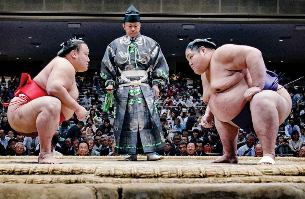
Sumo is a thing that we missed out on while we were here. It is a Japanese style of wrestling and Japan’s national sport with grand sumo tournaments (each lasting 15 days) held six times a year (the odd months).
While we were in Tokyo, there was a tournament on 350 km away in Nagoya. When there is no tournament you are able to head to one of the Sumo Stables to watch the early morning practice sessions. But these are suspended when a tournament is on (so we missed out).
As big as Sumo wrestlers are (many over 200 kg and the heaviest ever maxing out at 288kgs), doctors reckon that they don’t suffer from heart attacks, strokes, or display other symptoms of obesity. Sumo wrestlers consume up to 7,000 calories a day. The secret is in the name, as wrestlers the regular intense exercise prevents the build-up of visceral fat, which causes metabolic and heart disease.
Manga is the Japanese term that refers to both comics and cartooning. The origin is believed to date back to the 12th and 13th century.
After WWII the manga were distributed widely to the population as a distraction from the harsh realities that Japanese people had to face after the war.
They are characterised a distinctive art and narrative style. Genres include action, romance, fantasy, science fiction, and more.
Anime is a Japanese style of film and television animation.
The style is distinctively Japanese and immediately recognisable.
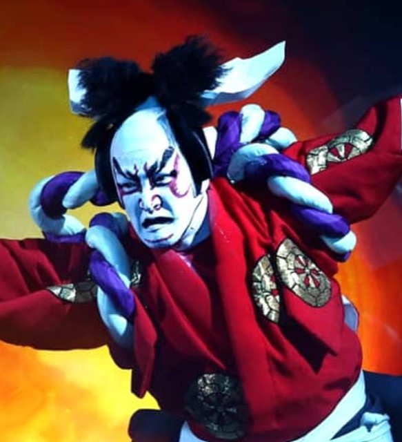
Kabuki is a form of Japanese theatre that mixes dramatic performance with traditional dance.
It is known for its outlandish performances, glamorous costumes, and the elaborate makeup.
Not wanting to miss out, our reservation for the interactive digital art museum finally came up on our last evening in Japan.
The creators describe itself as an international art collective existing at the intersection of art, science, technology, and the natural world.
The group consists of a variety of artists, programmers, engineers, animators, mathematicians and architects; the collective aims to explore the relationship between the self and the world, through new forms of perception.
In reality it was a really high tech maze in darkened rooms with images and lights projected on the walls.
This is actually an over simplification, the lights sensed the presence of a person and bent around you, the exhibitions flew from room to room and around corners.
And colours changed, kids drawings were brought to life and flew across the walls, it was all pretty surreal.
To be honest we have seen almost nothing of Japan. Everything that we did see, we enjoyed but it is a seriously weird place. It is like nowhere we have ever been. Both relaxing and infuriating at the same time. I got totally sick of being lost in underground bunkers, railway stations and shopping malls. We were constantly staring at the GPS trying to work out where we were in an underground land of no reference points.
The exchange rate doubling made it actually really affordable for us, so if things remain favourable, I could envisage us coming back at some point. The food was magnificent.
Our lead-in to coming here was filled with expectation as the research on this city seemed to promise so much. We were coming off a long period on the ship so were looking forward to being on land and eating dodgy street food again. So much so that we factored a whole week into staying here exploring the olden and current wonders that it had to offer. Even if it meant having to schlepp our bags again.
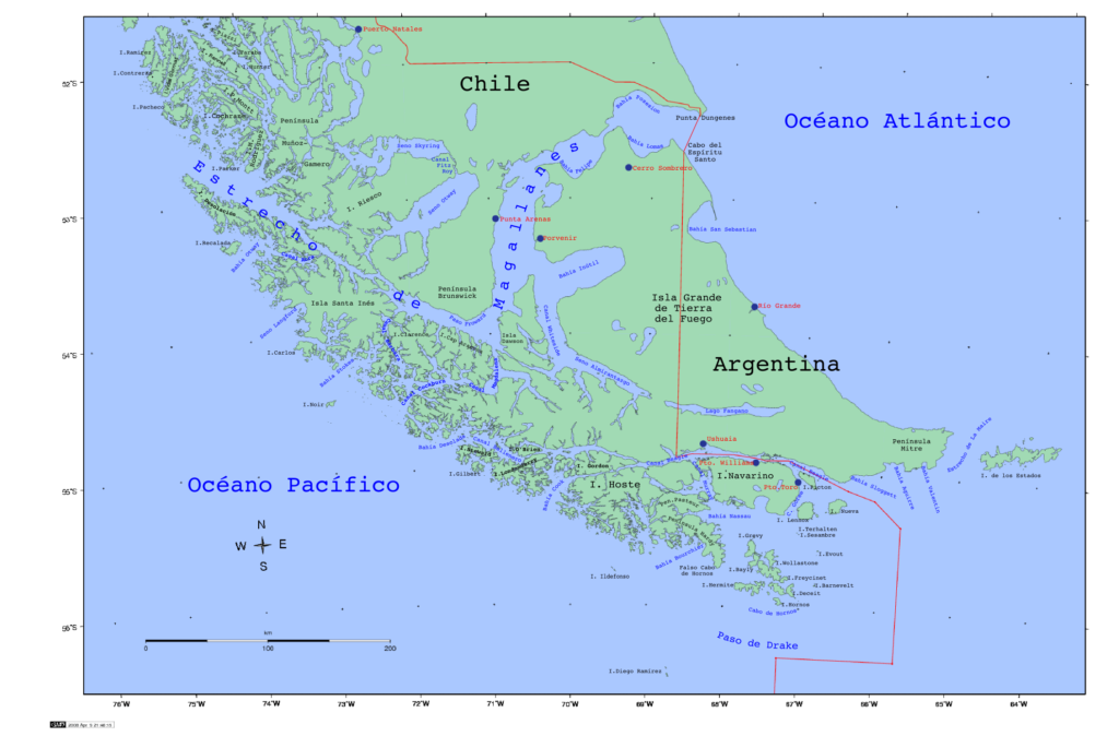
Lets set this up a bit, Valparaiso sits on the Pacific coast of Chile and was considered one of the most important port towns in the world, up until the building of the Panama Canal. In its heyday, the city provided respite to thousands of sailors heading from Europe to California.
Prior to the Panama Canal, ships from Europe would travel south down the coast and cut through the Strait of Magellan (to avoid rounding Cape Horn) in order to get to the Pacific Ocean.
During the gold rush it was a major trade route and became known as “the jewel of South America”. It is the home of Latin America’s oldest stock exchange, the continent’s first volunteer fire department, Chile’s first public library, and the oldest Spanish language newspaper in continuous publication in the world (El Mercurio de Valparaíso). In 2003, the historic quarter of Valparaíso was declared a UNESCO World Heritage Site.
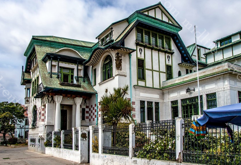
Because of all of this trade in the 18th 19th and the 20th centuries some amazing colonial and post colonial-style buildings were built, along with palaces and estates of wealthy businessmen.
Well, Valparaiso was a bit of a disappointment. Since the building of the Panama Canal, the place has pretty much gone to pot. The stunning old buildings are now just crumbling down, are boarded up or are in just a disgraceful state of disrepair and neglect. What promised so much yielded a city in neglect.
Rioting and protests (over inequity) took place between 2019-2022 after economic assessments identified that 1% of the population in Chile controls 26.5% of the country’s wealth, while half of the population have only 2.1%. The trigger to the conflict and protests was the raising of metro fares. But this 3 years of unrest have left virtually every surface of the city scarred or vandalised.
But the recent rioting belies the decades of neglect that preceded it. To say that Valparaiso is poor is an understatement. Makeshift street markets are everywhere with people trying to sell the most inane low-value items just to make a buck. Used clothes and shoes, toiletries, and even used phone chargers lay on blankets on the streets while someone tries to turn over some cash from them. It is like a permanent car boot sale on every street (without the car boot).
Plazuela Anibal Pinto is the practical if not official heart of town. It features the statue of Neptune that was built in 1892. From the plaza as you look up the hill you will see a bright yellow house perched on the top of a cliff.
This house is on the corner of a barrio (neighbourhood) known as Concepción. The Concepcion neighbourhood is the home of all art in Valparaiso. Everywhere you look is street art of varying kinds. Some are mere graffiti that gets reinvented almost daily while others are exceptional murals by well-known artists. This area is the key to revitalising and reinvigorating the town.
We took a funicular up the steep hill to the Concepcion Barrio to check out some of the amazing street art. We wandered the streets and took our happy snaps and dodged the tour groups as they similarly checked out the artworks.
As great as this neighbourhood (Barrio) was, and as much potential as it held for revitalising the city there was still work to be done. From high on the hill, surrounded by artworks, there was only about 2-3 places to sit and have coffees, cakes and lunch. There was not a bar in sight and restaurants were almost invisible. An entrepreneurial spirit could set this place alight.
And then of course the whole thing was ruined by a recent trend of mugging tourists. The short-sightedness of people astounds me more and more often every day.
Funiculars
Between 1883 and 1916, around 30 funiculars (bizarrely, sources seem unsure of the exact number) were constructed to connect the businesses of the Lower Town with the residential districts on the hills above. Many of these still survive and are officially listed as National Monuments, although not all of them are currently in service.
These Funiculars save some serious leg work for the princely sum of about 50c. As we were at the bottom of the plaza, we took the Ascensor Concepcion, one of the first funiculars built in Valparaíso.
Palacio Baburizza is the former residence of Croatian businessman Pascual Baburizza located in Valparaíso, Chile. It was built in 1916 by Italian architects, and eventually turned into a museum in 1971, and declared a historic monument in 1976.
The Plaza Sotomayor is the original customs square and is lined by the old buildings of the city that fill the full blocks of the surrounding streets. But mostly it is dominated by the palatial blue-coloured Edificio Armada de Chile (headquarters of the navy). The focus of the square is a monument that honours the Chilean sailors who fell during two battles that took place in 1879.
At the northeastern side of the square are two similar towers, which create a sort of gate entrance to the port from the city.
The statues were nice, or they would have been if they were not all covered in spray paint and pigeon shit. The parks were nice, even if mostly used as urinals and beds for the homeless. It is not that this place was terrible because it wasn’t. It was just the disappointment of how far it had fallen from where it once was and where it could be.
Despite the poverty and threats of muggings, at no point did we feel unsafe. The town was nice, if a little dishevelled and mostly friendly. The prices were pretty comparable with what you would pay for things in Australia, but the quality of what you would get was lesser.
I guess the thing for us was that our accommodation was substandard. We were paying a high price for a place that had no interest in having guests. It was a hostel, but in reality it was more of a rest home for lazy millennials. They had carved themselves a beautiful niche for themselves where they listened to music with noise cancelling headphones and ate free food and did nothing. They had multiple wifi options but only theirs worked. The ones for the paying guests would not even connect.
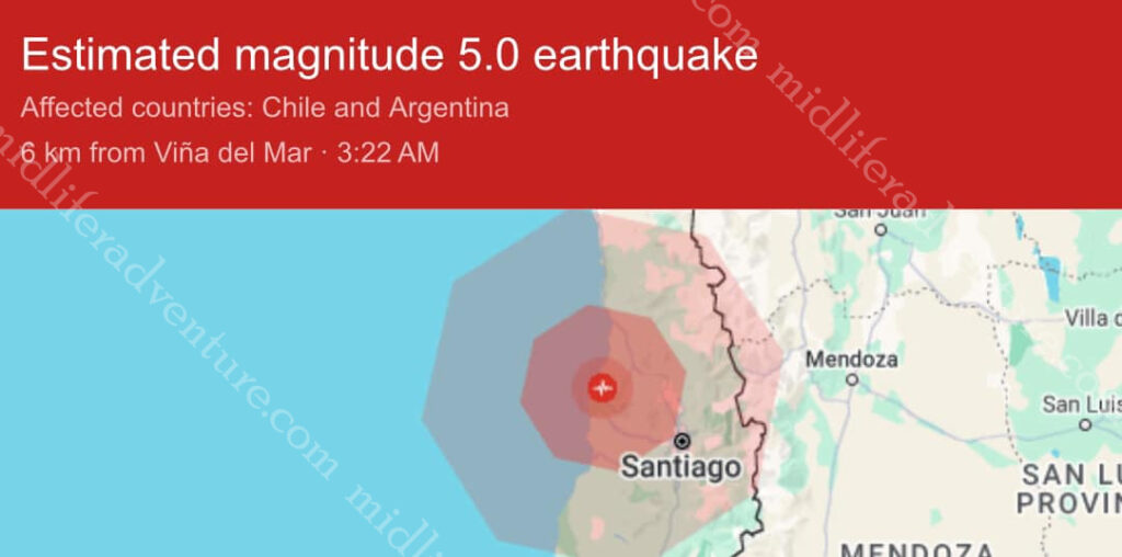
The list of what was wrong was too long to get into but suffice to say the place was terrible. So after a couple of days when we were woken at 3am by a massive thump that was enough. As it turns out, we had just experienced our first earthquake. The town was set against an ocean and on the side of a mountain. Neither places you really want to be in the case of a major earthquake.
A mere 5km from where we were was the epicentre of a 5.0 magnitude earthquake. So we got up at 3am, packed our bags and dressed for a rapid departure (in the fear of aftershocks etc).
The rest of the evening/morning was drama-free but with all else going on in Valparaiso, we took this as a good enough sign that it was time to move on. So we found our way downtown and hopped on a bus and went to the capital of Santiago.
Valparaiso could have been an amazing experience, and can again be one. I am certain if our accommodation was not so shitty we might have been less inclined to dash away. A quick investment in some urban renewal and a curbing of petty street crime and this place could once again be fantastic.
A few public toilet blocks, some paint given to those seeking jobs and this place could be very different. They are already trying. There has been an addition of market stalls along Avenida Argentina where the open-air food market takes place every Wednesday or Saturday. If this was open to the other marketeers in between times the place would be tidied up and given an aura of legitimacy rather than the current version.
It would be interesting to come back in 3-5 years to see if progress is made. It is now on the cruise ship ports of call so there is regular trade starting. A clever plan, well executed could see this place getting back towards its former glory.
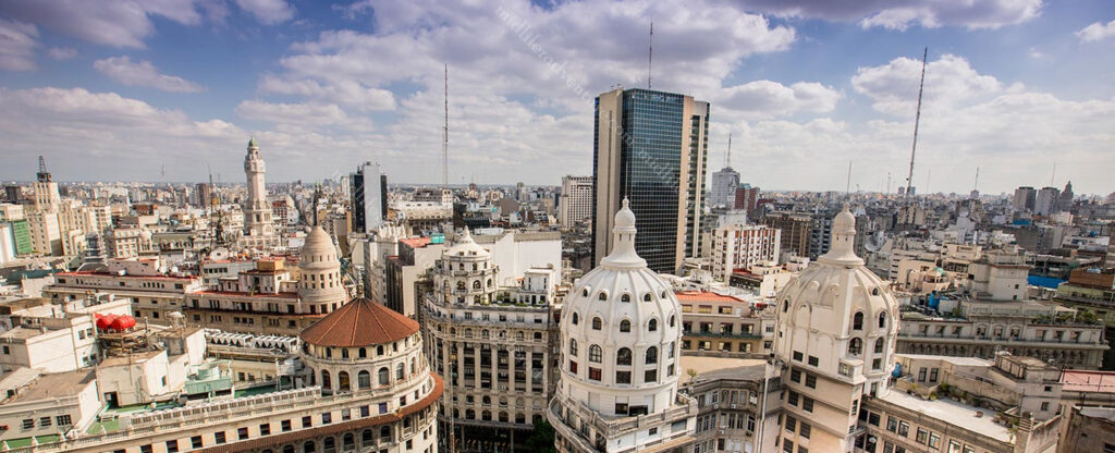
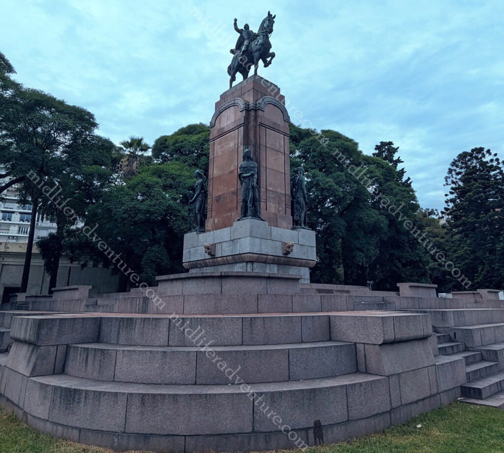
Buenos Aires is the capital and main city of Argentina. The city is located on the western shore of the Río de la Plata, on the southeastern coast. “Buenos Aires” is Spanish for “fair winds” or “good airs”.
According to the blurb it was the Spanish coloniser Pedro de Mendoza (in 1580) that established the first settlement there, which he named Nuestra Señora Santa María del Buen Aire (“Our Lady St. Mary of the Good Air”). Buenos Aires locals are referred to as porteños (“people of the port”) because so many of the city’s inhabitants historically arrived by boat from Europe.
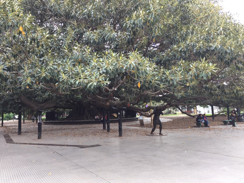
Our arrival into Buenos Aires was similar to those, and we came in through the port. We were just one of several ships in that day, and to say that the port was bedlam, would be an understatement. We had teamed up with our dinner buddies (Kurtis and Mark) who had a thing for gardening, so we got out of the port and Ubered our way to the botanical gardens (for about $4).
I am much more a statue guy than a garden guy, and the photos clearly reflect that. That said, the gardens were nice, with the exception of the mosquitos that absolutely loved by high quality Aussie blood. There were trees aplenty and even a butterfly garden buried among all of the foliage.
To say that Buenos Aires is a dog friendly city would be an understatement. The sheer number of dogs in public parks and on leashes wandering the city was astounding. And these pooches are seriously pampered.
Sadly the wealth and influence of the city far overshadows the rest of the country. But as with all cities Buenos Aires also reflects Argentina’s economic and social problems. Homelessness and drug use were evident, although at no point did we feel unsafe or uneasy.
After the gardens we found a few little holes in the wall that fed and watered us for a ridiculously cheap price. Jill and I had 3 empanadas each washed down by a pint of the local brew (and a sampling of some others – including an on tap gin and tonic) for the princely sum of $8.40. After that we found a local deli and then a bakery, damn I think I might be falling in love with Argentina.
One of the major attractions of the city is the Recoleta Cemetery. In 1822, the former garden was turned into the first public cemetery in Buenos Aires. Known as the “city of the dead” or “city of angels”, Recoleta cemetery has a layout similar to a city with one main street, diagonals, narrow corridors and internal passageways.
It is set in an area of 5.5 ha (14 acres) and you will find around 4800 vaults and mausoleums. The cemetery is more of an open air museum than anything else. As soon as you walk through the doorway you are met with amazing architecture, works of art and sculptures.
More than 20 presidents, 25 city mayors, 40 governors, Nobel prizes, writers, politicians, engineers and even a caretaker are buried at Recoleta cemetery. But the most famous is that Recoleta Cemetery is the resting place for María Eva Duarte de Perón (known as “Evita”).
Outside the cemetery is a park known as Intendente Torcuato de Alvear. This area turned into a huge market on day two of our exploring.
Plazoleta Chabuca Granda (the oldest tree in town) also sits in the square outside the cemetery. It even has a statue of a dude holding up one of the super heavy branches.
Just next door to the cemetery you can find the Nuestra Señora de Pilar church. Built in 1732 it is one of the oldest in the city.
In reality I got a bit turned around when exploring here. On day one we were at the cemetery and on day two we were at the Nuestra Señora de Pilar church (to follow). In reality these are side by side but I entered and exited the cemetery from the same way and did not even realise this. The next day we came at it from the opposite side and took a photo of the church that I had almost sat on the steps of the day before.
Buenos Aires is an amazing city with wide avenues and a true cosmopolitan flair that feels more European than Latin American. There are some huge colonial landmark buildings but the real feel of the city is the differences between the individual neighbourhoods. Each one has its own distinct feel and have their own meeting places, generally coffeehouses or bars.
At night Buenos Aires’s nightclubs (boites) come alive as people flock together to dance the tango.
This famous dance originated in the lower-class areas of the city and is said to ‘reflect the soul of the Argentina’.
While we didn’t go to a tango club, the ship did bring some of the best dancers on board that evening to put on a show.
If you want to do the full tourist thing there are any number of these boites that will offer you dinner and a tango show.
But in reality, if you wander about a bit at night, you almost cant help but run across random tango breakouts.
As we were in town for two full days and day one was taken up with gardens and the cemetery, day two saw us hitting the major sights and the neighbourhoods. Lets say up front, two days was not enough. But it was what we had, so we hopped a cab ($5) to Plaza de Mayo which is the oldest public square in Buenos Aires.
The square is named after the Argentine revolution, which began on 25 May 1810. It has been the scene of many of the most important events in the city’s history, from the second founding of the city in 1580, through the revolution of independence, to more recent political demonstrations.
Around the square are several important buildings: the Cabildo (old town hall now national museum), the Metropolitan Cathedral (where Pope Francis conducted mass for 20 years), the Casa Rosada (Pink House or Presidential Palace and site where Evita gave some of the more famous speeches), the national revenue office, the national bank and the intelligence secretariat.
As a random bit of knowledge, apparently, they used to do a version of running of the bulls in the square, prior to the revolution.
The Pirámide de Mayo is at the hub of the Plaza de Mayo and is the oldest national monument in the city.
It’s construction was ordered in 1811 to celebrate the first anniversary of the May Revolution.
It was renovated in 1856 and in 1912 was moved 63 metres with the idea that a much larger monument would eventually be constructed around it.
Having done the plaza we walked past the bank and along one of the many parks to explore the city more fully. We wandered along wide avenues and took in the interesting mix between the old and new parts of the city.
La Boca is a colourful neighborhood of Buenos Aires that is characterised by the street artists, narrow streets and brightly painted buildings. In the middle of La Boca is Caminito, a narrow alley flanked by zinc shacks that reflect the district’s early immigrant days. Caminito is more of a street museum than a traditional alley and the area gathered significance as the inspiration for the music for the tango “Caminito (1926)”.
Asado is the term used for South American barbecue. This type of meal is common in Argentina, Chile, Paraguay, Peru and Uruguay and usually consists of beef, pork, chicken, chorizo, and morcilla (blood sausage). These are cooked on an open fire or grill (called a parrilla) and usually eaten with side dishes and red wine.
Buenos Aires is the city with the highest number of football stadiums in the world. The city has at least 18 professional teams, and the passion for the sport is visible on almost every street corner.
The passion of Argentine football fans is legendary creating an electric atmosphere at each game. The fans choreograph chants, design tifos (giant displays), and ignite the stadium with their undying passion. When doing some research I found the following “Argentine football stadiums are not just structures made of bricks and cement. They are temples of passion, history, and culture. Each corner echoes with tales of legendary matches, iconic goals, and unforgettable moments. Every seat has witnessed emotions ranging from the ecstasy of victory to the heartbreak of defeat.”
How can you really argue with that.
Our last part of the day involved a run down the hill from the cemetery past the Recoletta, through the park (and the market), past the statue in honour of Carlos María de Alvear a military revolutionary (and the towns first mayor).
Across the bridge, through the park, past the bizarre statues of kangaroos and to the massive law school building. I tried to get the story behind why there were kangaroo statues in Buenos Aires but had absolutely no luck.
We didn’t get here but in the Parque Tres de Febrero you can find the 1960s-built planetarium. Looking like a UFO it has projection room with a 20 meter dome and reclining seats for viewing projections of the stars.
And our final port of call before heading out of town was to the Floralis Genérica. This is a sculpture made of steel and aluminum located in Plaza de las Naciones Unidas (United Nations Plaza) that was donated to the city by the Argentine artist.
Buenos Aires was amazing. It was neat, clean, friendly and extremely cheap. Meals, taxis and ubers were all incredibly cheap and we have already decided that we will be coming back here many more times.
Oman (officially the Sultanate of Oman) sits at the mouth of the Persian Gulf. It shares land borders with Saudi Arabia and the UAE (west) and Yemen (southwest), while sharing maritime borders with Iran and Pakistan.
It has a population of a bit under 5.5 million.
The Rub’ al Khali or the Empty Quarter is the desert portion of Oman but also encompasses parts of the UAE, Yemen and Saudi Arabia. It is 1,000 kilometres long, and 500 kilometres wide and has sand dunes with heights of up to 250 metres
Our early research had us a little more excited about Oman as at first glance there seemed to be plenty to see and do. We were a little terrified coming into it as our Aussie dollar exchange rate came in at 25 cents. This meant that one of their real was worth $4 for us. Jill put us right in the heart of tourist land.
Our hotel room was not a shadow on our one from Abu Dhabi. It was the width of a bed and this was the door.
As I am a touch taller than Jill, I sconned myself on this door (and others around the hotel) on several occasions.
One of these has given me a gash to the head, concussion and likely brain damage.
The seaside area of Mutrah was to be our home for the next few days. Sadly the room paled in comparison with the luxury that we had in Abu Dhabi but the location was fantastic. Looking straight out of our window we had direct views of (and about a 300 m walk to) the Mutrah Fort.
At the bottom of our hill (250m), we were on the Mutrah Corniche. This is a 3km long promenade along the waterfront, which of course is lined with cafes, restaurants, and markets. You have views of the Oman Port and harbour (including the Sultans Yacht) and the Hajar Mountains with its Portuguese watchtowers on the other side.
Our first task was getting up at 6 am and walking along the Corniche to the fish market and dhow harbour before breakfast. Even the dodgy, smelly fish market was impressive. Stainless steel troughs. mosaic tiled walls and of course the freshest of fish that you could find.
As finding food in the Middle East had proven a touch challenging at times we have taken to getting breakfast included in our hotel. And so far, Oman is winning.
After our breakfast, we climbed the hill, paid our admission and hit the fort. Now this was a first. There was nobody there. We had the entire fort to ourselves for about 30 minutes. We roamed and explored and took our photographs with absolutely nobody else to contend with. When we were finished and were walking out the door, we passed the baton to two German guys who then also had it to themselves. Hitting the bottom though a group of about 10 arrived, so their solitude would have been short lived.
Having finished at the fort we hopped the local bus for a 4-5km ride to the National Museum of Oman.
Along the way you see a bizarre space ship looking thing on the right.
Apparently to celebrate the 20th National Day of Oman in 1990 this monumental incense burner was built on top of a prominent hill at Riyam Park.
Getting off the bus was a bit of a catch all as within a short walk of where the bus drops you off, you have the Museum, the Al Alam Palace (the official palace of the sultan), two Portuguese forts of Al Jalali and Al Mirani and some major government buildings.
But the Museum was first.
The palace was the next obvious place to head as it was only a few hundred meters away in a straight line. But it was also in full sun with no shade and no respite.
The next was the forts, which were basically each side of the palace. Unlike the Mutrah Fort, these were unable to be entered and climbed upon. But they were kind of big enough and obvious enough to get some nice photos.
At this point we had melted. While the actual temperature of Oman is lower than places like Saudi Arabi, the humidity raises the “feels like” factor considerably. While walking around at 1:30 in the afternoon we got our own personal record when we hit the “feels like” temperature of 52 degrees centigrade. We were cooked.
The last stop before running away to hide from the heat was the Muscat Gate Museum.
Having got our gate photos we grabbed drinks (melting) and were waiting the 5 minutes for the bus to arrive. At this point a taxi pulled up and beeped (a common thing-touting for business). But this guy already had a customer. He was already being paid and was going past the Souk (our get off point) and took us for free – just to save us waiting in the sun. Now that was a first.
So after hiding through the afternoon (after showers and attempts to wash the sweat from clothing) we waited for early evening and made our way down the hill to the Mutrah Souk. This is one of the oldest markets in Oman and was right on our doorstep. We had briefly wandered through during the afternoon but it is the evening when the Souk really takes off.
The next day, another amazing breakfast and on a bus back towards town to see the things we had passed on our way in. Stop number one, the Sultan Qaboos Grand Mosque. It was officially opened in 2001 and has become Oman’s most important spiritual site. It was closed on the Sunday that we tried to visit. While we did not get to enter the mosque we still had access to wander the grounds outside and get some happy snaps. The mosque was built to hold 20,000 worshippers and is home to the world’s biggest 1-piece handmade Iranian carpet and the second-largest chandelier in the world.
Directly opposite the grand mosque is the Omani Parliament building. It was built in 2013 and sits on more than 100,000 square metres. It has more than 5 km of facade and the centrepiece is a 64 m clock tower (the highest in Oman) with each of the clocks having a 4.8 metre diameter. The building is known locally as the Majlis Oman.
According to the blurb the Parliament building has been equipped with a range of well-paced spotlights, with modern LED technology and underground lighting fixtures. This means that at night the whole 38-metre high wall is illuminated with a controlled washing effect over almost all of the surface.
The Royal Opera House area which is an event in itself. The building is imposing and our first glimpse of it was in the taxi on the way in (mosque and parliament too), which prompted us to get back here a few days later. It isn’t just the opera house but more of an entire precinct for the arts and cultural pursuits. It is regularly used and has the capacity for 1,000-seat concert and opera theatre. But with 15,000+ square metres, over six levels with three basement floors, it can easily change its configuration to cater to most events.
So Oman is our favourite so far. It is authentic. It has actively resisted the current trend (looking at you UAE) of advancement at all costs and has maintained those things that make it special. There are tons of forts all over the country and deserts and oases worthy of exploring.
Abu Dhabi is both a city and an Emirate and is situated on an island in the Persian Gulf. The annual rainfall for the area is less than 2 inches. The majority of the city is on the island but most of the residents live in suburban districts on the mainland. The city is connected by bridges to the rest of the country.
The Al-Mafraq bridge is a multi-layer interchange bridge and it has 27 lanes which allow roughly 25,000 automobiles to move per hour.
The city was planned in the late 1960’s by a Japanese architect for an expected population of 40,000 (now around 1.5 million). Abu Dhabi has a 2030 plan that seeks to build numerous skyscrapers. It has a number already built and more under construction. There are also, many other skyscrapers over 150 m either proposed or already approved for construction.
Having hopped off the plane we were aiming for our hotel. To get there using a taxi would have been 170, the Uber was 130 and the bus was 8. So the bus it was and we got delivered about 250 meters from our hotel. Upon arrival, we found out that the room that we had booked was fully sold out. So they chose to upgrade us to a suite. And what a lovely suite it was too. No more grotty backpacking for us. We were on the 16th floor of a 19 story, hotel with multiple rooms, a laundry, a kitchenette and just generally an incredibly lovely place to be.
As we drove in on the bus we drove past possibly the most colossal building that we had ever seen. This was the Sheikh Zayed Grand Mosque. So the next morning it was back on the bus to check this out properly.
The mosque was started in 1996 and more than 3,000 workers and 38 contracting companies worked over the next decade to build the mosque. It was designed to last and the materials chosen in its construction reflect this. These materials include marble, stone, gold, semi-precious stones, crystals, and ceramics. Overall it covers over 2.2 hectares and can safely hold 41,000 people. It is the largest mosque in the UAE and the third largest in the world.
We have been to some pretty amazing places over the years and this one is right up there with the best of them. the manicured gardens coupled with the quality of workmanship, inlaid marble, gemstones the whole thing just reminded me of a modern day Taj Mahal, but bigger. Oh and based on the photos above, can you tell the difference between Jill’s phone and mine.
Qasr Al Wasan is the presidential palace of the United Arab Emirates. It was built in 2017 and opened to the public in 2019. It is primarily used for official purposes like hosting foreign leaders and for meetings of the country’s supreme council and federal cabinet.
Yas Island is a purely commercial enterprise here in Abu Dhabi aimed entirely at the tourism market. It is a 25 km2 island and one of the largest tourism projects in Abu Dhabi. It is most famous for the Marina Circuit that has held the Formula One Grand Prix since 2009.
But beyond the racing, the Island hosts numerous 5 star hotels, golf course, high end residential developments a huge water park and a Warner bros theme park. Entirely manufactured Yas Island was named the world’s leading tourism project in 2009.
Ferrari World is a mostly indoors theme park based on the famous car brand. It has the world’s fastest roller coaster (Formula Rossa) and the ability (if you meet the criteria) to do fast laps in a Ferrari.
Oh and obviously someone from Abu Dhabi had been to Las Vegas. The ground in certain areas of the city was littered with the business cards of the local hookers.
Something that I first saw in Las Vegas back in the 1990’s (and still occurs today).
Well Abu Dhabi has learned and embraced this too.
Abu Dhabi was ok. Our hotel was fantastic, and the things that we saw were good but most of the tourist things on offer (theme parks and shopping malls) were not really to our tastes. The architecture is amazing and everywhere you look when you are driving around you see fantastic buildings on monumental scales. The city has certainly come a long way from its fishing and pearl diving roots.
Travelling the world in a pre and post COVID state