The area that is now Finland was settled around 8,500 BC during the Stone Age towards the end of the last glacial period. The artefacts the first settlers left behind present characteristics that are shared with those found in Estonia, Russia, and Norway.
Finland covers an area of 338,145 square kilometres (130,559 sq mi)[4] and has a population of 5.6 million.
In 1906, Finland became the first European state to grant universal suffrage, and the first in the world to give all adult citizens the right to run for public office.
The nation remained a largely agricultural country until the 1950s. After World War II, it industrialised quickly and established an advanced economy. It became a member of the EU in 1995, the Eurozone in 1999, and NATO in 2023.
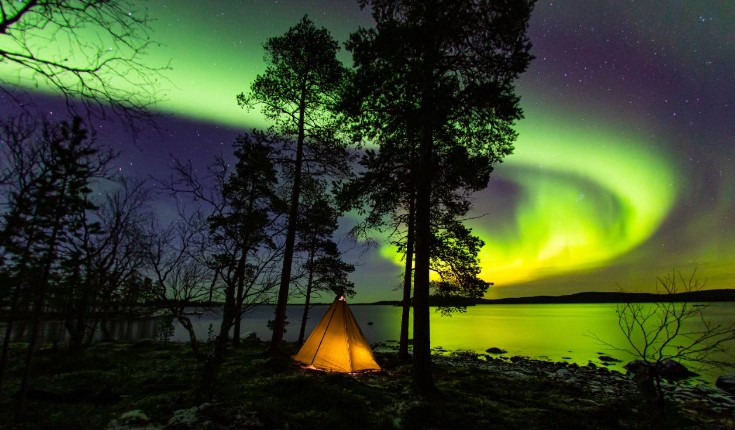
Finland in the summer months – the sun doesn’t set at all in the northernmost parts of the country, hence the nickname “The Land of the Midnight Sun.” In the winter, the opposite happens, and the sun disappears for months. This time is called “kaamos”.
And – if you’re lucky – the Autumn and Spring may bring the colourful Northern Lights (photo from visitfinland.com).
And according to the WHO (World Health Organisation) Finland has the best air quality in the world.
Getting here
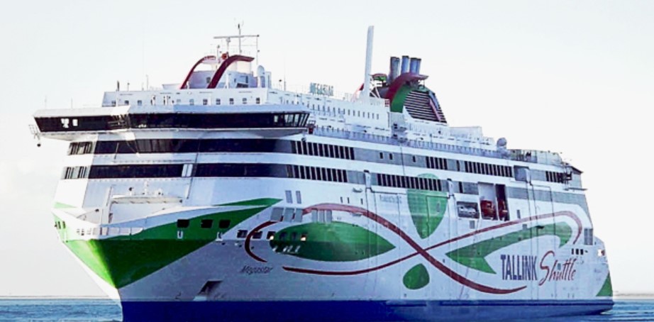
Our trip to Finland from Estonia was on the ferry. I must be honest and say that the idea of a ferry was not all that appealing. But on arrival I was met by more of a cruise ship than a ferry. The modern European ferries make the Australian ferry options look absolutely prehistoric. Our trip was on the Tallink Megastar.
The Megastar is the newest ship in the Tallink fleet and has been operating since 2017. The 212 metre vessel can hold 2800 passengers and reach speeds of 27 knots.
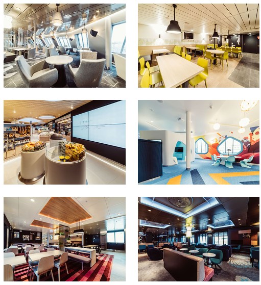
It has restaurants, bars, the largest mall on the Baltic Sea and a 2,800 square meter Superstore (think Myers) that is a fully stocked.
Add to this a huge duty free shop where you can get spirits, wines, beer, cigarettes, sweets, cosmetics and perfumes.
The garage area has a capacity of 150 vehicles.
The ride only took 2 hours and there was quite literally not a wave to be seen. The Baltic Sea (at least when we were there) was a millpond. Long story short, my fears of the ferry were unfounded and in reality this is the best and most relaxing way possible to get around up here.
Helsinki
Helsinki is the capital of Finland with a population a bit over 600 thousand. I will state right now that the beer and the local food was absolutely the lowlight of our time here in Finland. Both the price and the taste left us both unimpressed. We did find a Syrian restaurant that saved us, but the local fare on offer was not great.
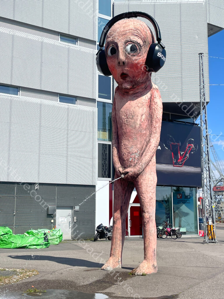
Our introduction to Helsinki was when we left the port and walked about a kilometer away to get our Bolt car without the harassment of the local cab drivers. Here is where we found the Bad Boy. It is a pink 8.5 metre sculpture made of concrete that weighs in at about seven and a half tons. And it is of a boy pissing. The water flow in the sculpture is heated so the boy can urinate all year round, even in winter.
It was was originally ordered as part of a public art festival in Sweden, where it urinated into a river in a park.
It then moved to Market Square in Helsinki where it urinated into the ocean in front of the Presidential Palace.
It most recently moved to in front of an electronics store, where it acquired a set of headphones.
There is a HOHO bus in Helsinki, but it is €34 each, and the town centre and loop really isn’t that big and is easily walkable. The Mannerheimintie is the central avenue that runs through the heart of the capital. Unlike the old towns of the Baltics, Helsinki is a very modern city.
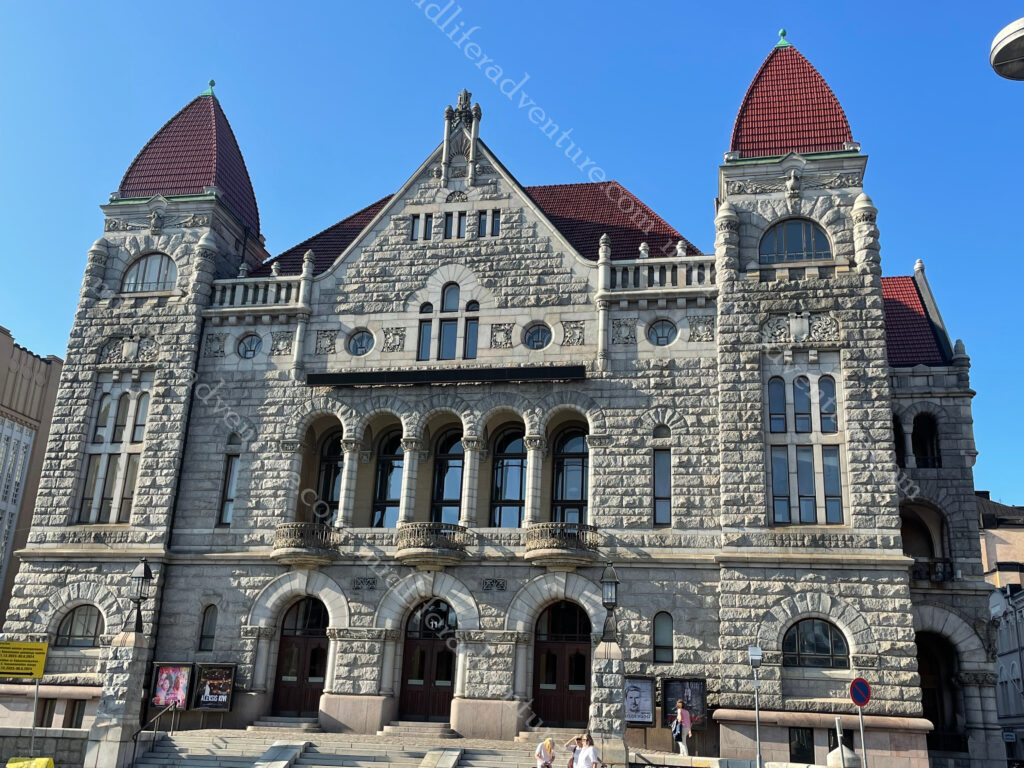
But we were here and it was time to explore. Our wander towards town saw us looking at some interesting looking buildings, nice parks on a cool and pleasant day in the heart of town. Once we got to the circular Swedish Theatre we were in the heart of it.
Modern blocks, full of rows of shops and shopping malls to rival any modern city on the planet. There was the odd glimpse towards something vaguely historical, but for the most part it was just a modern city. The central railway station signalled the start of a bit more character. The railway tracks were built in the 1860s an the granite clad station in 1919. The building is known for its clock tower and the Lyhdynkantajat (“The Lantern Bearers”).
Just down the road from the train station you come across Rautatientori square and the the Finnish National Theatre. founded in 1872, is the oldest Finnish-language professional theatre in the country.
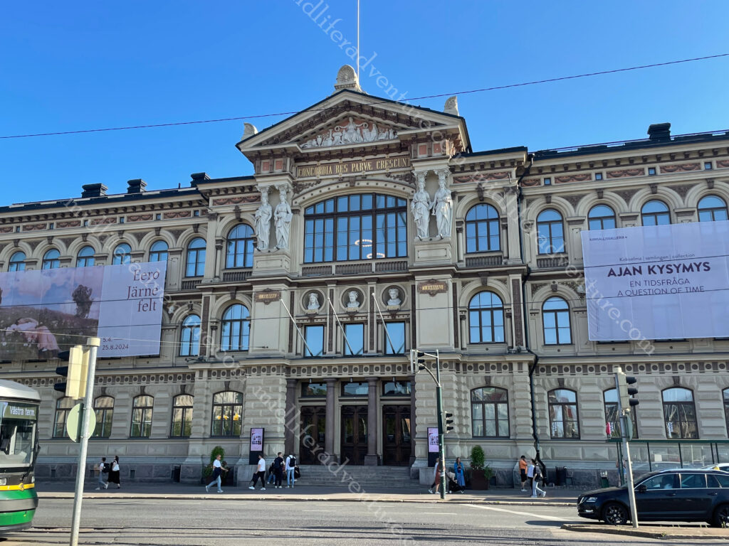
Across the road you find the Ateneum, which is the major Art museum in Helsinki. It is one of the three museums that forms the Finnish National Gallery.
The National Museum was closed for renovation at the time we were here. But when it is open it looks like this and it traces the Finnish history from the Stone Age to the present.
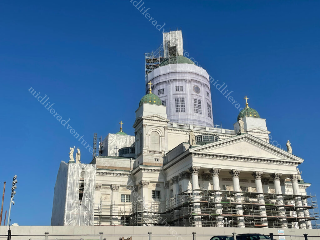
Helsinki Cathedral was one of the must do major attractions and once again, it was under construction.
The usually stunning building was covered in scaffolding.
While the main building was under renovation, they did leave one side free for photographs. Added to this the Cathedral sits on Senate Square, which is impressive enough in its own right. The square is in the oldest part of central Helsinki and is ringed by the Cathedral, the Government Palace, the main building of the University of Helsinki and the oldest building of central Helsinki (Sederholm House dating from 1757).
Having had enough for day one and walking plenty we made our way back towards our accommodation, stopping for some very poor local beers and bites on the way. The next morning a great breakfast primed us for another day of walking to explore the rest of the city. But first we headed down to the location of the open air flea market. This was clearly just a weekend thing, and after standing and scratching out heads for a while it was back to the Mannerheimintie.
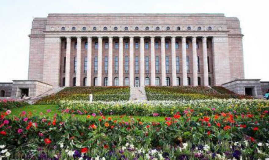
Also on Mannerheimintie you will find the Parliament house which was designed and built after WWI.
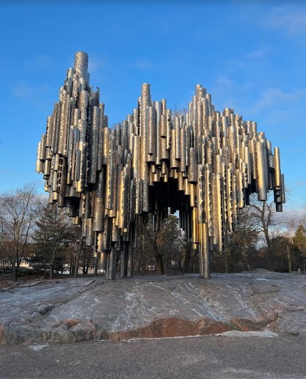
The Sibelius Monument is a park sculpture dedicated to the Finnish composer Jean Sibelius (1865–1957). It controversially looks like organ pipes, despite the composer not making music for the organ.
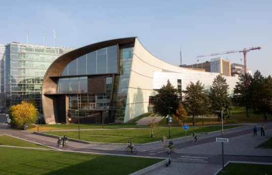
Kiasmais is a very funky location and is the home of the contemporary art museum.
At the end of the Mannerheimintie you run into the waterfront and the usual tourist fare that goes with that. A bunch of local ferries come and go, and there is a huge number of (summertime) pop up stalls to feed them and extract some money for trinkets. Add to this a Ferris wheel and a swimming pool and the place is complete.
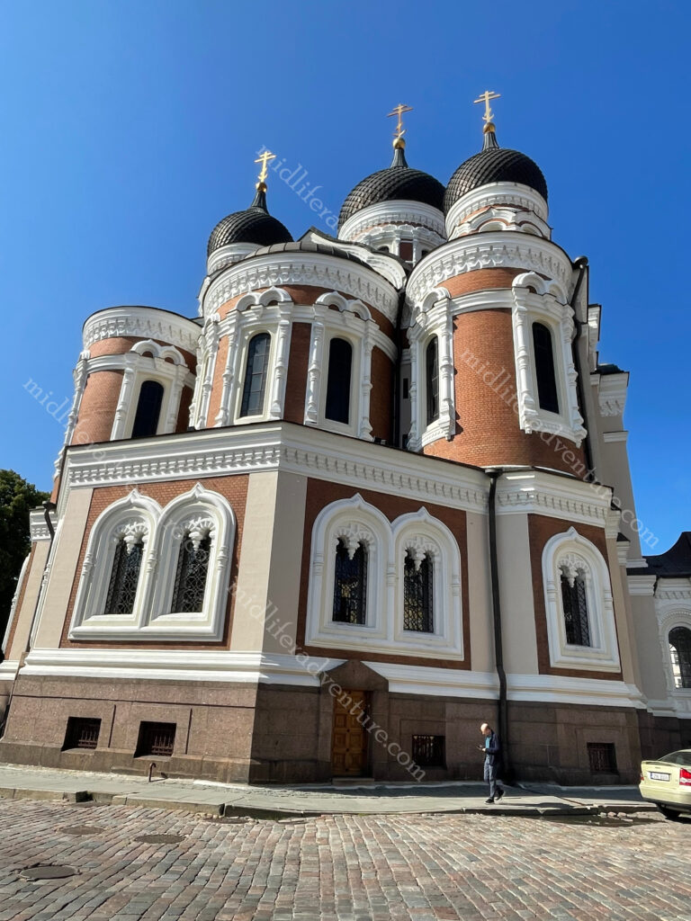
Up the hill from the waterfront you will find the highly impressive Uspenski Cathedral. This is the largest Orthodox church in western Europe and is visited by half a million people annually. The cathedral’s size is emphasized by its location on the highest hill of the Katajanokka district. The central cupola of the cathedral is 33 meters high. The cathedral was designed by a Russian architect and was consecrated in 1868.
Suomenlinna sea fortress is a Unesco World Heritage Site located on the coast of Helsinki. It is accessible by ferry and is also a suburb of Helsinki with around 800 residents. The fortress was shaped by three historic eras when it helped to defend first Sweden, then Russia and ultimately Finland. There are six kilometres of walls, 100 cannons, exciting tunnels, and beautiful parks.
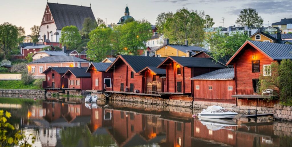
In the past, all of Finland’s houses were built of wood and usually painted red, with a few blue and yellow thrown in.
Some of these have been preserved and sit just as they did decades or centuries ago. Visiting these picturesque places is like entering a living time capsule. Within Helsinki the districts of Käpylä (about 8km north) and Vallila (about 5km northeast) will give you an opportunity to explore some of these.
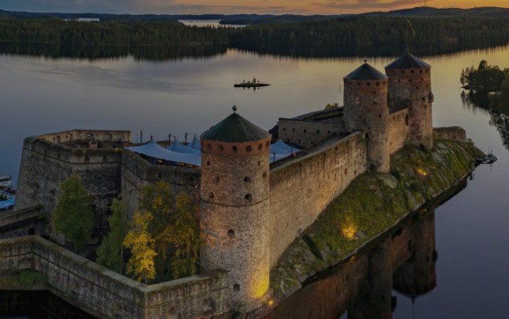
Olavinlinna Castle (also known as St. Olaf’s Castle) is one of Finland’s best known tourist sites. It was founded in 1475 and is built on an island in the Kyrönsalmi strait.
At around 400km from Helsinki we didn’t get here but it did look pretty cool. Our time in Helsinki was mixed. The town initially did not impress, but it did grow on us the more we explored. The local food and drink options were both expensive and poor, but other options (non-Finnish) were readily available and were typically better priced.
While it was perfectly nice, I don’t see either of us rushing back to Finland anytime soon. The weather was nice, the people friendly but this ticks one of those been there-done that type boxes rather than the oh my god we have to go back.
Estonia finds itself at the edge of the European Union, connecting Europe to Russia, combining the best of the Nordics and the Baltics.
Estonia consists of the mainland, two larger islands (Saaremaa and Hiiumaa), and over 2,300 other islands and islets on the east coast of the Baltic Sea. The area has been inhabited by humans since at least 9,000 BCE. The Estonian mainland was one of the last pagan civilisations in Europe to adopt Christianity (after the crusades in the 13th century).
Once again my early knowledge was limited but the writeups suggested that it was as good as Latvia and Lithuania but with a much prettier Old Town. Given that we loved the old towns of the other two, then this was something to look forward to.
The train to get us here from Riga for some unknown reason was to take us around 12 hours, but the local 5 star bus only took three. So the bus it was. A very calm and relaxed bus ride, with full WIFI all the way. A cab ride (bolt actually) to the hotel and we were ready to explore the Old Town of Tallinn.
Tallinn
Tallinn is the capital city of Estonia, with a population of a little under half a million. The town sits on a bay on the shore of the Gulf of Finland of the Baltic Sea. The oldest evidence of habitation dates back 5000 years with evidence of hunting and fishing settlements.
As an important port on a major trade route between Novgorod (northern Russia) and western Europe in around 1050 AD, a fortress was built on the hill of Toompea in what is now central Tallinn.
The Church of St. Nicholas is one of the oldest in the city, dedicated to the patron of the fishermen and sailors.
It was partially destroyed in the Soviet bombing of Tallinn in WWII. While the building has been restored, it has not been used for regular religious activities since WWII. It now houses the Niguliste Museum.
Our accommodation was just outside the old town (closer to the port, as that would be our exit) but still a short walk to the centre of things. It retains its walled, cobblestoned Old Town which is now home to cafes and shops. Our entry saw us wander down to the town where we were met with some amazingly thick brick walls that made up the medieval defences.
At this point we entered and were already impressed. We passed through the gates and found ourselves on cobblestoned streets staring at old buildings and church spires. Almost every corner you turned landed you onto a new scene with old buildings, museums, churches, medieval defences, you name it.
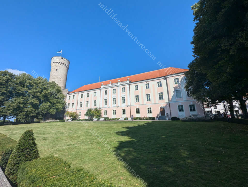
The wandering continued until we found ourselves in the heart of old town at the Town Hall Square. This has been a marketplace and the centre of town since the Middle Ages and became the centre of Old Town in the 13th and 14th centuries.T he central part of the square is the gothic Town Hall that was built in the 13th century with its 64m-high tower.
In summer the square is packed with restaurants and at times plays host to medieval festivals, and is also a venue for open-air concerts, and fairs. In winter it becomes a Christmas market, the centrepiece of which is a towering spruce tree. The tradition of celebrating Christmas festivities here dates back to 1441 when the Brotherhood of the Blackheads are thought to have erected the world’s very first Christmas tree.
Alexander Nevsky Cathedral is an Eastern Orthodox Church. It was built in 1894–1900, when the country was part of the former Russian Empire.
The cathedral is the city’s largest cupola church.
Up at the top of the hill near the cathedral you will find another defensive tower known as Tall Hermann and the old Toompea Castle.
As you keep coming down the hill you run into the Kiek in de Kok .
Meaning peep into the kitchen in old German and Bastion Passages Museum is a 15th-century defensive tower.
It is an artillery tower built in 1475 and is 38 m tall, has walls 4 m thick and still has Cannon balls dating back to 1577 embedded in its walls.
And as a 55 year old man I really should be more mature than to still find the name amusing.
Coming down the hill from the Kiek in de Kok you find yourself entering Freedom Square, at the southern end of Old Town. Freedom Square holds a Victory Column (2009) commemorating the Estonian War of Independence 1918–1920. The square also abuts St. John’s Church (built 1862–67).
And all around the outside of the Old Town is patches of the old city walls and the renovated gates that take you in and out.
We really enjoyed our time in Estonia, and in fact all three of the Baltic nations. The food has been good, and with one exception so have the beverages. Temperatures in February are terrible but by the time summer rolls around you are pulling low to mid 20’s with long days, so there is plenty of time to explore.
Our August foray into the three Baltic nations was pretty much spot on. It is technically the high season with the most tourists, but the volume of tourists coming here is way less than you will get in places like France or Italy. So even at peak times, the place is really manageable.
Latvia is one of the three Baltic states (with Estonia and Lithuania). It borders Russia (east), and Belarus (southeast) and shares a maritime border with Sweden (west).
Once again this is a nation that we both had little knowledge of before entering. Like many of the nations in and around eastern Europe, they have been at the mercy of the big nation states around them (notably Russia and Germany). It finally got its independence at the end of WWI but was forcibly subsumed into the Soviet Union at the beginning of WWII. It was invaded by Germany in 1941 and retaken by Russia in 1944.
The Singing Revolution
At the end of the Cold War the three Soviet-occupied Baltic countries of Estonia, Latvia, and Lithuania sought and ultimately peacefully won their independence. It manifested in a series of events between 1987 and 1991 where widespread dissatisfaction with the Soviet system provoked mass demonstrations (peacefully singing). The Latvian official independence occurred on 21 August 1991.
The area that is now Latvia has a history dating back to 3000 years BC. One of the last corners of Europe to join Christendom, Latvians are still very much pagans at heart. They worship nature by jumping over bonfires at Midsummer Eve, and many surnames are about birds, animals or trees. Today with a population of just under 2 million,
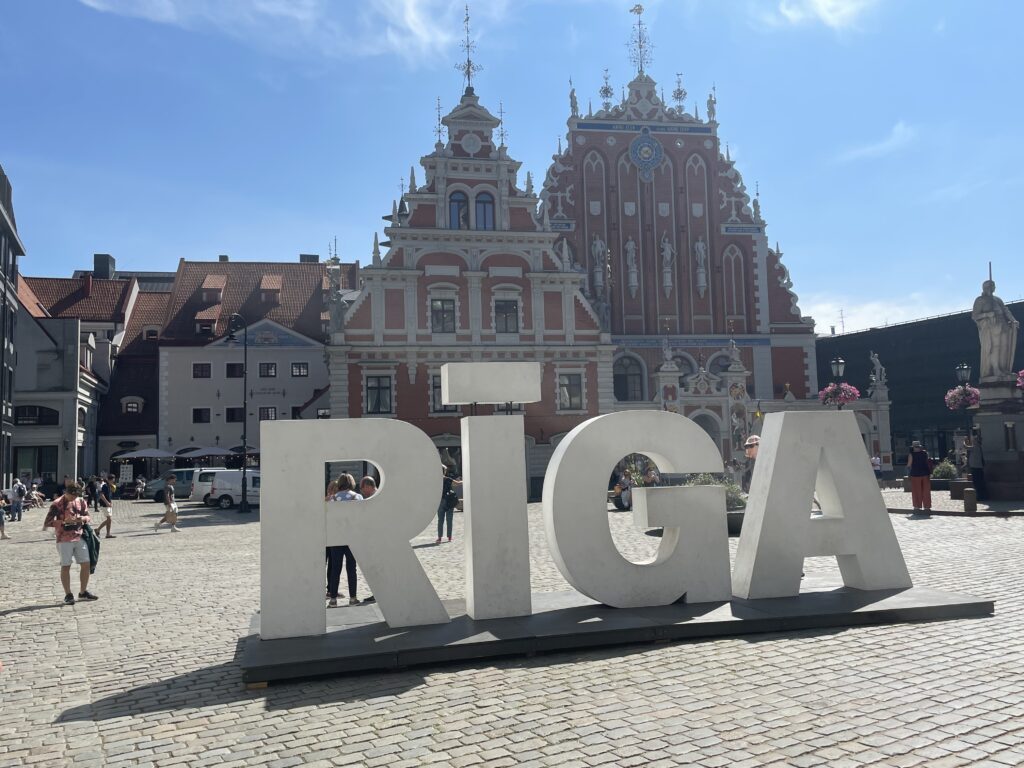
Riga
Our time throughout the Baltics was short, but the long summer days (20 hours of daylight) gave us more than enough time to look around and get our tourist on. As with most of the European older towns and cities, most of the old touristy stuff is in the central area, or Old Town area of the city. The rest of the place is just like any other modern city and the surrounding suburbs. Interesting enough, but not really blog worthy or anything different.
Our first port of call, having got off the train was to hit the Riga Central Markets. The markets are set up in a series of five WWI Zeppelin aircraft hangars. It covers a vast floor space and is Europe’s largest market. There are more than 3,000 vendors that sell an impressive range of fresh local produce. The stalls are divided neatly into each hangar with meat, fish, dairy, and vegetables all found separately.
We had limited time on day one so did a quick scoot through vowing to come back tomorrow for our lunch. This vow was based upon seeing some of the most amazing deli meats and cheeses that can be found. Add to this some really delicious looking other random items and how could you not want to go back and gorge yourself.
As it turned out this was a mistake as the next day was Monday and the food court bit was closed. There was still much of the fresh fruit and produce, and being berry season the quantity, quality and price of the berries put our measly offerings back home to shame.
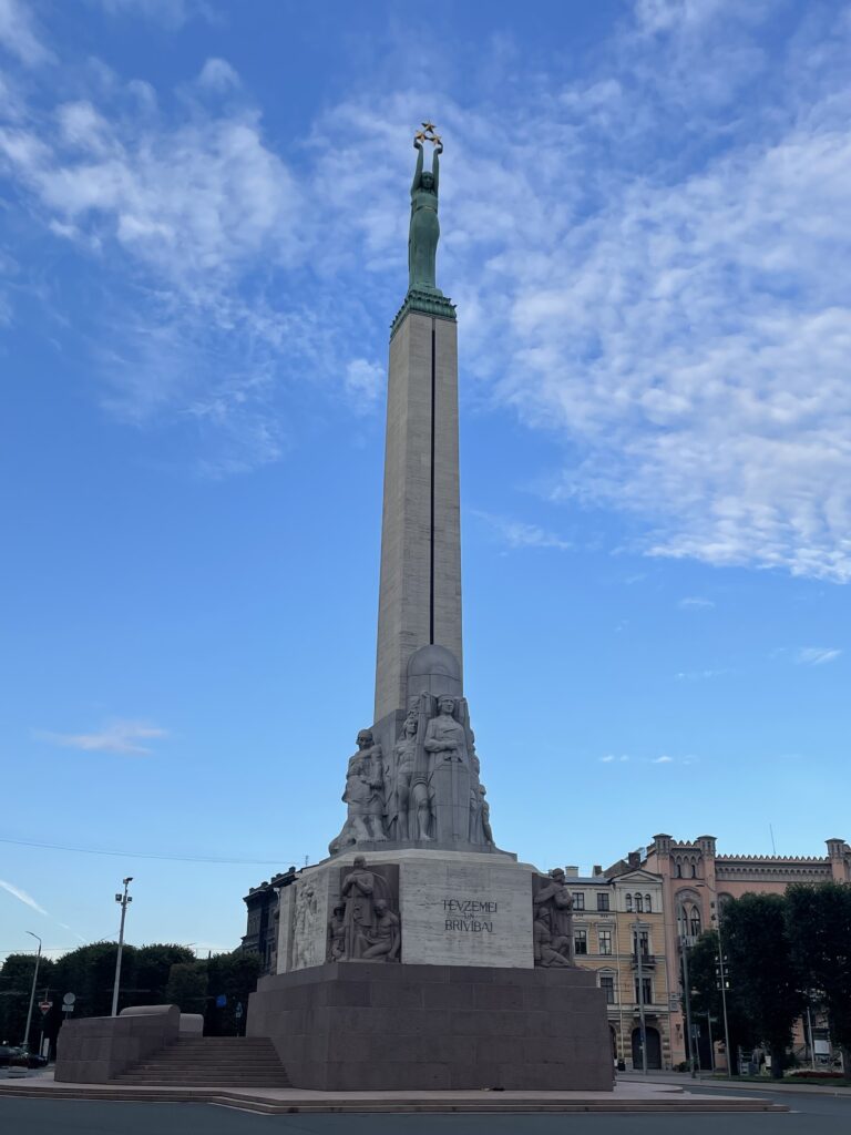
So our first evenings walk was aiming for the Freedom Monument.
It is a 42 meter tall monument honouring the soldiers killed during the Latvian War of Independence (1918–1920).
It is considered a symbol of the freedom, independence, and sovereignty of Latvia.
But to get there we found ourselves walking through the abundance of green space that is throughout Riga. For an old city it really is fantastically well laid out with a ton of green areas for the people to enjoy. Throw in the usual mix of old buildings and you immediately get a great feel about the place.
The next morning it was up and into it. So we headed down to the markets, only to be disappointed. We checked out where we would be leaving the next day (bus station) and made out way into old town once again to do the tourist thing.
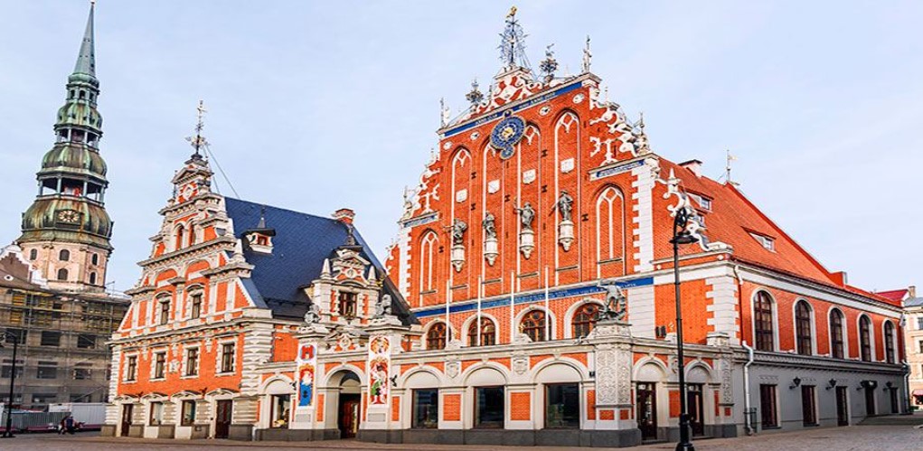
The House of the Blackheads was originally built in 1334 as a warehouse, meeting and celebration place for merchants.
During the 15th century it was used by the Brotherhood of Blackheads, a guild for unmarried merchants, shipowners and foreigners in Riga.
Over the years, many citizens of Riga became interested in the property, and carried out different works to expand and reform it, following a purely Gothic style. However, the old House of the Blackheads was completely destroyed during World War II.
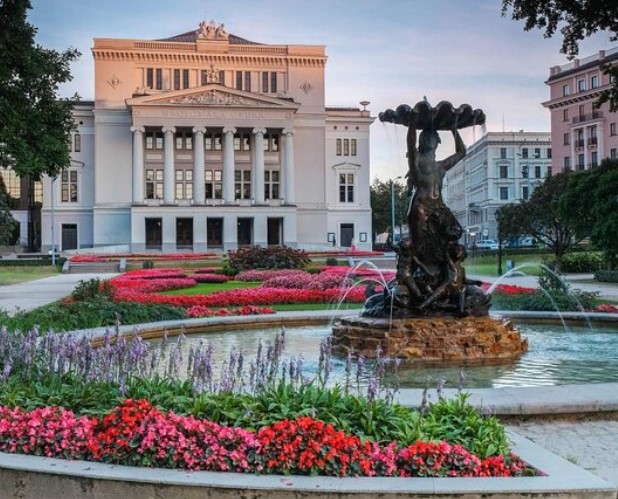
The National Opera and Ballet was a nice enough building in the midst of the gardens and green spaces.
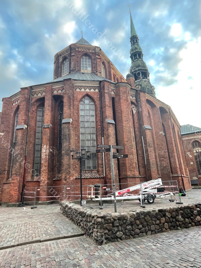
St. Peter’s Church is the highest church in Riga and a significant Gothic-style 13th-century architectural monument.
The tower is more than 130 meters tall and was completed at the end of the 15th century.
Since then it has been destroyed and rebuilt several times. In 1666 it collapsed, in 1721, lightning struck the tower and it burned down and during WWII the church and tower burned down.
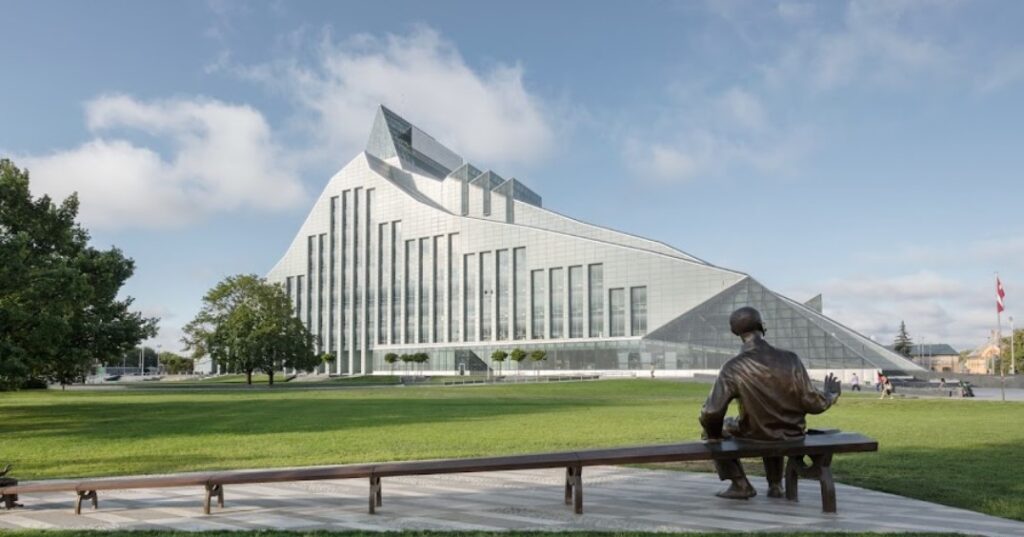
The National Library of Latvia sits on the other side of the river (the Daugava) from Old Town. The architecture is seriously cool.
The Old Town has an interesting architecture mix and most of the buildings have the status of cultural monuments. Almost everywhere you look in the old town area are some seriously nice buildings. It is really clean and well maintained and the people are happy, friendly and accommodating.
The streets and squares of Old Riga open up to countless restaurants, cafes and bars. Having come from Prague and Poland and heading north we are noticing a considerable increase in the pricing as we get closer to Scandinavia.
With almost 500 km of coast, Latvia has tons of beaches added to this over half its territory is covered by forest. As an interesting side note, it was Latvian-born tailor Jacob Davis who in 1871 in Reno, Nevada, invented denim as a tough material for trousers. He then went into partnership with Levi Strauss and made a fortune.
Latvian Beer
I am very pleased to report that the Latvian beers were very nice indeed. The price is increasing, but still not quite up to Australian pricing, but the quality of brew is much better. And much like the European standard, each ale earns its own glass,
Both Latvia and Lithuania have been lovely. Our next port of call will be to ride the bus up to Estonia where, if you believe the tourist blurb, the old town is even better again. But so far, if you are looking for a great European summer holiday, you cant really go past spending the month of August travelling in and about the three Baltic nations.
Lithuania is a developed country with a high income, advanced economy, ranking 37th in the Human Development Index (HDI) and 19th in the World Happiness Report (Australia is ranked 10 on both).
To be honest, I knew almost nothing about Lithuania before arriving here. We hopped a train from Poland and made our way to the Lithuanian capital of Vilnius. The city lies in the southeastern part of the country at the confluence of the Neres and Vilnius rivers.
Lithuanians , Poles , Jews and Belarusians have historically considered Vilnius as their cultural center. A university has been operating in Vilnius since 1579.
Legend of the Iron Wolf
According to the legend, centuries ago Grand Duke Gediminas, was on a hunting trip in the forests of Šventaragis valley around the mouth of the River Vilnia. When night fell, the party, feeling tired after a long and successful hunt, decided to set up camp and spend the night there. While he was asleep, Gediminas had an unusual dream in which he saw an iron wolf at the top of the mountain standing with its head raised proudly towards the moon, howling as loud as a hundred wolves.
The Duke remembered his dream and consulted the pagan priest about it. He was told that the dream was a direction to found a city among the hills.
The howling of the wolf represented the fame of the future city: that city will be the capital of Lithuanian lands, and its reputation would spread far and wide, as far as the howling of the mysterious wolf…’ So the Grand Duke Gediminas, obeying the will of gods, immediately started to build the future capital which took the name of Vilnius – from the stream of the rapid River Vilnia.
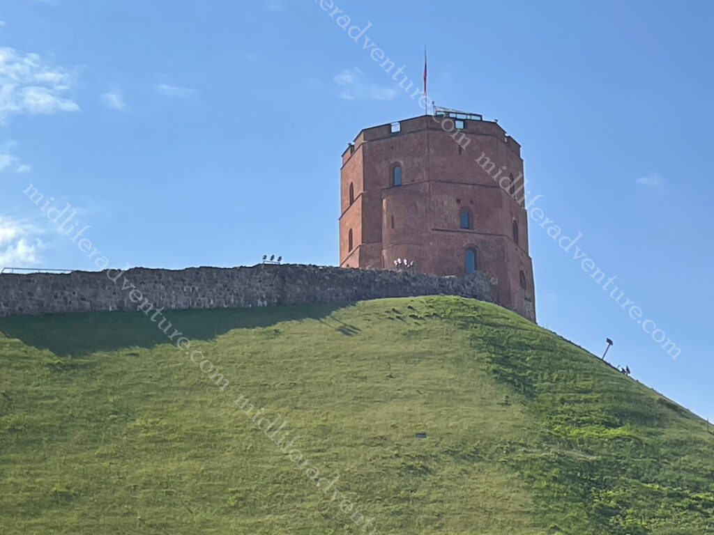
He built a fortress on the hill (Gediminas Tower) and the city of Vilnius grew up around it. You can still climb the hill and visit the Tower which provides one of the best views of this beautiful city. We however chose to pay 3 euros and use the funicular.
Hopping off the train we found ourselves in one of the cleanest and most cared for cities we have ever seen. This place was Japanese level clean and well tended for, certainly cleaner than anywhere we have ever been in Australia. Our hotel was a charming little joint, about 700m from the train station and right on the fringes of Old Town.
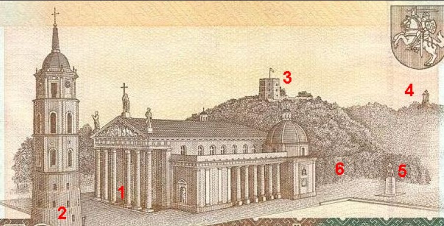
The oldest buildings in Vilnius were built in the 13th century. The main attraction is absolutely the Cathedral Square. It is not only the most important location in the city, but is also one of the most significant and widely known symbols of Lithuania.The square regularly hosts events such as: fairs and gatherings of townspeople, military parades, religious and official public events, attractions and large concerts, New Year’s salutes and exhibitions.
The main feature of the square is the Cathedral Basilica of St Stanislaus and St Ladislaus of Vilnius. The square was so important that it was the main feature on the 50 litas banknote (pre-euro), the layout included.
1. Vilnius Cathedral 2. Cathedral’s Belfry 3. Gediminas Tower 4. Hill of Three Crosses 5. Monument to Gediminas 6. Royal Palace
The Valdnieku (Grand Dukes) Palace , next to the Cathedral has been converted to house the history museum. Up the hill was Gediminas Castle Tower, which we took the funicular to reach the top. From here we got panoramic views over the city and surrounds.
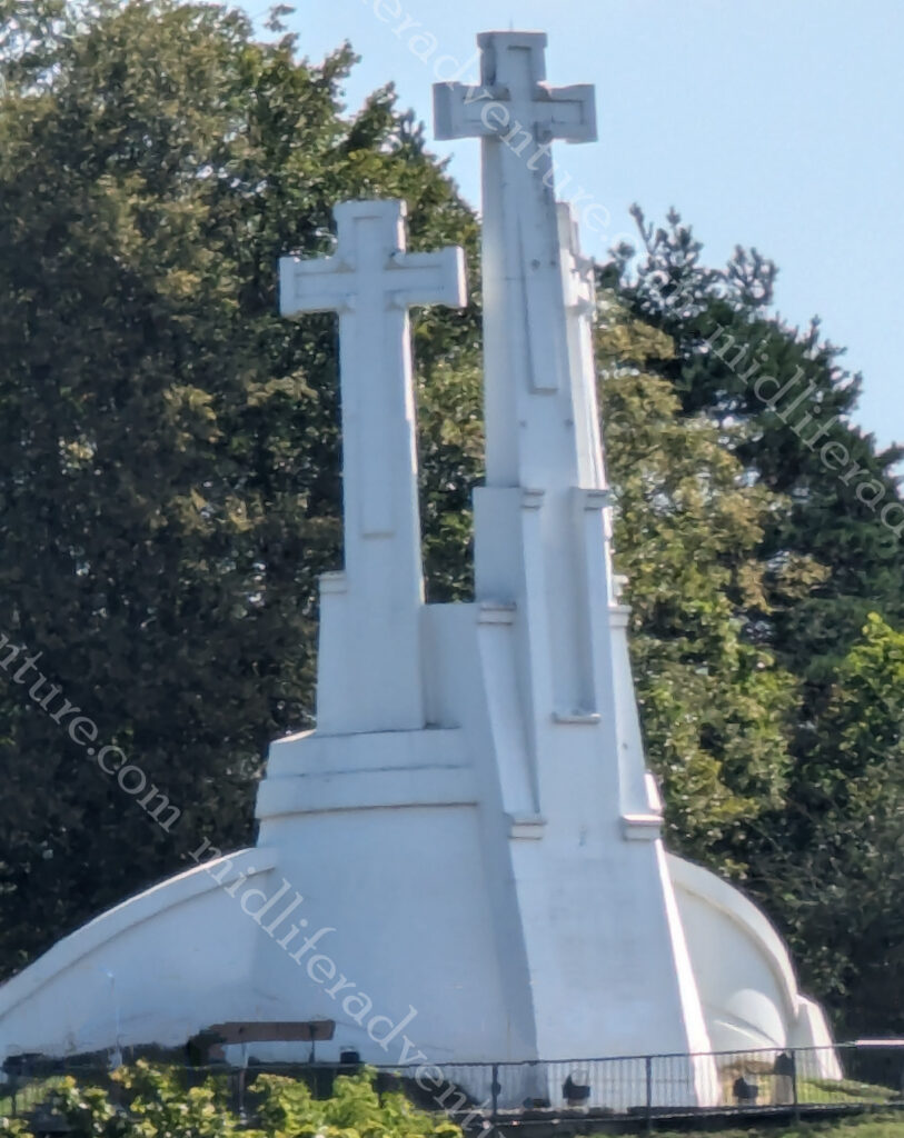
The Three Crosses memorial consists of three white reinforced concrete crosses.
The hill got its name after Franciscans died as martyrs when pagans tied them to crosses and threw them down the hill. The three crosses were erected to commemorate this event.
At the bottom of the hill and the far (back) end of the Cathedral you find yourself in the Bernadine Gardens. We did the slow meander through here on our way to St. Anne’s Church. By this time the masses of tourists had crawled out of bed and were making seeing the sights unpleasant.
In an attempt to dodge some crowds for a while we found ourselves in a local cafe/bar where Jill found her long awaited steak tartare. She had been wanting one of these since Prague, but for a variety of reasons was unable to have one up until now. So that with some zeppelins (potato/meat dumplings) washed down with an Argentinian specialty (Aperol and fresh orange juice) and a local lager.
The sheer volume of beautiful old buildings and churches to be seen in and around Vilnius is astounding. And they are all (and I mean all) in perfect condition. There is no scaffolding, no graffiti, no shoddy paint. There is a real pride to the standard of the buildings, everywhere you look.
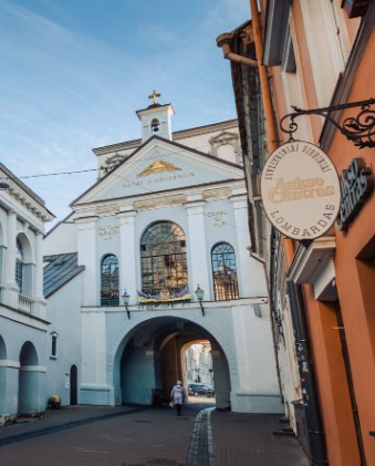
The Gate of Dawn, or Sharp Gate is a city gate that was built between 1503 and 1522 as a part of defensive fortifications for the city.
City gates often contained religious artifacts intended to guard the city from attacks and to bless travelers. The Chapel in the Gate of Dawn contains an icon of The Blessed Virgin Mary, Mother of Mercy, said to have miraculous powers.
Upon arrival we went hunting (online) about places to eat in the general vicinity of where we were. This is a common search for us on arrival in a town. The magic search phrases are restaurant near me, cheap eats near me, local food near me. We were surprised to find that the results trickled in rather than overwhelmed us.
Not finding anything that rang our bells, we decided to just wander about and see what we could see. What we found was an abundance of places to eat, but they were pop-up restaurants for the summer season. Not permanent fixtures but rather just places that took over open spaces and became an alfresco dining heaven.
The food was good, the prices were reasonable (maybe even cheap) and the setting was stunning. Warm (mid 20’s) summer evenings, cool beverages and great food offerings. This gave us some flashbacks of Spain and the way we lived back then.
To sum it all up, Lithuania was fantastic. We did not spend enough time here and will definitely put it on a list of places to come back to. August really is a spectacular time of year to visit here.
Poland is bounded by seven nations and over the years (about a thousand of them) has been beaten up by almost every nation seeking to flex its military muscle. It had its day in the 1500’s but then became divided again by the next lot trying to flex.
After centuries of subjugation, Poland finally (or at least most recently) became independent in 1989. Under communism (after WWII) Poland became highly industrialised with mining, steelworks, and machinery production prevalent. After independence it moved to a free market economy. Since joining the EU in 2004 Poland’s economy has grown rapidly.
Today Poland has a population of around 38 million most of which are Roman Catholic but the Polish culture is heavily influenced by Slavic folklore.
Our trip to get to Poland involved an 8 hour train ride from Prague in the Czech Republic, through the Czech and Polish countrysides which was very pleasant. This trip delivered us to he town of Oświęcim. We spent the night there (having a nice local meal of Pierogi) and saved ourselves the drama of the crowds the next morning (visiting Auschwitz) as most of the groups set out from Krakow.
We were booked in for the 9am English speaking tour, which as it turns out was a good thing. The tours through here are booked (and sold) out for weeks in advance. We were there on 1 August and had we not booked well in advance, the next available booking was not until the 15th. So long story short, if you want to come, make sure you book well in advance.
The next thing that struck us was the total disrespect of the tourists. We had heard stories of Instagrammers posing for sexy photos on the railway tracks but on walking in we were issued with out tour group sticker. On the walk in there were thousands of these stuck on every light pole within cooee of the site.
Auschwitz
This was Jill’s main focus in coming here. Auschwitz was a complex of over 40 concentration and extermination camps operated by the Nazis during WWII. To say that visiting here was confronting is massively understating the power that this place holds. It is the site of the single largest mass murder event and has become a symbol of terror, genocide and the Holocaust. The exact number of victims is unknown but it is over one million and it is known that many Jews, Poles and gypsies died here.
The museum consists of two parts: Auschwitz I (the first and oldest camp) with the number of prisoners fluctuating between 15-20,000 and Auschwitz II, Birkenau which held more than 90,000 prisoners in 1944. Birkenau was the main extermination camp and represented the “Nazis’ Final Solution to the Jewish question”. The term was a euphemism for the annihilation and genocide of the Jewish people.
Four large gas chambers were built at Birkenau, capable of killing up to six thousand people each day. The gas chambers were disguised as showers, meant to persuade the victims that these were disinfection measures which they had to undergo before they were sent to work in the camp.
After the arrival of a transport at the ramp in Birkenau, the process known as selection took place. SS officers decided who would be taken to work, and who would be sent directly to the gas chambers. The prisoners selected for slave labour (16-30 year old fit people) were sent to one of the many auxiliary camps with the aim of extermination through labour.
The camp has areas set aside for the things that were confiscated from those about to be killed. Eye glasses, suitcases, shoes, clothes and even the hair shorn from corpses. In addition to this there were many photographs of the people that had been in the camps. Needless to say, the thought of taking photos of such things just felt wrong. So Jill and I just silently walked around and took in the enormity of what being at this place actually represented.
But even then, towards the end of our tour of Birkenau we went through one of the dormitories that housed 700 people, and upon entry saw graffiti by fleabags dated 2024. In this place many of the bricks had been defaced and people had deemed it important to scratch their name into the bricks.
With an incredulous look, I showed the guide and she responded that just last week a 20 year old German girl was caught doing exactly the same thing. I asked if they were severely punished, her response was that she hoped so. This then sparked a conversation about the public naming and shaming of people for such despicable acts.
There is no way that I can say that visiting Auschwitz is an enjoyable or pleasurable experience. But it is something. in hindsight, that both of us are glad that we have done. It is something that should be experienced (one time only).
Krakow
Having explored Auschwitz, we walked back to our hotel, collected our bags and hopped the local train to take us through to the town of Krakow. Krakow is one of the oldest (and second-largest) cities in Poland and was at one time the capital. The Krakow old town (where we were staying) was granted UNESCO world heritage listing back in 1978, one of the world’s first places designated this way.
Our introduction was not as pleasant, as the hotel that we had booked (and had confirmed) was shut. We arrived in the rain and stood outside, (in the rain) ringing the bell and buzzer and calling the website phone numbers. All to no avail. After 30 minutes we walked around the corner, found a similarly priced hotel, that was open, and checked in.
Krakow has been a busy trading city in Europe dating back well over 1000 years. During WWII the city was largely spared from aerial bombing and destruction. This means that the older and more historic elements of town are largely intact.
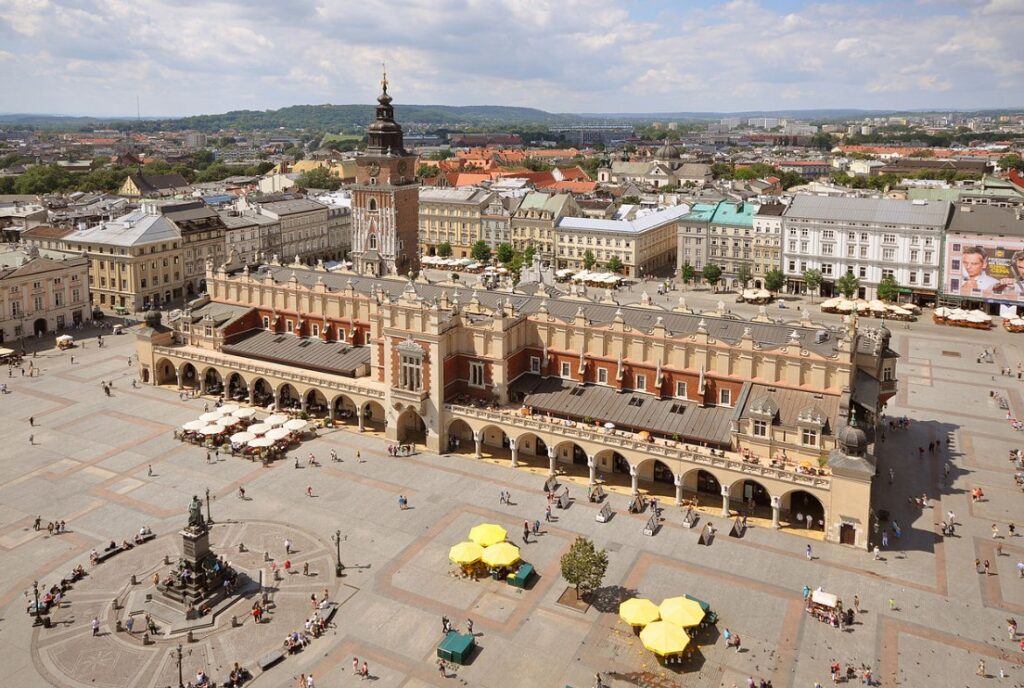
Rynek Glówny is the Central Square of Krakow it is a huge 10-acre square in the centre of largest in any of Europe’s medieval cities. The center of the square is dominated by the Cloth Hall.
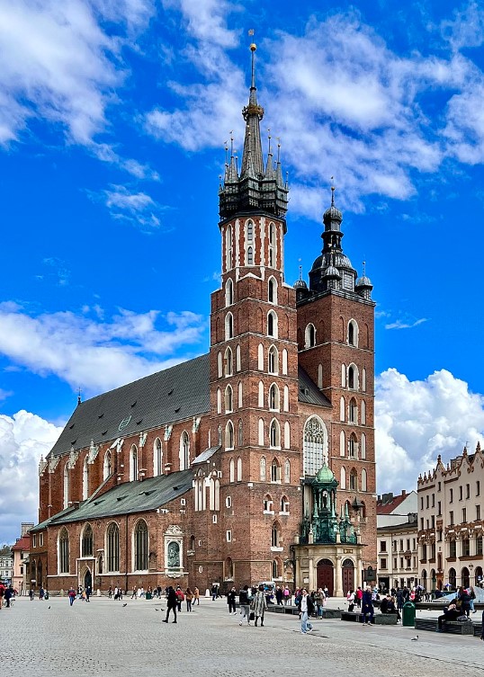
At 80 m tall the 14th-century Gothic Basilica of the Virgin Mary is pretty hard to miss.
On the hour, every hour a trumpet signal (called the Hejnał mariacki) is played from the top of one of the two towers.
The tune is cut short mid-stream. This is done to commemorate a famous 13th century trumpeter who was sounding the alarm of a Mongol attack when he was shot in the throat.
This one we did not go to but when I saw it on the attractions list I had to include it for my sister Karin, who is a glass artist. It was the muWi Stained Glass Museum (Muzeum Witrazu) where exhibition spaces intertwine with the old (but still functioning) stained glass workshop, functioning since 1902. Here you can do a guided tour of the historic workshop, directly above the heads of artists and craftsmen.
If you are super keen you can pay extra and have a 2 or 3 hour workshop ($93-130) with a master craftsmen and make your own stained glass souvenir. There is a third 2-4 day option for a bit over $1100.
For the younger crowds there is also a Lego Museum (Bricks and Figs) an Arcade Museum (a private collection of over 150 arcade games and pinballs available on Free Play). The oldest table game dates back to 1936 but the main focus is on the classics of the 80’s and 90’s. Then there’s Wheels & Heels a collection of miniature cars and iconic dolls from around the world.
And if you are more adventurous you can always head off to the Lost Souls Alley (a haunted house experience), Axe Nation (an axe throwing club), Krakow Shooting Academy (choose from dozens of weapon models from WW1 to the modern era).
Our limited time in town did give us enough time for a lovely wander through the old town. More importantly, it did get us to a charming local restaurant (recommended by our hotel) in a basement in the heart of old town. Starting with a local cider aperitif, we followed with the soup (in a bread bowl), cheese and pierogi mixed entree and topped off with a wild boar main.
Our time in Krakow was short but it was lovely, and was really quite well priced.
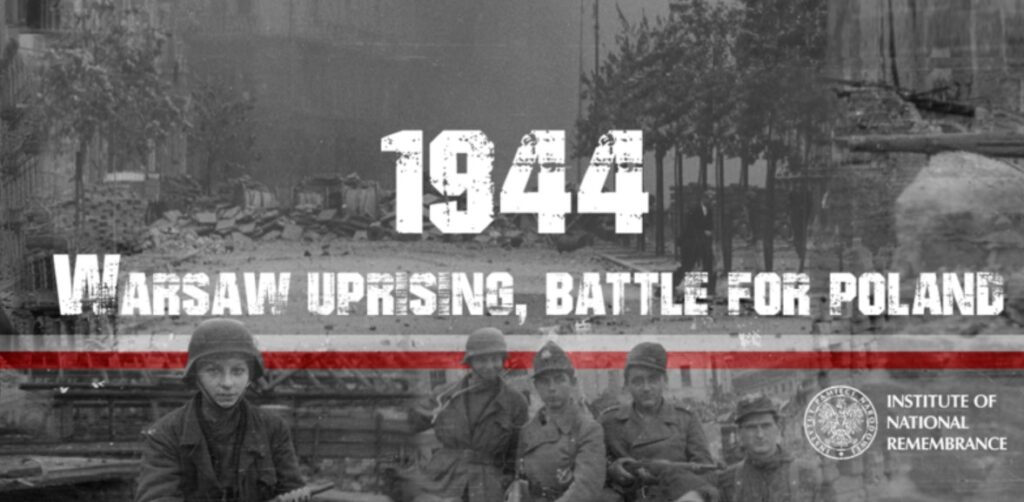
Warsaw
We really only transited Warsaw. We had planned to come and stay for a while but the prices were wildly overpriced. We searched and tried to find out why, but could not come up with an answer. As we were going through Auschwitz it became apparent. Our timing was such that we were in Auschwitz on the 80th anniversary of the Warsaw uprising.
The Warsaw uprising was a major World War II operation to liberate Warsaw from German occupation.
It occurred in the summer of 1944 and was led by the Polish underground resistance. It was timed to coincide with the retreat of the German forces from Poland ahead of the Soviet advance.It was the single largest military effort taken by any European resistance movement during World War II.
According to Wiki the uprising was fought for 63 days with little outside support. The Red Army did not reinforce resistance fighters or provide air support. Declassified documents indicate that Joseph Stalin had tactically halted his forces from advancing on Warsaw in order to exhaust the Polish Home Army and to aid his political desires of turning Poland into a Soviet-aligned state.
Poland was actually much better than I had imagined. Auschwitz, while confrontational was fascinating. Krakow was really nice and largely untouched by any of the many wars that have taken place here and Warsaw showed enough signs to suggest that we could easily come back for a more detailed visit.
We made it to Inner Mongolia the first time around, but the logistics of getting to Mongolia proper were just too hard to manage back then.
Mongolia is a basically an oval shaped country (2,400 km E-W and 780 N-S) wedged between China and Russia. Three quarters of the place is open pasture (The Steppe) which supports the huge herds of grazing animals for which the country is known. Mongolia is considered the world’s least densely populated nation, with 3.3 million people spread over 1.5 million square kilometres.
While many countries are denying or denouncing their imperial past, Mongolia is bucking this trend vehemently. They have proudly and brazenly embraced it. So much so that everything is about the great Mongol empire and their most famous of leaders.
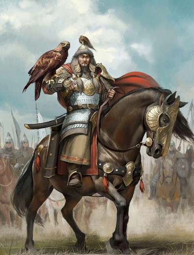
Genghis Khan (1162-1227) known locally as Chinggis Khan, was a warrior-ruler and one of the most famous conquerors of history. He first consolidated the disparate tribes into a unified Mongolia and then expanded the empire through to the Adriatic Sea.
The empire lasted almost 400 years after his death. Mongolians see him as a symbol of their country’s strength and resilience.
The Mongolian nation was officially proclaimed in 1924, with the capital set around the main monastery of the Bogd Gegeen (spiritual leader) and was renamed Ulaanbaatar (“Red Hero”). While technically ‘independent’, for the first 70 years it was actually a one-party state closely tied to Russia (the Soviet Union). It received all technical, economic, and military assistance from Russia and generally followed Russian guidance in all matters political and economic, while building a socialist society.
After the collapse of the USSR, Mongolia ended the monopoly and embraced free multiparty elections, coalition governments, a new constitution, and installed greater cultural and religious freedoms.
Our entry saw us flying in to the Chinggis Khan International Airport (virtually everything here is/was named after Chinggis). This saw the first actual panic occur in the time since we have been away (600 days ago). Having no local currency Jill hit the ATM (as usual) but mid-transaction she was hit by the blue screen of death as the machine shut down and rebooted itself (with our card inside). Needless to say, some internal panic ensued over the next few minutes. But our card eventually spat out and we used a different machine, got our money and started the usual SIM card and taxi negotiations.
The airport is about 50 km out of town and provides you with an excellent opportunity to get a true sense of what you are getting yourself into. Flying in there is a single bitumen road (three lanes wide in each direction) and everything else is a dirt road or a paddock. Driving on the bitumen road, you pass gers (the local Yurt version), herds of cows, horses, goats and some truly stunning scenery.
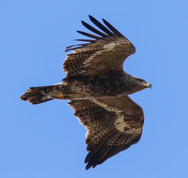
The cab ride in was astounding with some of the most amazing landscapes, sculptures and wildlife. Our first glimpse of a steppe eagle in full flight was just stunning. These huge muscular birds are quite the sight and can be easily spotted just glancing out the windows.
After a while the dirt roads on the sides give way to the city, enter the appearance of some amazing (and sometimes a bizarre) statues along the roads. The first thing that catches your eye is the abundance of Prius vehicles. Quite literally every second vehicle on the road is a Prius.
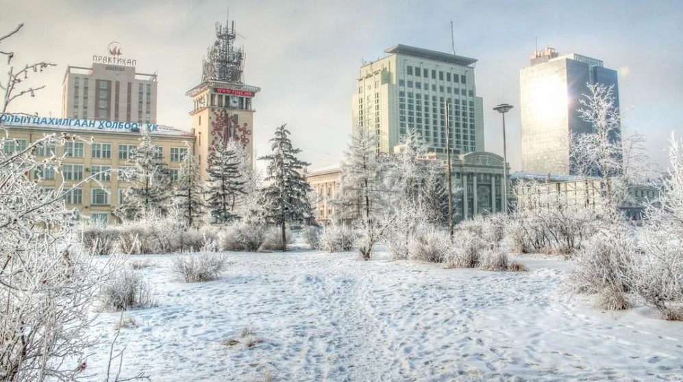
Ulaanbaatar is home to half of Mongolia’s three million population and is the coldest capital city in the world with heavy snow and cold lasting for three months.
As we were here in early summer, we missed all of this cold weather, and enjoyed some cool evenings and pleasant days in the mid-20’s. The cold is due to:
its high elevation (1350m),
relatively high latitude,
being hundreds of kilometres from any coast,
the effects of the Siberian high.
These factors combine to deliver winter temperatures of -40 degrees Celsius. With a temp range from -40 in winter to plus 35 in summer, Mongolia has an extreme and inhospitable climate where only the hardiest survive. Forty percent of the population still live as nomadic herders.
Ulaanbaatar (or just UB for us well travelled types) is surrounded by 4 sacred mountains (Bayanzurkh, Bogd Khan, Songinokhairkhan and Chilgeltei). South of UB, Bogd Khan Mountain is proclaimed as sacred and was declared a protected area in 1783, which made it the oldest national park in the world.
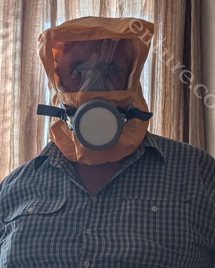
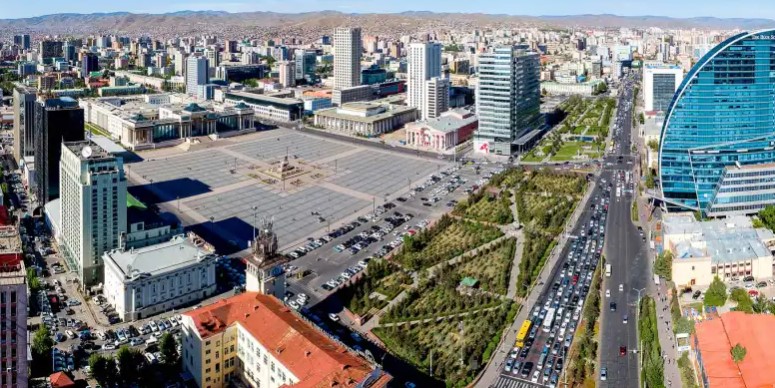
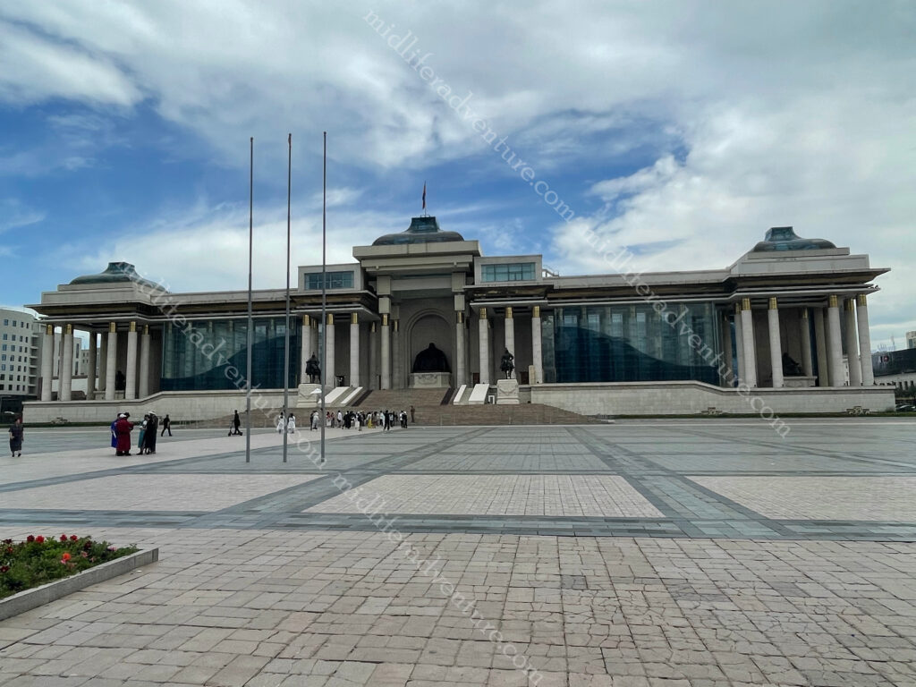
Our accommodation was at a boutique hotel, quite literally in the middle of everything. We were directly opposite the national museum, a block from the Chinggis Khan museum, right next door to the Parliament building and Sukhbaatar Square. This meant that our step count would not be high, but we were sure to see everything (around town at least). Bit worried about the gas mask in the cupboard though.
Almost immediately opposite our hotel was the National Museum, which would also be our first port of call. It was a great collection of all things Mongolian with a particular emphasis on the national dress over the years. Given that the Chinggis Khan museum was only a block away, that bit was a bit light on. But I was interested to find out that Mongolia had its own astronaut (Jügderdemidiin Gürragchaa) who went into space in 1981 as part of the Russian space program.
Being a Tuesday, the Chinggis Khan museum was shut so it was off to Sukhbaatar Square.
In the early 1800s, when UB was still in its infancy, a large square was constructed as the city’s center with the name “Great Freedom” (Ikh Choloo). After the People’s Revolution of 1921, the area was called “Indrin Square” and in 1946 was renamed “Damdin Sukhbaatar Square” to honor the Mongolian independence hero. It was renamed to Genghis Khan Square in 2013 and changed back in 2016.
The square houses statues of Genghis Khan, Sükhbaatar, and Sanjaasürengiin Zorig (who helped lead the democratic revolution of 1990).
At the top (north) of the square is the Mongolian Parliament Building and the square is surrounded by some great soviet era old buildings that include, the stock exchange, the cultural centre (Соёлын Төв Өргөө), state opera and ballet and the usual big (local) banks.
National Parliament of Mongolia is the home of all government related stuff. The front of the palace has statues of Genghis Khan, Ögedei Khan, and Kublai Khan.
The statue of Genghis Khan is guarded by two of his generals Muqali and Bo’orchu on horseback.
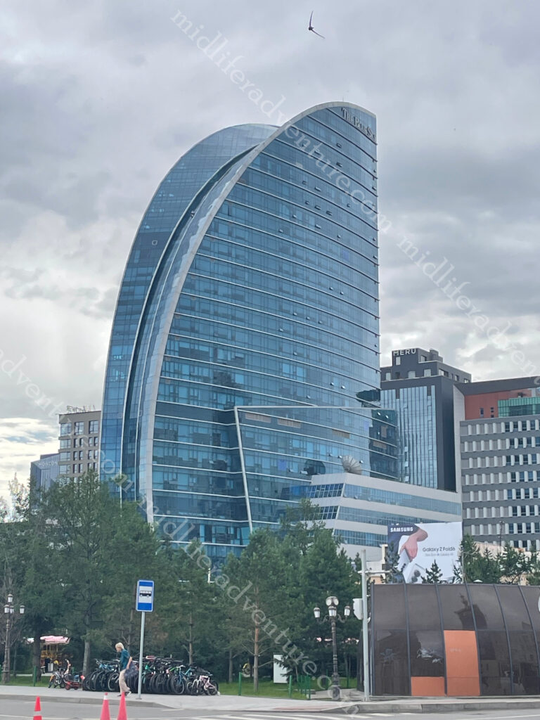
At the southern end of the Sukhbaatar Square you find the bizarrely out of place Blue Sky Tower (Хөх тэнгэр цамхаг). This is an ultra-modern 25 story, 105 meter, steel and glass skyscraper that houses luxury apartments, a 200-room hotel, restaurants, and office and conference space. To say it stands out is an understatement.
The second day it was off to the Chinggis Khan Museum. As you can imagine, this one had much more about the development of the empire and the tools of war, as opposed to the traditional costumes from the day before. Until recently there was no photos allowed but now for about $20 you can purchase an authorising lanyard and take some happy snaps.
Next stop for us was down to the State department store. Back in the soviet days this was the only (official) place to get your items. It was written up as an attraction in its own right. For us it was a six storey shopping hell. It was basically a Westfield, with all of the usual stores, selling pretty much what every shopping mall sells. The fur section was a little bit special and I did spend some time looking at a fur stoal made from a white arctic fox with head intact.
Our next day was meant to be off to the Palace (officially the Winter Palace of the Bogd Khan) but it was about a 2.5 km walk and the weather (rain) set in fairly nastily. Add to this the bride not feeling 100% in the preceding days, we decided to hide and boycott until the next day. Built between 1893 and 1903, the palace is where Mongolia’s eighth Living Buddha, and last king, Jebtzun Damba Hutagt VIII (often called the Bogd Khan), lived for 20 years.
To say that the palace has seen better days in underselling the situation. Extreme temperature fluctuations (-40 to +35) has seriously taken its toll on the older buildings. Despite this the Palace houses some important items (such as the Mongolian Declaration of Independence from China in 1911) as well as some gifts received from foreign dignitaries. Some of these include: a pair of golden boots from a Russian tsar, a robe made from 80 foxes and a ger lined with the skins of 150 leopards. The Bogd Khan had a thing for unusual wildlife and there is an impressive display of stuffed animals in the palace. At one point the Bogd purchased an elephant from Russia for 22,000 roubles.
Hidden in behind the Blue Sky tower you can find the Choijin Lama Temple Museum. This is a complex of five temples with elaborate paintings, colorful masks, and ornate statues. The monastery was built between 1904 and 1908 for the Choijin Lama, a brother of the Bogd Khaan who became Mongolia’s first leader after independence.
Most of the top things to do in UB are actually outside the city. So the next day it was in a car and out of town on a day trip in and around the natural beauty that is Mongolia. A hundred Aussie bucks bought us a car and driver for the day with an itinerary to boot.
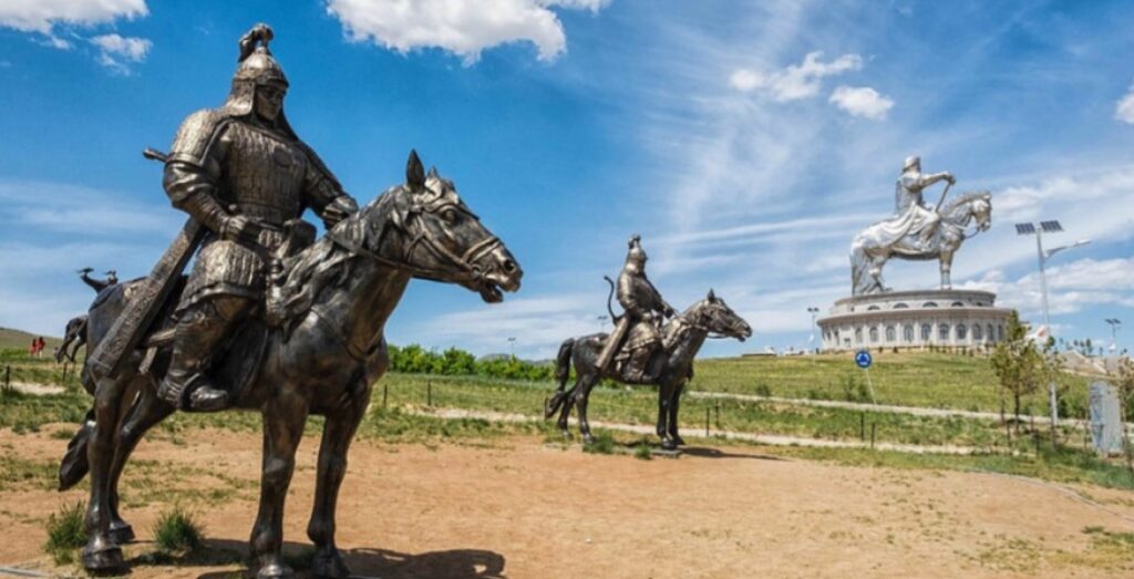
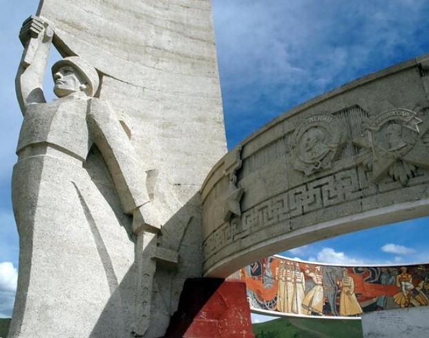
The most famous of thing to see is the Genghis Khan Statue Complex, about 54 kilometers outside UB. At its heart stands a 40 meter tall statue of guess who, perched atop a 10 meter pedestal.
The complex stands on the bank of the Tuul River and was built to commemorate the 800th anniversary of Genghis Khan’s birth. It is the world’s largest equestrian statue. The base consists of 36 supporting columns, representing 36 great Khans (Mongol kings) with the entrance gate to the complex being decorated with statues of the nine generals (noyons) of Genghis Khan.
To say that you can see this thing from afar is a tad obvious. Construction took three years, cost $4 million and used 250 tons of stainless steel. It opened in 2008, and the interior houses an art gallery, museum, a dress up shop, and the obvious souvenir and coffee shops, etc.
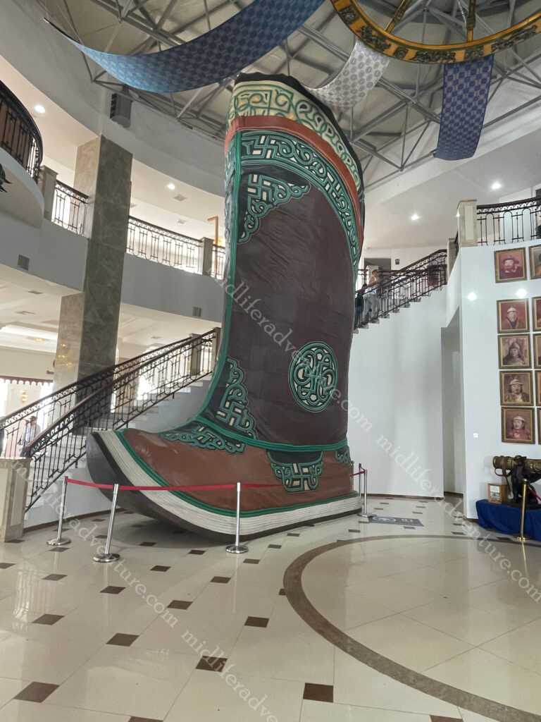
Most importantly, it houses the world’s largest boot (maybe). I say maybe because google doesn’t list it as such. This one is 9 meters tall and the one listed on the internet (in the USA) is only 16 foot (about half the size) tall.
There is probably some weird rule as to why this doesn’t count, but I don’t know.
Apparently, the current version of the complex is just phase one. Over time it is planned to place a whole town of the yurts to make up a thematic town, revealing all sides of Mongolian life. The complex was built here (Tsonjin Boldog) because according to legend, Genghis Khan found a whip in this area. In Mongolia, people believe that man finding a whip is a sign of fortune, good destiny, and occasion. The statue faces east, the direction of Genghis Khan’s birthplace.
After the statue it was off to the Terelj National Park. This is one of the most accessible national parks in the country, being about 70 km northeast of UB. It is known for its picturesque alpine scenery, interesting rock formations, and outdoor activities.
In short, we spent hours driving through some of the most amazing scenery that you can come across. We stopped at some obvious spots (like turtle rock) for photo opportunities, but in reality almost every second presented photo opportunities (the single lane road just wasn’t designed for stopping).
A small portion of the National Park has been developed for tourists, with hotels and tourist ger camps set up. These obviously come with the associated restaurants and souvenir shops. In addition there is a bunch of locals set up to take bus loads of (predominately) Koreans on horseback rides, hiking, rock climbing, swimming, rafting, and bird-watching trips.
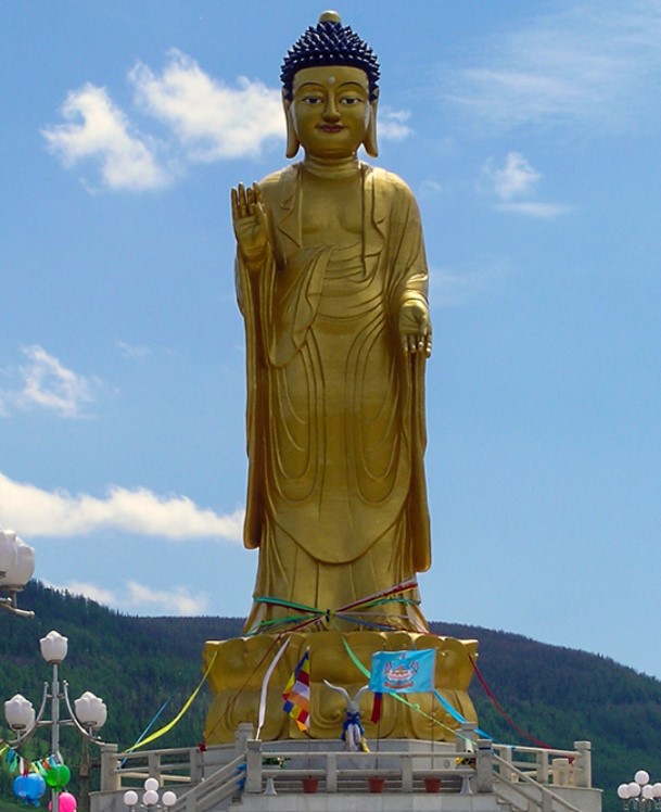
Our next stop was to be the Zaisan Memorial which was built on a hill to just south of town to commemorate those Mongol and Soviet soldiers killed in World War II. Sadly the mountain it stands on was shut to shore up some landslide activity – so we missed out.
While we missed out on climbing the mountain, at the point we got turned around, we had a perfect view of the big buddha.
Built in 2006 the Buddha statue looks through the entire UB city and protects the city from any danger.
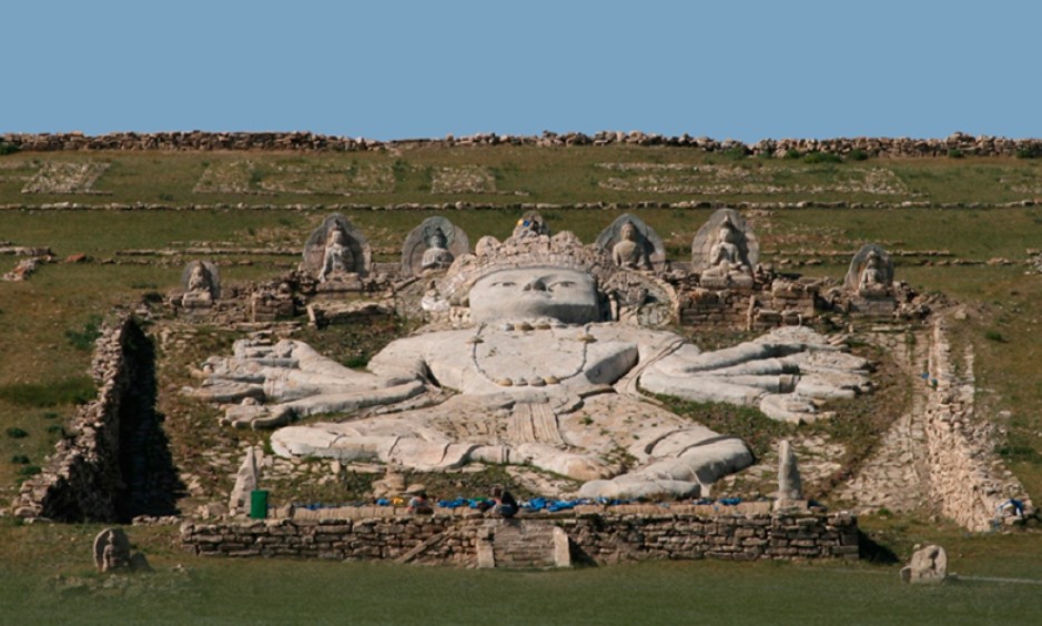
Speaking of missing out, Eastern Mongolia has the Ikh Burkhant complex which has a 90 meter high stone Buddha built into the hillside. It was built between 1859-1864.
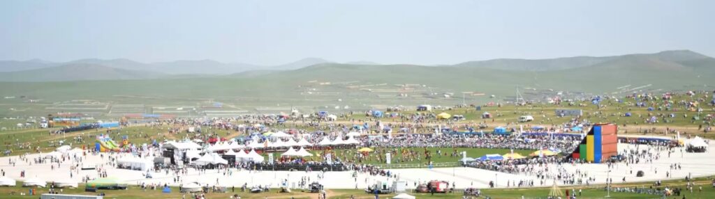
Naadam Festival
Sadly we missed this one by a couple of weeks (we were at Brads birthday when it was on), but this is the main festival of the nation. It is the most important holiday and biggest event on the Mongolian Calendar. The Naadam Festival includes the “Three manly games”. These are sports competitions of Wrestling, Horse racing and Archery. Despite the name, women participate in the archery and horse-racing games, but not in Mongolian wrestling.
The main festival is held in the capital UB, however smaller versions are replicated though the provinces and villages (soums). It begins with an elaborate Opening Ceremony featuring dancers, athletes, horse riders, and musicians.
Mongolian Wrestling (bökh), has no time or weight limits, and bouts end when one of the opponents hits the ground. Bökh wrestlers’ costume consists of 2 parts: upper part is called zodog and the lower part is called shuudag. The zodog & shuudag are usually bright red or blue. Wrestlers complete their looks with Mongol hat & Mongol boots.
Mongolian horse racing as featured in Naadam is a cross-country event, with races 15-30 km long. The riders are children (girls and boys), with the oldest being 10 years old and the youngest only 4. The racing routes are straight requiring less navigation and more speed and endurance.
Traditionally, children rode without saddles but modern consideration for the jockeys’ safety has introduced regulations requiring saddles, stirrups, helmets, vests, knee and elbow pads. In addition to this each rider must be covered by accident insurance.
Mongolian Archery involves 360 targets that are put up for the archery competition. In this competition, both men and women participate; men fire 40 arrows from 75 meters away while women fire 20 arrows from 60 meters away. The winners of the contest are granted the titles of “National marksman” and “National markswoman”.
Mongolian traditional homes – “the Ger or Yurt” are important part of Mongolian national identity. But, in rapidly growing UB’s life, you can see the ger districts on the fringes.
Mongolian Statues
Almost everywhere you look as you wander about town you end up running into some pretty interesting statues. Some are of the famous Khans etc, but many others are just there. they can be found at almost every intersection. Some you have to hunt for while others jump out at you. My favourite was the Predator riding an Alien motorcycle, or the whole caravan of camels in the middle of a roundabout.
Taxis
While wandering the city we did learn the trick of the local cab system though. Basically, every car is potentially a taxi, just wander along with your arm dangling out a bit and somebody will stop. I suggest you are more organised than I was, as my pronunciation left much to be desired. Maybe take a screenshot of where you want to go and just show the driver, knowing the distance in advance makes the price calculation and end of trip communication much easier. The fee is 2000 tugrik (about a 90c) per kilometer and I just rounded up the parts of a kilometer based on the google map distance.
The Black Market
Our last full day saw us venture to Naran Tuul or the Black Market (using the above taxi method). As sketchy as a Black Market sounds, nowadays it is all pretty legit. There are warnings of pickpockets and bag snatchers and scammers trying to elicit an entrance fee to the free market, but none of these eventuated for us.
What really strikes you about UB’s Black Market is how much and what there is for sale. This is a market aimed at the locals and seeing what is on sale makes you realise how different Mongolia is to the rest of the world. The size of the material section was huge. Rows after rows of material and sewing gear. Clearly many of the clothes remain home made.
For me most of the interest lay in the boots. Mongolian boots are truly a thing of beauty, not just the pointy toed traditional types (gutuls), or the warm felt Ugg boot type things, but just the normal everyday boot. They are magnificently made, of the softest leather, and are really nicely styled.
This is the big drawback of this sort of travel, our souvenirs and trinkets must be small and light. Otherwise the likelihood of me leaving with some fantastic boots was high.
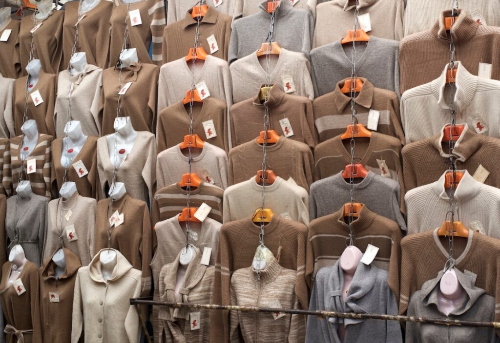
Mongolian Cashmere
Mongolian cashmere is widely considered to be the best in the world. The harsh climate makes it an ideal environment for cashmere goats to grow thick undercoats.
Cashmere is a type of wool obtained from the soft undercoat of the cashmere goat. The wool is harvested during the spring molting season when the goats naturally shed their undercoat. Mongolia is the largest producer of cashmere, accounting for more than 50% of the global production., with India, China, Iran, Afghanistan, and Kazakhstan producing the majority of the rest.
And here you can find it almost everywhere you look. Like everything else in Mongolia, it is mot cheap, but the quality is exceptional.
Mongolian Food
Food in Mongolia is certainly a melting pot. Today, you can get just about anything you want and the quality is pretty good. If you look at the surrounding nations and those that at one time made up the empire, it is pretty normal to think that the variety would be wide.
There are plenty of local restaurants offering (some) traditional dishes that are worth the effort in tracking down. And some other traditional dishes that maybe only for the more adventurous (more about that below). Veggies in summer were tough to find and I assume that this is worse in winter. Many of the local dishes are high in meat content (but there’s nothing wrong with that).
Chinese is everywhere, as is burgers and pizza, Turkish, Italian, Indian, Korean and Japanese. Then the surprising ones come into play Mexican was the one that threw me most. But we had Uzbek, saw Azerbaijani, Kyrgyz, Irish pubs, Vietnamese, Spanish tapas and a surprising number of vegan and vegetarian restaurants (we didn’t go there).
Local Dishes
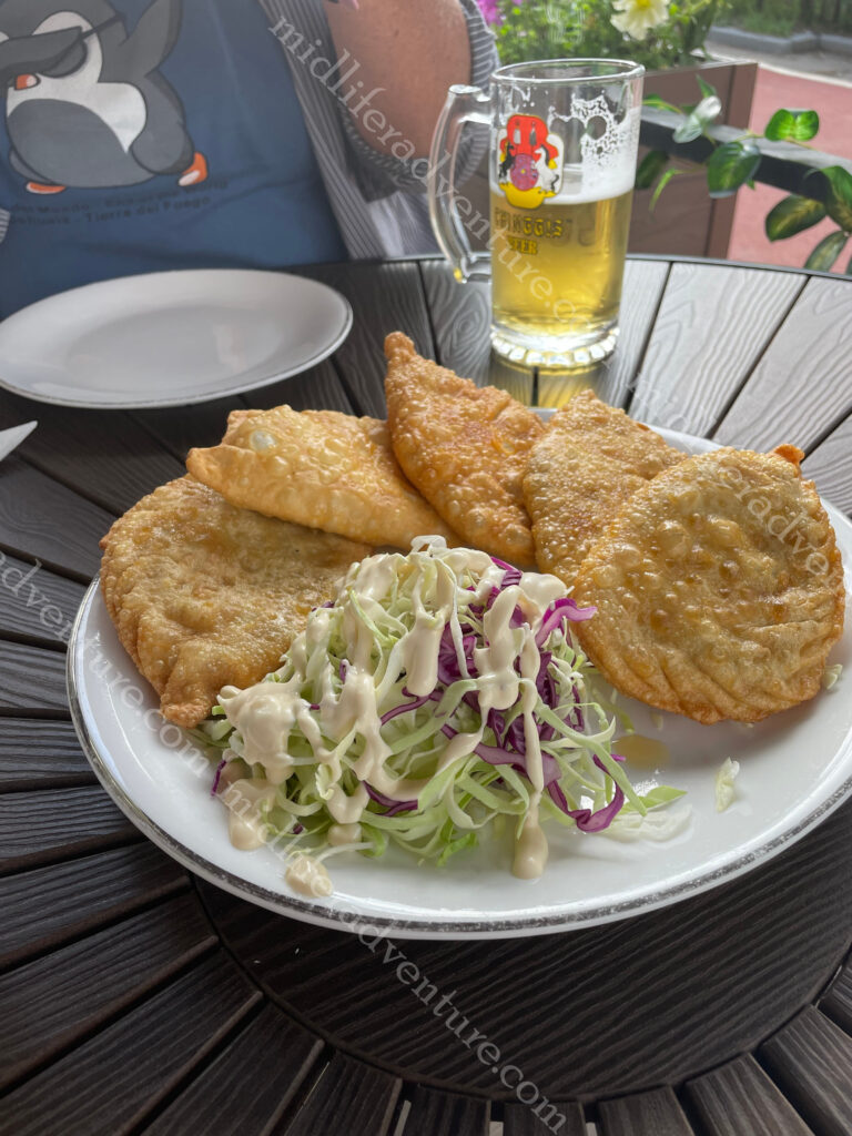
Khuushuur or Huushuur – A local version of a deep fried meat pie that more resembles a pasty or an empanada. The filling is just meat and onion.
It was the first thing that we ate on night one as a beer snack (they looked small and bite sized) but they came out the size of your hand and we ended up not needing dinner.
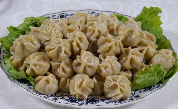
Buuz is the Mongolian version of the steamed dumpling commonly found throughout the region. It is basically a local version of the Chinese baozi or the Nepalese Momo.
Bansh is like the buuz but smaller and boiled in a soupy kind of broth rather than steamed. The filling usually comes from either a cow, goat, sheep, horse, or camel.
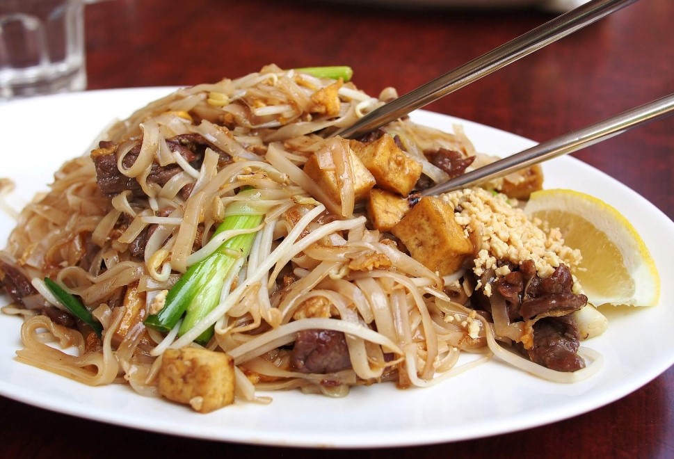
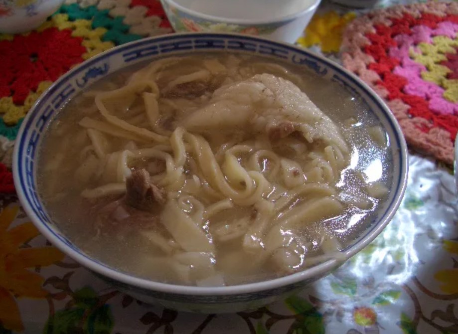
Tsuivan is a local stir fry made with home made fresh noodles with vegetables and a meat of some kind. Not the most thrilling meal about, but hearty and filling.
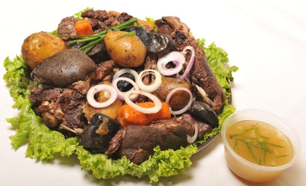
Chanasan makh is next and it is basically just boiled meat. Not really too much to say about this one, it is what it claims to be.
Khorkhog is a goat stew that uses the entire goat and is cooked on open fire with hot rocks. The quirk here is the belief that holding the hot stones after cooking helps to relieve tiredness and improve blood circulation.
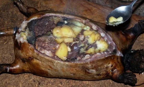
Boodog involves using the actual skin and fur of the animal as the cooking vessel. The animal is butchered with skin remaining intact and is sealed up having been filled with the meat, vegetables, and hot rocks to cook from the inside out.
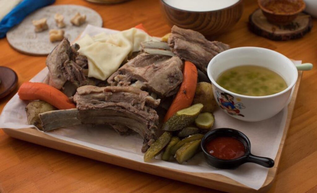
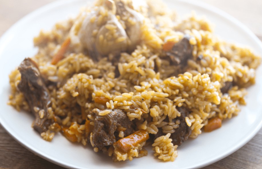
Guriltai Shul is one of the most popular noodle soups in Mongolia. It is considered to be the classic dinner staple – basically just boiled mutton with handmade wheat-flour noodles.
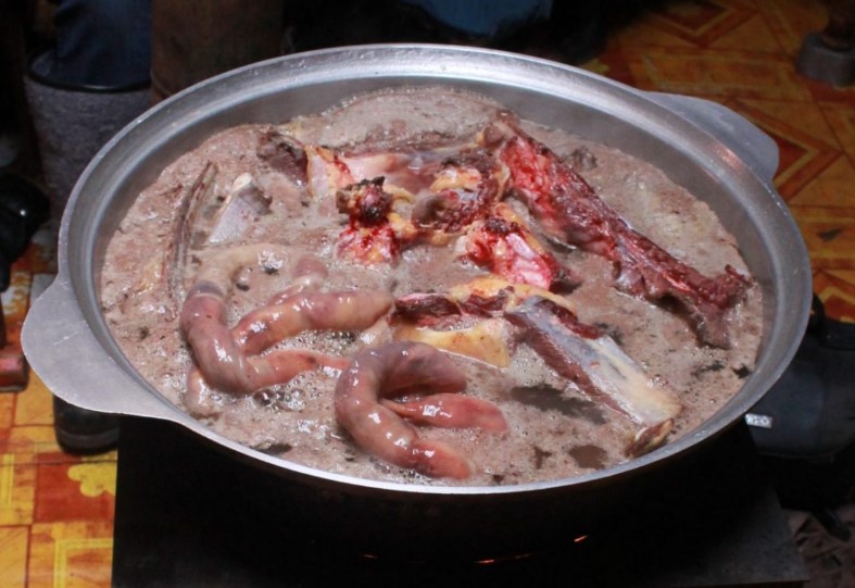
Vitals soup is popular for being very nutritious. It is part of Mongolia’s culture that no part of an animal is wasted and so Vitals Soup is offal. Made with the lungs, hearts, intestines, liver, stomach and kidneys of an animal.
Needless to say that neither Jill nor I rushed to order the Vitals soup. Budaatai huurga is a nice simple (inoffensive) local fried rice version with mutton.
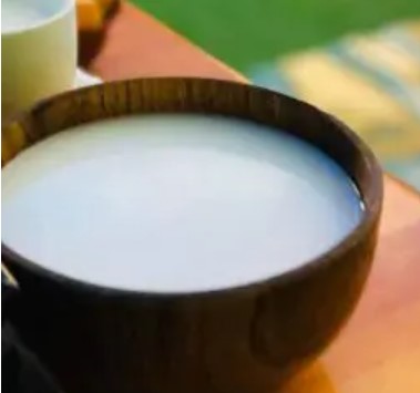
Last and definitely least is Airag, or Kumis this is considered to be the country’s national beverage. It is fermented mare’s milk. We had it in inner Mongolia a decade ago and it was terrible. The memory was strong enough for us to both avoid it at all costs.
Mongolian Beer
This was a tough one. Having once had such a mighty empire, the beer was highly variable. Some of the best beers that we have had were in Kyrgyzstan who had adopted the best of Czech brewing practices to deliver some really tasty beers, and you could find some really tasty ones here. But at the same time the empire stretched east, which brought into play the lighter Chinese style brews. These were much more gassy and less flavoursome.
Possibly the hardest part of the beers was working out what you were actually drinking. Niislel (Нийслэл), Sengur (Сэнгүр), Borgio (Боргио), Golden Gobi (Алтан Говь), Jalam Khar (Жалам Xар) and finally the only one I could get my tongue around, the Chinggis Pilsner.
Japan has long been on my list, and has been recommended to me by virtually everyone who has ever been here.
The issue that has kept us away for so long was the perception that it was prohibitively expensive. The Japanese pricing just did not fit with our cheap and cheerful travelling style.
Japan is made up of over 6,800 islands but with four main ones being Hokkaido, Honshu (the “mainland”), Shikoku, and Kyushu. Tokyo is the capital and largest city, followed by Yokohama, Osaka, Nagoya, Sapporo, Fukuoka, Kobe, and Kyoto. About 75% of its area is mountainous.
The most fascinating thing about Japan is the obscure blend of ancient traditions and cutting-edge modernity. Rich and often ancient cultural heritage combines with groundbreaking technology all set in a land of amazing landscapes and wildlife.
The decision to come happened on two fronts, the first was convenience, our journey to Mongolia was easiest with a transit through Japan and secondly, the exchange rate with the AUD was the highest it had been in over two decades.
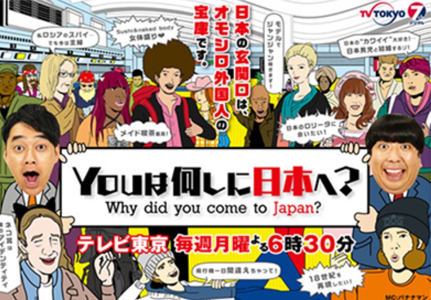
Our arrival saw us entering Tokyo, Japan’s bustling capital in mid evening, only to be jumped upon by a TV film crew, who wanted to interview us for a local travel TV show. It was a fluff show about where have you travelled to, why did you come to Japan and what did you want to see. The answer to the first question blew them away and we spent the next 30 minutes answering questions about our travels so far. Jill’s hat (with all of the pins on it) drew amazement and the thought that two people would just pack up and disappear seemed totally impossible to the Japanese mindset.
We have no idea if we were selected to be on TV (as we had left by the time it would have aired) but it was to be on Monday evening at 6:30 pm on Channel 7 TV Tokyo.
After this, we very quickly learned that our language skills were heavily lacking. Some serious bumbling about in the train station and we were on our way headed for the hotel. Some weather prompted a train change and some more confusion, but for the most part, getting about was fairly manageable. We finally landed in the hotel after 11pm having left metro Manila 14 hours earlier.
The next morning it was up for a quick breakfast and out exploring. The first thing that strikes you about Japan is how clean everything is. The footpaths are at least 4 meters wide and can be up to 10 meters wide in the busy areas. There is not a rubbish bin in sight but there is zero trash, anywhere. It was even a struggle to find a leaf laying on the ground. And there is no obvious person sweeping up or cleaning anything, people are just tidy and don’t make mess..
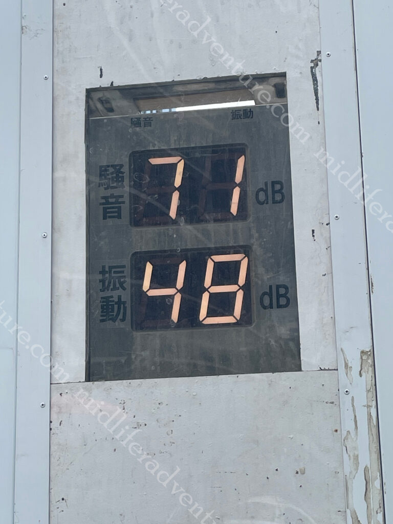
Not only is it clean, it is quiet. Having spent the last 2 months in the Philippines and Indonesia, this place is absolutely silent. No honking, beeping, screaming, yelling.
It was lovely.
It was so quiet that there were even decibel meters on the outside of constructions sites to make sure that things stayed at a reasonable level.
Our walk around was on a 30+ degree day with high humidity. Our first stop was to the NihombashiBridge that has been linking the city for centuries. The first wooden bridge was completed in 1603 and the current one dates from 1911. In reality the bridge is dwarfed by everything around it, but it is nice.
Next we aimed for the Imperial Palace, but to get there we went via the Tokyo Central railway station. Within no time of getting to the train station we immediately felt that we were in the world’s most populous city with over 37 million people inhabitants. And the majority of them were here.
To say that this place is a maze is an understatement. There is quite literally an entire underground city here. There are kilometers of underground tunnels and passageways that link the high speed rail (shinkansen) to the subway and you can even walk to the nearest five stations completely underground (the furthest a distance of over 2 km), but is faster by train. There are more than 4,000 trains arriving and departing daily.
Having been lost underground for what seemed like an eternity, we popped out relatively close to the Tokyo Imperial Palace and Gardens Area. Here we learned an important lesson. In the most populace city in the world, if you want to do something, you must book, days in advance, and you must queue up for your allotted time slot.
We did not do this, so were content enough to view the palace and gardens from the outside and did not venture in. But suffice to say that the surrounds were also pretty amazing.
Being a cool 33+ degrees with high humidity we chose to walk. From the palace we walked through parks and gardens, stopping at the various shrines and temples that we came across on the way.
From here our exploration took us into the Ginza District which is considered to be one of the most expensive, elegant, and luxurious city districts in the world. It is a popular upscale shopping area (something that we typically try to avoid). Our aim was to go to an interactive digital art museum that offers galleries of immersive and surreal installations (but guess what, you had to book, days in advance). So we wandered around lost for a while, found a place with an (happy hour) amazing lunch which set us back $26 for four beers and a feed. We did however make the booking for 4 days later.
The next morning it was up and on our way to see the lively hub of Shibuya. This is arguably the youth heart and soul of the city. For us it is the home of the scramble crossing, the busiest pedestrian crossings in the world, with sometimes over a thousand people crossing the multi-cornered intersection at a time. The view from the Shibuya Sky observation deck offers an epic view.
When we were there, extensive roadworks had stifled the flow of both traffic and pedestrians. But the tourist trade and normal business activity still meant that the place was manic, god knows what it would be like in full flight.
Japanese Street Fashion – To say that Shibuya is eclectic would be an understatement. The streets of Shibuya are the birthplace to many of Japan’s fashion and entertainment trends.
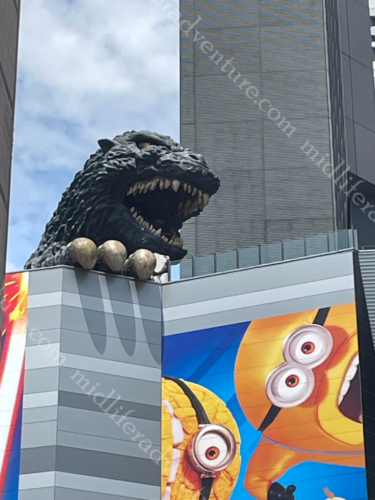
Just down the road we headed into Shinjuku to see the Godzilla, towering over the Toho Cinema. It is probably the most famous statue in all of Tokyo but on closer inspection, it is just a head and claw.
The area is busy and lively and I was offered sex at 11am by some random dude who wanted to take me to the nearby brothel. I just had to follow him down the alley.
Next it was on a train to the old part of town (Yanaka) where the old town ambience and atmosphere (shitamachi) reminds people of Tokyo from past decades. It was a funky little neighbourhood without the lights and bling of those we had visited before. The main attraction was the Yanaka Cemetery where many of the tombs are elaborately decorated and nicely landscaped. Paths are well-kept and wide, making it a good place for a tranquil stroll (even in extreme temperatures).
From here we hopped on the local bus and made our way to the Asakusa neighbourhood. Our main reason for going there was to see the Samurai and Ninja Museum, but guess what, you had to book. Thankfully the wait was not too long so we went exploring first.
The first thing that we stumbled across was the Asahi Beer Tower and Asahi Super Dry Hall with its characteristic Flamme d’Or. This was completed in 1989 and is the headquarters of Asahi Breweries.
With some time to kill we kicked back in the backstreets, checking out some funky little shops and restaurants, and even a Kabuki theatre.
Asakusa’s main attraction is Sensoji, a very popular Buddhist temple, built in the 7th century. Having snuck in around the back (it is free to enter we just came the back way) through the side streets we came out from what is usually the main entrance Nakamise. This is a shopping street that has been providing temple visitors with traditional snacks and souvenirs for centuries.
Having seen the masses of people, the temple and bought out our souvenir trinkets we headed back to the Samurai and Ninja Museum which turned out to be a great way to kill an hour or so. Some interesting history, and lots of swords and armour. You can even throw ninja stars against walls and dress up for photos if you want (we passed on the dressing up). The coolest bit was that there was some seriously good artwork on the walls.
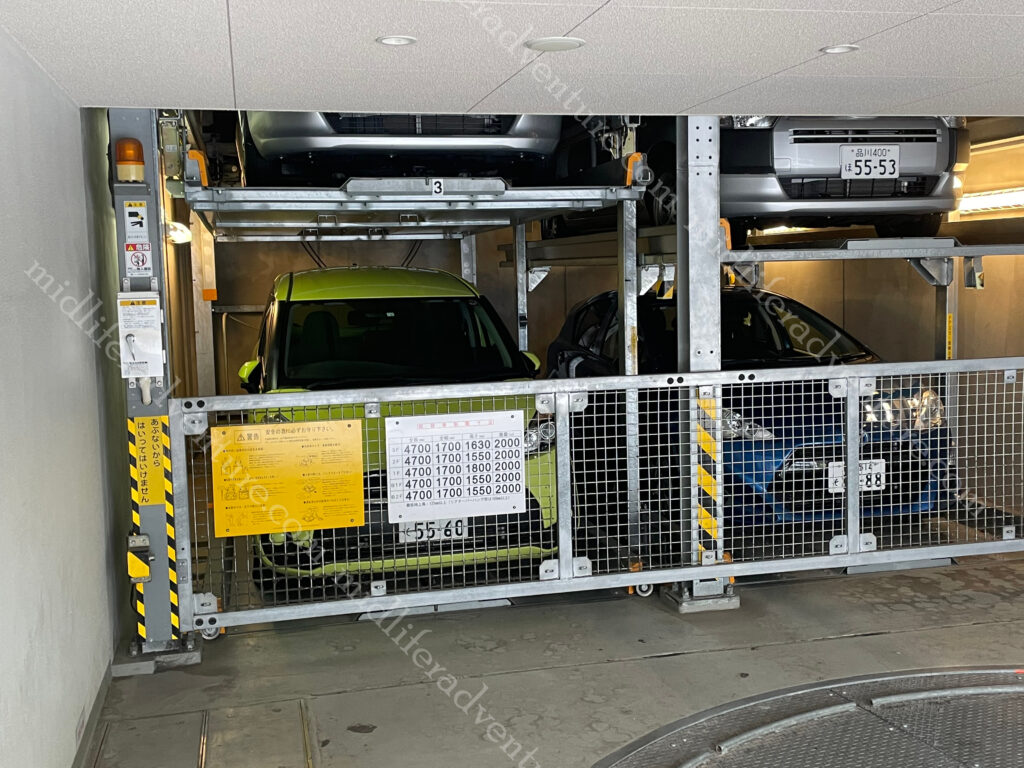
Space being a premium here in Japan, even the parking structures were a bit different to what we were used to. I had heard of the stacking system, but had not seen it in action before.
Jill being a raw fish fanatic had been humouring me in the preceding days giving me actual cooked meals, but the time had come for her to get her sashimi fill. We found a restaurant around the corner that allowed here to load up on raw fish and all was right (for her) in the world.
Japan is highly regulated (socially) and it is easy to inadvertently do the wrong thing. But a little bit of preemptive reading and the sort of things that will cause offence are actually pretty sensible and easy to avoid, if you only bother to look. Things not to do in Japan:
be late
be loud
talk on the phone on the train
tip at restaurants
stand on the right side of the escalator
wear shoes on tatami (woven straw) mats
These are actually really really easy to avoid, and for the most part, make life a little more pleasant. Virtually everyone that we came across followed these rules easily. Except the Americans and the French. Whether these two groups are just above such petty conventions or are just too arrogant to care, I do not know. But the only voices that could be heard splitting the silences were always one or other of these two accents, consistently.
The next day was the closest thing to a fail as we have had in years. Don’t get me wrong, we had a lovely day, but apart a fleeting glance (of Mount Fuji) from a train window we did not achieve our goals. We had seen photos like the ones below and thought what a great way to spend a day, so we hopped on the fast train (it is 140km away) to see it.
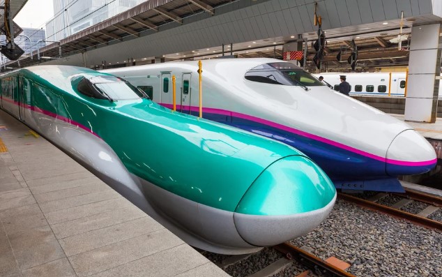
Japan’s Shinkansen, or bullet trains were our transport. They are world class with some reaching speeds exceeding 321 kilometers (200 miles) per hour. The newest versions have reached speeds of up to 603 km/h (374 mph) in testing.
While in transit, Jill did snap this photo (and a few like it) out of the train window.
So we did see the mountain, just not in the way that we had planned.
Getting off the train we hopped on a slower train that (we thought) would take us closer to the mountain and more specifically Lake Kawaguchi.
Lake Kawaguchi is located at the northern foot of sacred Mt. Fuji, Japan’s highest mountain. This is one of the Five Lakes of Fuji and you can enjoy magnificent Mt. Fuji views from the lakeside. But we got on the train to Odawara and then another to Hakone (still 60kms away from the mountain). To be fair there are about six locations in Hakone where you can enjoy good views of mount Fuji (but we did not go to any of them).
Instead, we got on the Hakone Tozan Cable Car thinking that it would give us the views that we sought. This is one of Japan’s few mountain railways where passengers can enjoy scenery and be wowed as the train climbs steep slopes. In order to climb the mountain, the train zigzags up the slopes using switchbacks where the conductor and driver switch positions. The cable car connects Gora and Sounzan and meets up with the ropeway to Owakudani (which was of course shut due to the winds). So we got near the top of the mountain with the views (on the opposite side) and could go no further.
So a long story short, we left our hotel at 7 am and got back late in the afternoon, in that time we had traveled on fast trains, slow trains, cable cars and saw some amazing sights of rural Japan. But what we actually came to see we got in fleeting glimpses as we went passed it on a super fast train.
As we waited to head home, I did manage to get a few videos of the superfast trains going past.
To say that these are fast and impressive is obvious. These ones even slowed down as they were passing the station.
We did have a great day, and we did see some amazing sights, we just did not really achieve what we had set out to do.
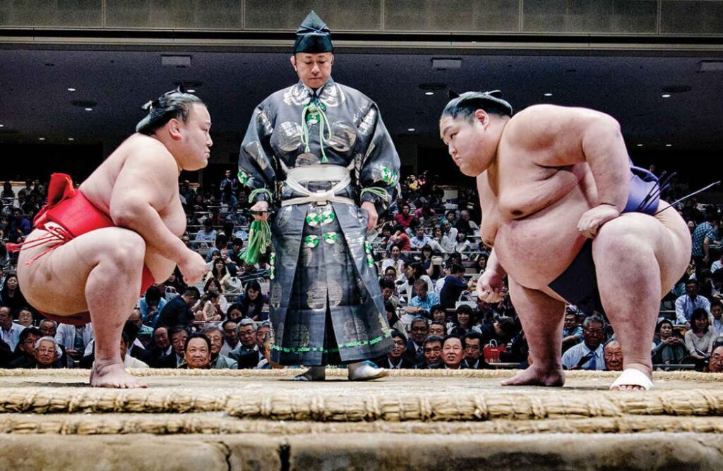
Sumo is a thing that we missed out on while we were here. It is a Japanese style of wrestling and Japan’s national sport with grand sumo tournaments (each lasting 15 days) held six times a year (the odd months).
While we were in Tokyo, there was a tournament on 350 km away in Nagoya. When there is no tournament you are able to head to one of the Sumo Stables to watch the early morning practice sessions. But these are suspended when a tournament is on (so we missed out).
As big as Sumo wrestlers are (many over 200 kg and the heaviest ever maxing out at 288kgs), doctors reckon that they don’t suffer from heart attacks, strokes, or display other symptoms of obesity. Sumo wrestlers consume up to 7,000 calories a day. The secret is in the name, as wrestlers the regular intense exercise prevents the build-up of visceral fat, which causes metabolic and heart disease.
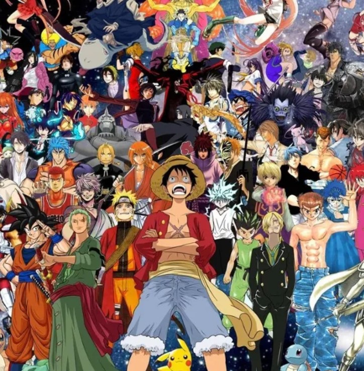
Manga is the Japanese term that refers to both comics and cartooning. The origin is believed to date back to the 12th and 13th century.
After WWII the manga were distributed widely to the population as a distraction from the harsh realities that Japanese people had to face after the war.
They are characterised a distinctive art and narrative style. Genres include action, romance, fantasy, science fiction, and more.
Anime is a Japanese style of film and television animation.
The style is distinctively Japanese and immediately recognisable.
Kabuki is a form of Japanese theatre that mixes dramatic performance with traditional dance.
It is known for its outlandish performances, glamorous costumes, and the elaborate makeup.
Not wanting to miss out, our reservation for the interactive digital art museum finally came up on our last evening in Japan.
The creators describe itself as an international art collective existing at the intersection of art, science, technology, and the natural world.
The group consists of a variety of artists, programmers, engineers, animators, mathematicians and architects; the collective aims to explore the relationship between the self and the world, through new forms of perception.
In reality it was a really high tech maze in darkened rooms with images and lights projected on the walls.
This is actually an over simplification, the lights sensed the presence of a person and bent around you, the exhibitions flew from room to room and around corners.
And colours changed, kids drawings were brought to life and flew across the walls, it was all pretty surreal.
To be honest we have seen almost nothing of Japan. Everything that we did see, we enjoyed but it is a seriously weird place. It is like nowhere we have ever been. Both relaxing and infuriating at the same time. I got totally sick of being lost in underground bunkers, railway stations and shopping malls. We were constantly staring at the GPS trying to work out where we were in an underground land of no reference points.
The exchange rate doubling made it actually really affordable for us, so if things remain favourable, I could envisage us coming back at some point. The food was magnificent.
A major point in us hanging about in and around Indonesia is that we had been invited to our mate Brad’s (featured regularly) milestone birthday party in the Philippines. So we returned to the Philippines from Indonesia and met up with a group of people who were similarly inspired to attend.
Before the festivities began in earnest we managed to get a few days catching up with people in downtown Makati.
We got to see some great friends (some long time readers of our travels), met some new ones and got to know some previously casual acquaintances better.
Our accommodation was in downtown Makati and was perfectly reasonable, with a rooftop pool and ideally located amongst the bars and restaurants.
The only issue with the hotel was that it had the slowest lifts we had ever experienced, and that there was no separate service lift for the staff. This meant that every time you entered the lift, there was 2-3 staff members moving about from floor to floor. This included large cleaning trolleys, maintenance staff with tools and ladders, room service trolleys. Virtually every trip in the lift (which fits about 6 people) had at least two staff members in there.
This got even worse when you worked out that floors 3 to 5 were administration floors and the office staff would routinely get on at 3 and off at 4, for the next to get on ad 4 and off at 5. And the same in reverse as you went down. It is a symptom of having old buildings, with no service elevators, but it is something that is very rarely encountered and was more than a little annoying.
A relatively large group of Brad’s friends assembled for the do, with most flying in from Australia. The main party was to be on a boat on the weekend, but the crew started assembling from about Wednesday night. This meant that some pre-party get togethers and catch ups were to take place, well before the actual event.
When the day of the party finally arrived, several of us had already embarked on 3-4 late and liquid nights in a row. This may be fine when we were in our 20’s, but none of us fit that bill any longer. The party boy had arranged (or rather Nora had) for a bus to pick everyone up and take us to Subic Bay and return us a couple of days later. Needless to say, there were esky’s on the bus, and a couple of comfort stops (and a rare appearance of Mike’s legs in shorts)..
Subic Bay
The actual party was to be held on a boat cruising the magnificent Subic Bay. This is a bay on the west coast of the island of Luzon about 100 kilometres (or 3 hours) northwest of Manila Bay. The Bay is a protected deep-water harbour and has been the focus of maritime conflict for hundreds of years. Subic Bay has been occupied by Spanish, Japanese and American military forces and played a pivotal role in both the Spanish-American War and World War 2.
Brad had us all checked in at a (once) amazingly lavish hotel right on the beach. While not a shadow of its former glory (there were photos) the place was lovely and a great time was had by all there (still not party day).
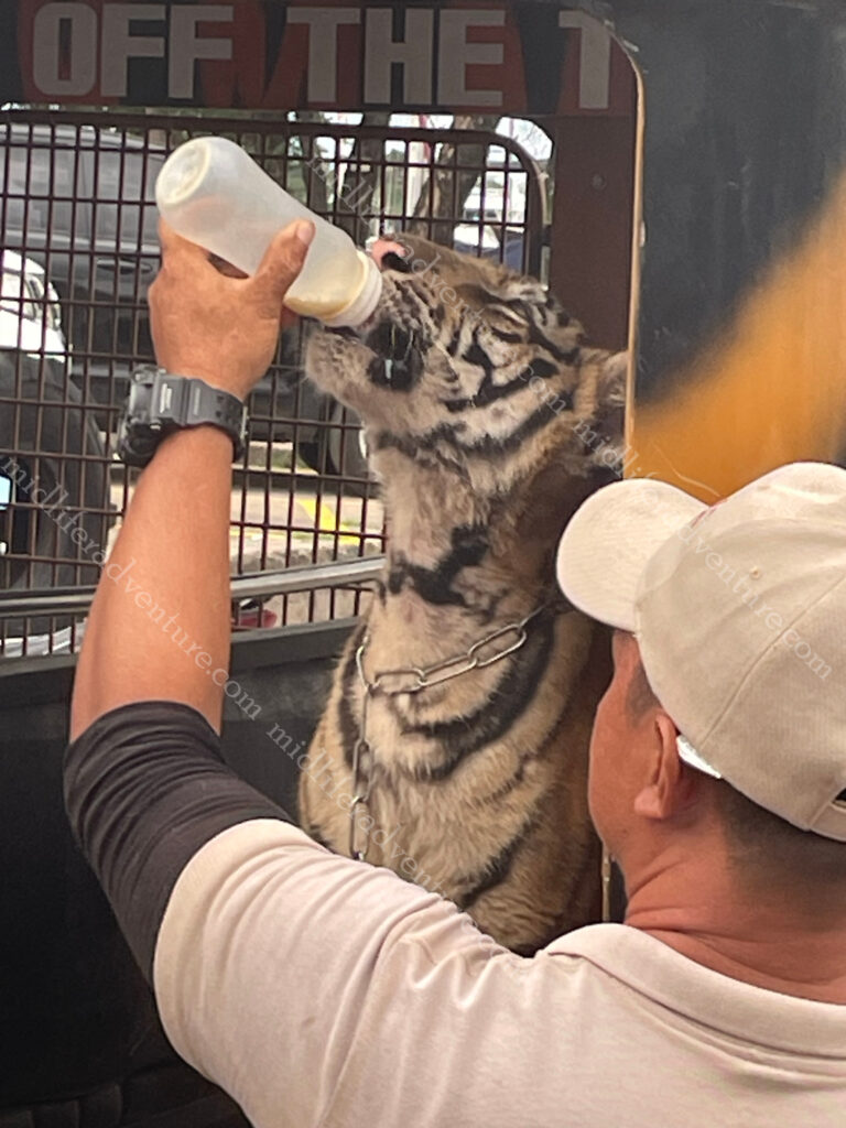
Finally the day came and we all loaded on the but from the hotel to the marina where we were surprised, nay shocked, to find a tiger on a leash (baby) wandering about the carpark.
It was from a local wildlife park and was a promo to try and get people to attend.
It was an unexpected surprise.
At the marina, a minor miscommunication and panic, followed by a very calm and pleasant boat journey and meal.
The only real issue that was felt was the Philippine contingent’s excitement over singing happy birthday. Having done the song, there was ‘a one more time’ and another, and another. After the fifth rendition the Aussies tapped out and walked away. I believe that there were several more after that.
Party over, back in Manila, some departed on early flights while others hung around for a few more days. Those that stayed, planned an impromptu visit to the neighbourhood of Intramuros and more specifically Fort Santiago. Intramuros was the seat of government during Spanish rule (1571 until 1898). Spain surrendered the Philippines and several other territories to the United States and the American flag was raised at Fort Santiago on August 13, 1898.
In December 1941, the Japanese Army invaded the Philippines, taking the city. In January 1945, the battle for Manila began when American and Filipino troops (including guerrillas) confronted the occupying Japanese force of 30,000. The result was heavy damage on the city.
At one point on the second last day we were seated at a restaurant having lunch and decided to share photographs with those in attendance. This saw Jill and I as the youngest at the table and a bunch of people trying to work out what buttons to push on the technology in order to get the desired result. Needless to say that this was not a quick or simple exercise.
During the conversation the concept of how to make the ‘airdrop’ function work arose and much bumbling ensued. After a while I commented (to an unnamed member of the party) that you needed to turn yourself on first. Within a fraction of a second his darling bride responded with no worries there, he knows how to do that.
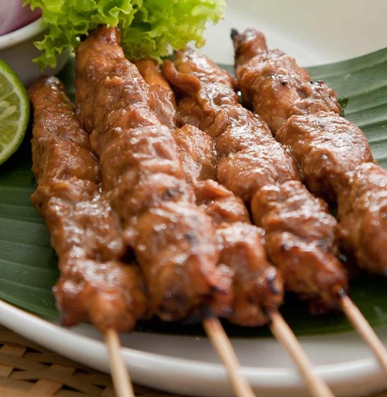
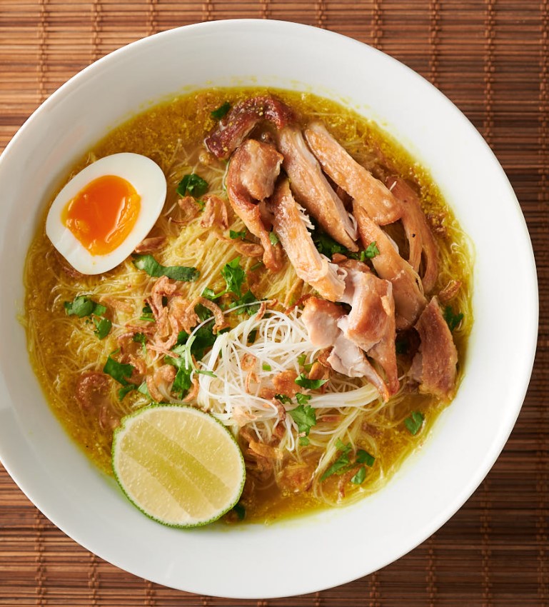
Indonesian food is both incredibly diverse and also incredibly boring at the same time. Initial impressions are amazing, but after a few days it all seems the same (Satay, Nasi Goreng and Mie Goreng). But if you persevere, it becomes really interesting again.
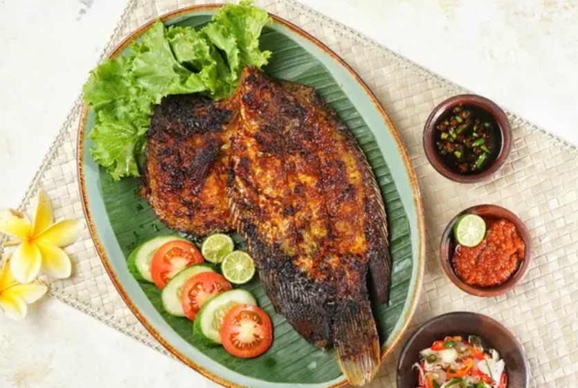
Satay is the first thing that you will likely find and fall in love with. Simple meat skewers, cooked over coals and served with a spicy peanut sauce poured all over the top.
It is a national dish conceived by street vendors and is practically everywhere but be warned, the quality varies dramatically.
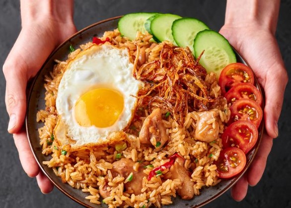
Nasi Goreng is a basic fried rice with a fried egg on top. A breakfast staple and perfectly acceptable.
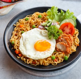
Mie Goreng is identical to Nasi Goreng, but made with noodles instead.
Equally as tasty and equally ubiquitous.
Siomay is Indonesia’s version of dim sum but nowhere near as good. This version contains steamed fish dumplings, with potato, cabbage, and egg, all served with peanut sauce.
Usually sold on the streets from a bicycle vendor with a large steamer at the back of his bike.
Gado Gado is a vegetable salad served with the magic peanut sauce.
Some come deconstructed and others come as a sticky mess. Most have boiled eggs and tempeh (fermented soy bean cake).
Ikan Bakar is everywhere. It is basically just grilled fish with a spicy marinade and an even spicier side sauce.
This is where many people run out, and while they are all fine, the Mie or Nasi Goreng breakfasts every day do tend to wear a bit thin. Indonesian food does typically tend to be quite spicy, so those seeking to lessen the chilli impact tend to settle for these safer choices. But if you box on and delve a little deeper into the cuisine, it gets interesting again.
Beef Rendang is ubiquitous throughout the region but originated in Sumatra, Indonesia (although my previous forays were always in Malaysia).
It is essentially beef, slow cooked in coconut milk with a bunch of chilli and spices.
And it is delicious.
Nasi Rawon is a beef stew with a nutty flavour and a deep, black color from the use of keluak nut.
It is rich in flavor and is generally eaten with a bowl of rice (big surprise there).
Sop Buntut is basically just an oxtail soup.
The Indonesian version is as popular as ever and is a healthy and hearty soup.
The oxtail is usually fried or barbecued before being combined with the soup base.
While on soups, the Soto Ayam is the local version of a basic Chicken soup.
Super simple and tasty and filled out with vermicelli noodles.
Bakso is the local meatball noodle soup.
Usually sold out of a pushcart on the street means that you can expect to get your fill for a couple of dollars.
Martabak – in Indonesia, there are two types of martabak, namely salted/egg martabak which is made from a mixture of eggs and meat , and sweet martabak, which is usually filled with chocolate and goats cheese (Jill’s favourite).
Nasi campur literally just means mixed rice. But in Indonesia it refers to rice with a variety of Chinese meats like char siu, pork belly, roast chicken, or egg, all served with sweet tangy sauce.
Typical side dishes
Sambal, this is on every plate, all the time, Tempe is next and has already been mentioned, the next most obvious is the water spinach that accompanies almost everything, Singkong (chips made of Cassava rather than potato). Acar is a mixed vegetable pickle (cabbage, carrots or beans, shallots that are heavily spiced with chilis), Krupuk is the prawn cracker type thing that you are used to, Lemang is a coconut sticky rice (typically cooked in bamboo over fire).
And of course my favourite, Belado (a spicy blend of ground red chilies, shallots or onions, garlic, tomato, tamarind, sugar, and salt). Belado means hot and spicy. Usually served on eggs as Telur Belado but also smeared on almost everything (the crispy tempe was particularly good). This became my regular daily breakfast.
A long story short, if you cannot find a great meal in Indonesia, you are not trying. Everything is easily available from your local Warung (roadside stall) and you will pay very little for it. But if you really need to eat what you know, then (as long as you stay on the beaten path) there are western options everywhere you look in the tourist hubs. These quickly disappear once you get off the beaten path though.
Leaving Sorong (thankfully), we hopped an early morning flight to Jakarta and than on again to Belitung. While it was just a transit we were struck with the ingenuity shown at Jakarta airport with their fire extinguishers. Rather that being necessary ugly lumps on the wall they have been painted in a way so as to simultaneously disguise them while at the same time highlighting their location.
Belitung
Beltung is an island north of Jakarta and off the east coast of Sumatra , Indonesia. It is famous for white pepper, seafood products and tin mining.
It is slowly becoming known as a natural tourism destination, particularly for its white sand beaches and granite boulders.
The first thing that struck us about Belitung was that the place was really clean. The telltale (Indonesian) rubbish was not everywhere, there were not burning piles of green waste polluting the air and the whole feel of the place was good. The roads are in great shape and compared to almost everywhere else, the traffic is surprisingly light.
We either stayed too short or too long on the island, depending upon your point of view. It is a place that you can blitz in a day or two, or it is a place that you can kick back for a month.
When choosing location Jill picked the close to town (and food) option rather than the further away beach option. Our hotel was nice, right on the water with an infinity pool facing west. During low tide there was almost a kilometer of sand before you hit the water and at high tide you were surrounded. Facing west, the sunsets were pretty good.
There are not too many things to do in Belitung, with the majority being on the northern part of the island. It is surrounded by lots of tiny islands and granite rock formations. With such surrounds it has made it the perfect place to get in a boat and go island hopping, which was written up as by far the best thing to do.
With that as the benchmark, after a couple of days we signed up to do the day tour. The majority of these involve a pickup from and drop off to the airport or sometimes a hotel. This suggested that the island was a literal day trippers location from Jakarta (one hour flight). The itinerary of the tour was to include: Tanjung Kelayang Beach, Sand Island, Batu Berlayar Island, Lengkuas Island, Kelayang Island & Kelayang Cave, Tanjung Tinggi Beach.
Tanjung Kelayang Beach was the boat meeting and launching point.
Tanjung Kelayang also has the Tanjung Binga Fisherman’s Village nearby for those that want a taste of local traditional life. The beach itself was nice with the renowned granite boulders.
A short distance away you get to Garuda Island With the mythical bird shaped rock formation poking high above the others. Here it is a quick stop (for us at least) for some photos. The local tourists spent about three times as long making sure that they got their pictures.
Next was Batu Berlayar Island and this is when both Jill and I looked at each other and decided that this is where we should have stayed. Not the island, but on the mainland opposite. The stunning white sand beaches, turquoise water, rocky granite islands, underwater coral reefs, and even the Dutch lighthouse were all visible and it was amazing. Oh it was also the location of the big 5 star chain hotels, but there were a few cheapies interspersed in there for us.
Just off the beach (and not mentioned in the spiel) is the Lenkaus Island and the Old Indie Lighthouse. This is an old Dutch lighthouse dating back to the 1800’s.
After the lighthouse we had our obligatory snorkelling stop. The snorkeling was ok quality, however after Raja Ampat really did not compare. There was certainly lost of (hard) coral and small fish but the turtles, tropical fish and larger predators where nowhere to be seen. I did however manage to perfectly capture on film (above and below the water) exactly why the reefs of the world are in such a terrible state. It was a group of local tourists pausing for a selfie while standing directly on a live head of coral.
The next stop was to our lunch location on Kepayang Island. A nice (clean) sandy beach a restaurant in the sand and an included local lunch. A beautiful mix of prawn, crab, calamari, and grilled fish all served with steamed rice, grilled water spinach and a healthy amount of sambal and chilli on the side.
Last stop was possibly the most photogenic of the beaches in Belitung, Tanjung Tinggi Beach. It has perfect blue-green water and giant boulders.
Most of the clouds that had been stalking us all day had mostly burnt off and this was very clearly a beach for the locals. Tons of local restaurants, more inflatable animal floaties than I had seen in years and a nice, flat calm ocean.
But most importantly for us, they had beer. We had been dry for the preceding five days. On a local, Muslim island, beer can sometimes be a bit tough to find. Our hotel did sell them but at prices that exceeded what you would pay back home. So we stopped and had one and took a couple home. Oh the beach is a good sunset spot too.
The tourist walk to town was fairly uninspiring, with very little around to see or do. The roundabouts were a little entertaining, but for the most part we were just in a local community on an out of the way island.
On our tourist wander we went past Pendam Beach which is the beach closest to the main town Tanjung Pandan. As a west facing beach it is popular as a spot to watch the sunset.
Penyabong Beach is a more secluded beach in the southwest about 1.5 hours from town. We did not make it but reports say that it has white sand and no crowds, but recent commentary indicate that trash has built up over the years.
As I mentioned at the beginning, we either stayed too short or too long on the island. A short trip could be done and dusted in 2-3 days but we stayed six. This was mostly to avoid being in Yogyakarta (and the temples) on the busy weekend. But the island is nice, accommodation and food is very affordable and if we had stayed further north (which we would do next time) the access to beer is a little easier.
But paying local prices and staying close to the beach up north, could warrant a bit more time and some further exploration.
Yogyakarta
Yogyakarta is one of the foremost cultural centers of Indonesia it was the seat of power during the 8th and 9th century and was the driving force behind the creation of the temples of Boribudur and Prambanan. It is a city that maintains the traditional concepts of Javanese culture.
The town itself was nice. It was clean with plenty of food and drink options available. The sights around town were interesting enough, without being amazing. But the real attractions were just outside of town. While I say just outside 42 km (Borobudur) and 17 km (Prambanan) respectively. But these still take at least an hour and a half to two hours to drive to due to the terrible state of the traffic. Not the roads, they are fine, the traffic.
PrambananTemple
Prambanan Temple was our first port of call, it is the largest Hindu temple in Indonesia. It is not certain when this temple was built but it is thought that it was built around the middle of the 9th century by the king of the Sanjaya dynasty.
The complex is actually a series of four temples (Prambanan, Lumbung , Bubrah and Sewu) with the main one giving its name to the complex.
The original plan of Prambanan Temple was rectangular, consisting of an outer courtyard and three courtyards. The outer courtyard is oval in shape with an area of 390 sqm and was surrounded by a stone fence which is now in ruins.
The second courtyard, is rectangular covering 222 m2. This courtyard consists of four terraces, with a total of 224 identical (6m square and 14m tall) temples. Almost all the temples in the central courtyard are currently in ruins.
The inner courtyard is considered the most sacred place it has a rectangular floor plan covering an area of 110 sqm. Three of the 8 main temples are called Trimurti (“three forms”) temples, dedicated to the 3 highest Hindu gods: God Brahma the Creator, Vishnu the Preserver, and Shiva the Destroyer (the biggest and central one).
In front of the Trimurti temple there are 3 smaller temples that have been dedicated to the transportation of the gods (the ox Nandi is Shiva’s vehicle, the swan is Brahma’s vehicle, and the Garuda is Vishnu’s vehicle).
At 3pm every day you are kicked out of the main temple (zone 1) but can hang out (in zone 2) for the next few hours. In the same complex as the Prambanan Temple you will also find the Lumbung , Bubrah and Sewu Temples (allegedly the best place for the sunset photos). Added to this is the Archaeological museum.
There has been a lot of effort that has gone into the restoration of these temples and the newer works are quite obvious (possibly even amusing). There has been an element of improvement as opposed to restoration that has been taking place.
In reality it was only the western tourists that ventured beyond the main temple (on foot anyway). The local tourists looked at Prambanan and the really adventurous ones caught an electric golf cart to Sewu and ignored the rest. It was only the few of us that hiked the whole complex and viewed each of the temples.
Borobudur
Borobudur is the largest Buddhist temple or shrine in the world, it was established in the ninth century and covers a square of 123 meters, with 9 platforms – the first six are square and the last 3 are circular.
In the 14th century, when Java’s population converted to Islam, the temple was abandoned and people forgot about it. In 1814, the British ruler of Java (Sir Thomas Stamford Raffles), re-discovered the temple with the help of a few locals. According to Buddhist teachings…this monument is a model of the universe and was built as a holy place to glorify Buddha as well as functioning as a place of pilgrimage to guide mankind from the realm of worldly desires to enlightenment and wisdom.
Borobudur built in the style of Mandala which symbolizes the universe in Buddhist teaching. This structure is square shaped with four entry points and a circular center point. Working from the outside in apparently the three zones of consciousness are represented, with the central sphere representing unconsciousness or Nirvana.
The temple walls are decorated with 2,672 relief panels and (originally) 504 Buddha statues, the largest and most complete collection of Buddhist reliefs in the world. The main stupa crowns the building and is surrounded by three circular rows of 72 perforated stupas (with a Buddha statue in lotus position in each).
As a tourist 400,000 ($40) rupees will get you in and the price for locals is 50,000 ($5). It is an extra $7.50 to climb to the top but be warned, these are bought out by the tour operators days in advance. They are available on the day but at full price (even if you have already bought the normal entry ticket on line).
Borobudur is on all a bunch of the bucket list items that generally surface. The spiels say that it ranks with Angkor Watt and Bagan as one of the great archaeological sites of Southeast Asia. Having been to all three, suffice to say that Jill and I were underwhelmed. It was ok but it was not worth the flights, accommodation, hellish car ride, high entrance costs and return journey. This will go in the OK been there done that category rather than the wow box.
Travelling the world in a pre and post COVID state